Dear Diary,
Perhaps you remember that we left off, two pages ago, with an account of my hikes June 26 and October 10, resting at the Eddie McAbee Entrance on the latter date.
The reason I needed to rest is that I was about to hike to the city limits to visit the only park in North Seattle more isolated from other parks than Carkeek Park:
Llandover Woods
Each time I've gone there, I've taken the direct route, up 3rd Ave NW. I've gradually learnt that this was only a terrifying experience the first time because I'm really bad at finding sidewalks. 3rd has sidewalks on the west side of the street from NW 100th to about 115th Streets, and on the east side for all but one block from NW 120th to 145th. So there's only occasionally reason to risk the traffic. Wimps could, of course, take Greenwood Ave N, which has good sidewalks the whole way.
Anyway, upon reaching 3rd Ave NW and NW 145th St, one is confronted with a sign:
Here's that sign's map a bit closer:
Now, on June 26 I read that map as clearly showing that the entrance to the trails was west on NW 145th. So I considered taking a video of the uninterrupted trees along there, but settled for a photo, and went on speculating that maybe the project had run out of money.
On October 10, on the other hand, I noticed that star at the park's northwest corner, which seemed to be reachable via a pretty simple series of winding streets. So off I went.
Anyone who ever does the same should please compare the map above with, you know, a real map first, so as to know that after NW 137th St and a long trek along NW Northwood Road, one must turn at Alpine Way NW; not knowing this, I wound up in someone's driveway. Somewhere along the way, I learnt that my destination is in a literally gated community, Llandover by the Sound:
Anyway, though, after shorter stints on NW Culbertson Drive and Sherwood Road NW, one eventually does reach that starred entrance, and yes, there really is a woods there:
Eventually I stumbled onto the path back to 3rd and 145th, and thus discovered that the actual trail entrance is not on 145th, but behind a parking lot that is, in turn, behind this pillar:
which is south of the original sign and its map.
Just inside that entrance is a more useful map:
which helped me as I trudged back to where I'd left my cart, waited out a rain squall, and then climbed back up every one of those winding roads again. Which is quite enough of my stupidity for today.
Along good sidewalks of 145th and then Linden Ave N, each time evening was nearing as I visited
Bitter Lake Reservoir Open Space
This is an odd park. Like Froula Playground and Maple Leaf Reservoir Park, it's built on the grounds of a Seattle Public Utilities reservoir. Unlike those, its pervasive theme is water: a couple of fitness machines that require pumping motions, a see-saw decorated with dolphins and sharks, a P-Patch, and the gorgeous water play area, turned off this year, that greets people at a formal entrance:
But none of this means there's a water fountain, let alone a restroom.
The park was pretty crowded in June, but not in October.
The next Seattle Department of Parks and Recreation park is down Linden a ways, near N 130th St, but first, it turns out rather more of the reservoir site is parkified than is an official park:
The outer fence, in front, is just because the land across it is well below the sidewalk. All the way to the inner fence way back there is open to the public, acres and acres it seems.
Bitter Lake Playfield
This is the park I've found most changed this year, unless you count places like Christie and Fritz Hedges Waterway Parks.
The lake is this playfield's most memorable feature; it's on the northwest border. Along most of the east lies the Bitter Lake Community Center, which unlike the other Community Centers in "N" and "NW" does not contain restrooms with outside doors. Instead the restrooms are a little southeast of the park's middle.
The first time I visited, there were people camping all along the lake shore (though carefully not blocking scenic outlooks), and a little to the east of the lake, along the park's north edge. The restrooms stayed open at least until 9:05 P.M., and people told me they were open 24 hours. The water fountains weren't running. The park was bustling.
The second time I went, as at the reservoir, was much quieter. One reason is that the plumbing had flipped: the restrooms were locked but the water fountains were on. Everyone had moved their tents away from the lake shore to another location, though tents remained along the park's north edge. A fence leaned against the shore bushes blocked one of the outlooks.
I talked with two women campers. The one who did most of the talking said, in response to my imagining that the parks department was trying to shift people to Woodland Park, that the only deal she'd been offered was trash pickup, and that seemed to be breaking down. She said, and Rachel Schulkin, parks department communications manager, confirmed, that the restrooms had been closed for a construction project. She also said she hadn't seen any construction for a while; Ms. Schulkin, who didn't believe that the restrooms had been 24 hours, seemed upset that the restrooms hadn't reopened, though by mid-October the writing was already on the wall, the seasonal restrooms uncertain at best. (The construction was lighting, unfortunately not winterisation.)
So all my new photos of this park are darker than the old ones. This is partly for personal reasons; those were the only restrooms I'd expected to see between Carkeek that morning and Northacres the next morning. But partly, I didn't much like the casually negligent way this park's summer activity had been stilled. Anyway:
Two of Bitter Lake's scenic outlooks:
The geese, this time not on the lake:
Hmm. Those buildings looked shabbier to me than this photo makes them.
Speaking of shabby, the fenced-in scenic outlook:
And the restrooms, which I couldn't find closed last time, but now:
Haller Lake Street End
This is at the end of N 125th St; across the lake NE 125th St begins. As this implies, we aren't especially close to the Bitter Lake parks here; Northacres is actually closer. I don't know whether this park has a formal connection to the street end program; it's practically a model of the concept, but not on any list I've seen.
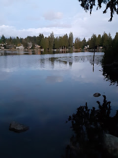
Each time, I reached this park in twilight. Somehow, each time I decided that it made sense to shoot a photo facing east across a small lake at sunset. In contrast to the Bitter Lake parks, this one was much busier at the (much earlier) October twilight than in June; I had to negotiate with fishermen to take this:
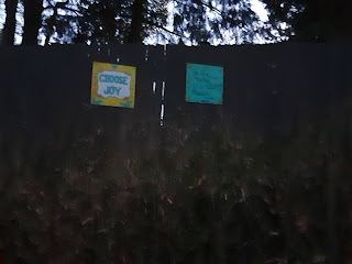
And now for something literally, but not figuratively, much darker. For whatever reason, people living next to the park are waging a duel of positivity. Despite the limited light, I couldn't resist trying to document a sample of each side:
Madison Pool and Ingraham Playfield
Madison Pool is both the northernmost and the most approachable of the pools in North Seattle that I've visited in this year of closure; in fact each night, of June 26 and October 10, I slept there. It is, as a result, where my June notes go away, so I just photographed what I wanted to, starting with where I slept:
See that bench, next to the building name? There's another opposite that one, hidden in this photo by the planter, and I slept each time sitting up on that bench.
But my real reason for taking this photo is the building name. This pool isn't named for a slave-owner, but for Helene C. Madison, who moved here as a child and won various gold medals and set various world records in swimming. I found a site called Olympedia informative in relation to her ties to Seattle.
Although the pool is closed, it turns out that a surprising amount of land is attached to it, even though everything is on the grounds of Ingraham High School, and most of that land is parkified:
Speaking of Ingraham, a line about the Ingraham High School Playfield showed up in the 2020 Seattle real property report as a parks entry. I assume what's meant is at least this:
Well, that's my report on the top of the city outside "NE". Next come updates and supplements to the first two "Top of the City" pages, and then a bunch more pages. I'm sorry, dear Diary, that it's so hard for me these days to get to Wi-Fi to write in you; I know it's silly to have such a lot left in mid-November.


No comments:
Post a Comment