Showing posts with label Wallingford Steps. Show all posts

Sunday, August 2, 2026

Under Construction, part III: A.B. Ernst Park Before

Dear Diary,

Please inform any reader of this part who really loves A.B. Ernst Park, and who is reading before sunset on April 2nd, that they should stop reading right now and go make some last memories in the park they love.  Because on April 3rd, trees are going to start being taken out.

So at this point, your readers, dear Diary, are either people who don't love that park, or are reading after sunset, right?

This reminds me that I don't know, and haven't known for a long time, who reads you, dear Diary.  Strictly speaking, I don't even know that anyone reads you; for all I know, the numbers I see are all artificial intelligences being trained.  But even if that's not so, I mustn't assume any baseline level of familiarity with the work I've done with your excellent help.

So.  Dear Diary, you are a blog about public amenities, and especially about public restrooms whose doors open to the outside, and public water fountains that are outside.  Most of these things are in parks, and because variety is the spice of life, sometimes, as now, I just do some park appreciation without talking about plumbing at all.  The area we've focused on is the northern part, a sort of peninsula, of the City of Seattle, in a northern border state of the United States.

At one of the peninsula's southern tips, towards the middle east-west, is a neighbourhood called Fremont that likes to call itself the centre of the universe.  Parts of Fremont and its more staid eastern neighbour Wallingford are pretty hilly, and possibly as a result, three of their parks have as their raisons d'etre that they allow people to traverse those hills.

The Wallingford Steps are the flashy sibling, made of concrete but with spectacular artistic adornment, plus, yes, some plants.  They're the most successful as stairs, too, linking N 34th St with N Northlake Way, and, across that perilous street, with Gas Works Park and the Burke-Gilman Trail.

Troll's Knoll Park is the plain, friendly sibling; challenged to praise it, Seattle Parks calls it "sustainable".  It connects N 36th St with N 38th St adjacent to Aurora Ave N.  Just east of its bottom is the Fremont Troll; at its top is the Troll's Knoll P-Patch.

But A. B. Ernst Park almost ignores its stairs, which unimpressively go from N 35th St to the next alley south.  Instead it focuses on being a quite beautiful park, one worth spending time in. 

But tomorrow, motivated mainly by access and activation, Seattle's Department of Parks and Recreation will start changing A. B. Ernst Park.  I would be pretty shocked if the result of the changes isn't loved, by some, within a year or three - Seattle Parks generally knows what it's doing.  But that doesn't mean I can't celebrate the old version.

I learnt on my second recent visit that what I see as this park's signature element is not what everyone sees.  I went across the street and discovered that what drivers see is mostly a couple of giant street trees.  But if, like me, you walk west from the Fremont branch library (soon to close itself for construction), there's no doubt at all that A. B. Ernst Park is mainly about these spectacular pillar-like trees.


These are arborvitae (Thuja occidentalis).  Another species that's prominent in the park is bald cypress (Taxodium distichum).  And how, you may ask, dear Diary, do I know these things, having never displayed any botanical knowledge before?  Alas, this is how:

There are many signs like that attached to specific trees; there are also quite a few on the ground.  Other trees bear different symbols:

Well, as I mentioned not too long ago, dear Diary, I'm having technical difficulties.  Let me describe the planned work, and then close with two more photos.

Most people, I think, understand this park as a winding path with a weird structure in the middle, sort of a crude theatre.  The occasion for the work is that Parks acquired a bit of land east of the park.  So they're moving the path eastward, and widening it, because even though the park's current page says it "provides wheelchair access", paths can never be too wide when considering Access.

And then they're giving the space thus created at the west end of the park to Activation.  A picnic table will be where the park entrance now is, and south of the table will be an "embankment slide" with "hillside loops".  That area will rejoin the main path at the head of the stairs.

If I'm reading the plans right, it's a goal to keep the theatre-like area, and the artwork that surrounds it (Water Mover by Jenny Heishman) more or less intact.  But they're planning to remove half of the arborvitae, so I expect it to be a long time before the park feels right to me.

Well, dear Diary, writing this part in you on my phone has been horribly time-consuming, so I'm going to have to find a better way soon.  Until then, happy days and nights.  The first photo below shows arborvitae, theatre and Water Mover, while the second shows the stairs at the bottom of the park.


Saturday, May 1, 2021

While Strolling in the Parks One Day, part I

Dear Diary,

Ooh, it's just like old times!  I went on a long hike today, and now begin to tell you all about it just as if I were always so prompt.

I decided that since I've yet to start anything in "N" - that is, between "NE" and "NW" - it was time to do so.  Especially since I had errands today on N 45th St and N 36th St, to run along the way.

While I've been working on behind the scenes stuff, dear Diary, I've been re-reading you, and it's been frustrating watching myself keep making rules against taking photos.  So I set off on this hike with the attitude that I must visit each park in my target area, and must take at least one photo at each.  I didn't go so far as to consult the 2021 Seattle real property report, which I just found out has already been released to the public, and which provides the most authoritative list of parks in town, though I'll probably do that before my next long hike.  But anyway I meant to go back to all the parks I already knew about.

This page, and part II tonight, are for the parks from the north side of N 50th St to the Ship Canal, in Wallingford, here defined as lying between Stone Way N and 1st Ave NE.  I do think Wallingford reaches further east than that, but it was much easier to assemble the list of parks without having to check each NE address.  As things are, I'll have to write a part III tomorrow, because I forgot one park and one street water fountain that I did know about.  But here are the ones I didn't forget.

First, however, something of an executive summary:  As of today, several weeks after the weather warmed up, no park water fountain between N 50th St and the Ship Canal was running.  The fountain at B. F. Day Playground, the only one running last October, is not running now.  I didn't test every fountain in Woodland Park, which has several trillion of them, but did try half a dozen, including the only two that ran last October, and none of them ran either.

Between this and other reporting, it looks like our mayor really is waging war against water addiction, as I satirically suggested last year, and it might be summer again before bottles of water stop functioning as currency among the homeless.  Or maybe it'll be that way until all lockdowns end, or at least the mayor's office changes hands.

In the meantime, as we're about to see, the map I made the January hikes to check is now actually out of date as to park offerings for hygiene for this area:


- yes, that's right, the map which lied all winter about restrooms being open that weren't is now omitting restrooms that really are open - but, anyway, the map knows of no other places, charities, libraries, whatever, where people can get water in the region I walked today.

EDIT 5/11:  I figured out today how to insert maps from the Open Street Map project, and may have figured out how to edit them, though not, as yet, how to edit them with precision.  The two maps that follow are an overview of the region, and a map of the area covered in this page specifically, but don't take the inserted letters and numbers in the second map as exact guidance.


Meridian Playground

I've told you and shown you quite a lot about this park already, dear Diary, including my first two videos, because I like it a lot.  I summarised all that January 3 in "Hike 1A:  Inconvenients", and hadn't been back until today.  (Though I did reflect on its hugeness for a "playground" January 6 in "What's in a Name?")  Anyway, knowing this was one park I hadn't stinted, I didn't photograph but the bare minimum this time.  The restrooms were open:


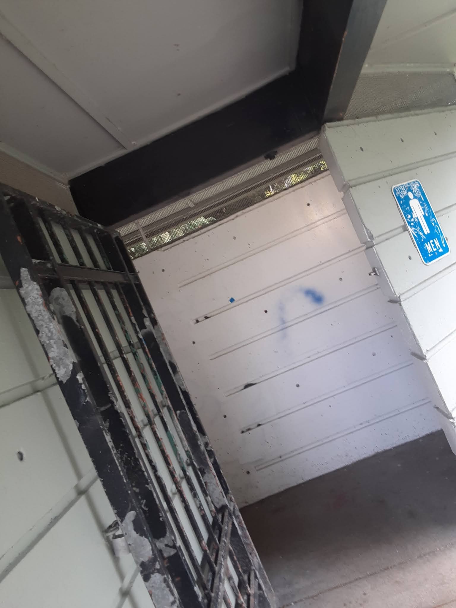
The men's room photo is tilted so as to get the sign, but avoid a man who was lying on his sleeping bag under it.

The water fountain remains in an advanced state of decay:


Yes, that's grass visible through what should be the drain.

The shelter remains inhabited, and having recently pointed out that the campers in Woodland Park seem less secure than they were, I should mention something else that I don't think I've shared with you yet, dear Diary:

The Seattle Department of Parks and Recreation is not accepting reservations for several park shelters, mostly in North Seattle, to wit Gas Works, Ravenna and Woodland Parks, and Meridian Playground.  All but Ravenna Park's shelter were inhabited or in closely related use by homeless people when I surveyed the shelters in my October hikes, and to the best of my recollection also during the January hikes, though those focused less on the shelters.

En route

A block south of the park border on Bagley Ave N stands a "sanican".  It isn't near any visible construction site, so I was curious whether it was a defensive measure put up by neighbours, in which case it would be unlocked, or near a non-visible construction site, in which case it would be locked.  Neither case quite applied:


Not far from there, I found an early work of someone who is obviously a park planner in the making:


Oh, dear, it looks like the sign isn't readable.  It read something like "Please enjoy the dinosaur garden.  Please don't touch."  I was impressed.  Most non-green bits of colour in the photo are toy dinosaurs.

Corliss Place

As previously reported June 8 in "A Shower at Green Lake", this is a traffic triangle.  As previously reported January 6 in "What's in a Name?", it would take a more dedicated park-lover than me to find something nice to say about this park, but anyway here, at long last, is a photo:


Wallingford Playfield

The references for this park are the same, but I've been much less enthusiastic about it, and only started paying my arrears in January.  So I took the same photos as at Meridian Playground, but also the only landscape angle I could find that wasn't full of people:


Unfortunately, the others really are the same photos.  In January, I noticed that the water fountain had been fixed, and allowed myself to hope that there would be park water in Wallingford this year.  Not yet:


At least the restrooms are open:


The Wallingford Steps

I went through Seattle's 2020 real property report more or less line by line last January, and listed everything in North Seattle I thought might prove more or less parklike.  I found seven places particularly interesting:  they're areas owned by the Seattle Department of Transportation, which classifies them as parks.  The Seattle Department of Parks and Recreation only classifies two of these as parks in its own list, in other words maintains web pages on those two but not the rest.  The Wallingford Steps and Peace Park are those two, and the Wallingford Steps is the only one of the seven in today's target area.

Three parks in Wallingford and Fremont are organised around big height differentials within them.  This is the most determinedly non-ADA, and the fanciest.  I've previously, June 9 in "At the Centre of the Universe, Does Gas Work?", shown you, dear Diary, a picture of these steps' central landing/mosaic, but I haven't tried to show that to you in context, illustrate why the parks department might accept this as a park.  Here's a try:


And that's where this page had better stop, dear Diary, because I have a bunch of photos of the next few parks, and Blogspot gets cranky if I use too many in one page.  Until a little later.


Tuesday, June 9, 2020

At the Centre of the Universe, Does Gas Work?

Dear Diary,

Two pages back, I wrote about the parks with "N" addresses, as opposed to "NE" or "NW", between about 45th and 80th Streets.  I neglected to mention two things.

First, I spent the night of June 5 in bus shelters near Meridian Playground.  So I saw that park both at night and in the morning, and saw Woodland Park mainly in the morning and afternoon of June 6.

Second, park restroom stalls without doors are pretty much the default in that area, though there are certainly exceptions.

OK, then, it's time to move south.  Since I'd just finished (ha) with Woodland Park, I stayed that far west, so started with Fremont, which has no large parks, and only one water fountain.  Fremont has much more folklore than most Seattle neighbourhoods, most of which I suspect I'll never get, not being a baby boomer.  In particular, it's called the centre of the universe.  Well, then, the centre is seriously under-parked.

Small Fremont Parks

The only kind there is.

Fremont Peak Park

I reached this by going south on Greenwood until I could switch to Palatine.  This is a silly route even if, like me, you're coming from Woodland Park.  Much better to just take 45th St to its end, and then turn south a little.  Anyway, this park is primarily about its view, which I found boring, but it has a sort of mini-Stonehenge meant to tell the seasons:
which looks cool whether or not it works.  The park knows this, too, using circle imagery in a couple of other places.

Fremont Canal Park

Verizon pretended to be unable to retrieve the parks department website most of the afternoon of the 6th, so I didn't learn until I was much further on the trip that I'd ignored this park's western half.  It spans two long blocks between the Burke-Gilman Trail, which there runs alongside the Ship Canal, and the street (Canal Street).  The eastern block is full of dinosaurs:
OK, yeah, topiary ones, but still.  The western block is in "NW" anyway.  By this point it was clear enough that I'll have to go to Ballard after all, so I'll just look at that block then.

A. B. Ernst Park

This is next to the Fremont branch library.  It's basically a transformed stairway:  riotous vegetation all around it, and the upper half turned into a gentle ramp, along which are some weird tiers.  It's apparently slated for expansion (and presumably construction), so if this interests you more than it does me, you might want to hurry there.

Troll's Knoll Park

No, this doesn't include the famous sculpture by, um, Steve Badanes, Will Martin, Donna Walter and Ross Whitehead, which is about the only bit of Fremont folklore that works for me.  It's to the left, as you face the troll, where all those concrete bollards are that you always see people leaning against.  The park apparently wants to move those people way uphill to a small grassy strip next to a P-Patch; fortunately, instead the kids and the gardeners stay at a distance.  The park is more successful in its claimed ambition to assist people in getting uphill; it features a fully paved, gently sloped trail with lots of switchbacks that took me from 36th St almost to 38th.

B. F. Day Playground

This park is, at 2 1/3 acres, not only the biggest in Fremont, but bigger than the other four put together.  This gets it not only a water fountain, but one that gave a tablespoon of water before going dry when I tried it.  It also, at the opposite end of the park, has a "sanican", not something I saw many of in this trip.  It's easiest entered from Linden Ave, just south of 41st St.

Four or More Wallingford Parks

Wallingford Playfield

This is bigger than all the Fremont parks added together.  That is, it's 4 1/2 acres.  By this point I wasn't up for much exploring; the park is easy to find along Wallingford Ave at 42nd St, the open restrooms and non-functional water fountain easy to find within.

A Detour

This was as close as I'd gotten to a supermarket all day, so I went and bought my daily salad, and also a bottle of water.  Which latter made me feel very stupid when I found this in front of the store:


The Wallingford Steps

Exactly what it sounds like:  stairs by which Wallingford Ave continues to the canal.  Or anyway to the next park.  What makes it a park is the usual luxurious plantings, plus some gussied-up landings, of which this one, by Benson Shaw and Clark Weigman, has pride of place:

Gas Works Park

I think every time I've visited this park I've been in a hurry, tired (as this time), or both, so I've never really explored it.  Maybe I'll try to do it justice before I finish writing you, dear Diary, but it isn't actually that close to the U-District - along Meridian same as the playground by that name, but way south.  Anyway, this is the closest to the U-District of the parks whose restrooms have been opened 24 hours, not that I've tested that.  I did want to use those rooms, but a look at the way both men's toilet seats appeared to be decorated with Number Two dissuaded me.  The water fountain attached to the restroom building isn't running.  But I don't know whether there are other restrooms or water fountains elsewhere in the park.

Waterways?

Either at the eastern end of Gas Works Park, or adjacent to it, are Waterways 18 and 19.  The parks department website doesn't list them.  The City of Seattle real estate report (PDF) I'm using for areas lists 19 but not 18.  I didn't explore either at all thoroughly:  I couldn't bring my cart, and my getting anywhere near one enraged the nearby crows.  They don't look like the kinds of parks, or parts of parks, that have restrooms or water fountains.

Sunnyside Ave N Boat Ramp

This is officially closed, but still has a "sanican".  It's hard to reach from Gas Works Park, along the sidewalks-optional Northlake Way; I suggest taking 36th St instead.  Geese were in possession when I arrived, but took offense at me and left, giving me a chance for another mediocre duck photo:

From there I caught the Burke-Gilman Trail straight to University Village and Safeway.  I'd forgotten, at the Wallingford QFC, that I no longer have the handy cutlery my backpack held.  Safeway was in a panic because a rally was getting close, and closed early, so I never did get to a toilet that night, but it worked out OK (and I did get a fork to eat the salad).

For the past two weeks I've been aware that it isn't the right time to state my own grievances.  And the inspiring sight of thousands of people cooperating in marching down (NE) 45th St does nothing to make my course of action seem nobler.  Dear Diary, I had hopes at the start that powerful people might read you, and might do things as a result.  Maybe that's still possible, but probably not before I finish writing you.

As my energy allows, here's what I think is left.  There are eight parks left in "N" between 80th and 145th Streets.  That real estate report alerted me to six parks I hadn't known about in the northern parts of "NE", though four are Natural Areas, unlikely to offer restrooms or water fountains.  And since I still haven't found an area with water fountains consistently on, such that I could say the problem is local, I might as well endure the forty-odd parks of "NW" so I can sort of talk about North Seattle as a whole.

But this all assumes we aren't going back to the days of randomly closed park restrooms.  And assumes that the rain will occasionally pause for a day or two.

Sorry, dear Diary.  I just don't know how much longer until I finish you.