Showing posts with label mobility. Show all posts

Friday, September 4, 2026

Dunn Gardens: Initial Impressions

Dear Diary,

Dunn Gardens, a seven-acre private park in northwest Seattle, poses several ethical questions for you and me.  You see, now that I know about it, I know of two parks in North Seattle where restrooms are hidden behind a paywall.

There are important differences between the two in this respect.  Woodland Park Zoo isn't a member of Museums for All; Dunn Gardens is.  Woodland Park Zoo has physically structured its entrance to ensure payment; that's spectacularly untrue of Dunn Gardens.  Woodland Park Zoo, on the other hand, is very near count 'em ten free park restrooms, some of which are open 24 hours; Dunn Gardens is pretty much it for public restrooms within a square mile or three.

So ethics can only dictate so far.  Thanks to a very helpful employee, I was able to take slightly more photos than this page contains; I can't imagine that happening at Woodland Park Zoo.  And if that's unfair to the zoo, too bad.

Just the facts, please

Dunn Gardens is at 13533 Northshire Road NW.


It started as the summer home of Arthur Dunn, who died in 1945.  In 1952, before annexation by Seattle, the family sold some acres to avoid the land being condemned by the local school district.  As a result, some neighbouring houses, built on the sold land, claim to belong to the Shire.

There are indications many places, ranging from the paperwork related to the 1994 addition to the National Register of Historic Places (38-page PDF) to English Wikipedia, that there have been many restrictions on how open to the public the gardens really are.  However, today they're open year round, people needn't be guided by docents, and the remaining main restrictions are two.  They don't have much parking, and their hours are short, seven per day, closed Sundays.

In the unlikely event that a homeless wanderer was in whatever part of northwest Seattle is closer to Dunn Gardens than to Carkeek Park or Bitter Lake Playfield (nothing in Shoreline would be closer, but I have reason to hope both those parks' restrooms are 24 hours), the parking probably wouldn't matter, but the hours probably would.

Doing things right

What I think I like best about Dunn Gardens is several apparently recent innovations that have been done conspicuously well.

This includes the plumbing.


They didn't have to get a wheelchair-compatible restroom, or a year-round water fountain, but they did.  Their membership in Museums for All is recent.

I don't know how valid their apparent belief that their main market is the elderly is, but they're doing that right too.  An all terrain wheelchair, an automated external defibrillator, handrails in both restrooms.

A Place to Be

Dunn Gardens costs $10 per visit or $50+ per year.

They have maps more convenient than this one.  I recommend those maps' use.


I'm not, personally, that much into gardening.  Both my parents were, and the scene outside the office feels homelike to me.

But I'm not completely insensible to beautiful plants, as you perfectly well know, dear Diary.  In futures in which I don't return to homelessness, I'll probably want to come back occasionally, and not just to check on the plumbing.

Good night, dear Diary.


Building a Baseline, part IV: Around Seattle's northwest corner

Dear Diary,

This part concerns three places, one of which I've never seen, and a different one of which is quite far from the other two.  So it's a dubious gathering.

But that's what these hikes' version of "inconvenients" are like.  In part II of this page, I wrote "Most of North Seattle is, on the maps I drew, full of interesting places to go."  The first day I tried to visit 20 destinations, September 1st, only four were left for Northgate.  (I then ruled one out of that part.)  So I looked for isolated destinations that wouldn't take bites out of the main web, and this part and the next, about Bitter Lake Reservoir, are examples.  (Northgate and Bitter Lake itself are bites out of the main web, but ones I felt relatively confident about.)

Here's the usual OpenStreetMap map:


So let's go!

Unidentified exclusive park (A on map)

There's a vacant lot, about fifteen acres in size, just north of the City of Seattle park, seven acres, Llandover Woods.  This vacant lot goes up to the city's border with Shoreline.


From the website of the owners, The Highlands, I'm fairly confident that this lot is, or is part of, a park.  That website doesn't name most of their extensive parks, and specifically not this one.

The Highlands is a gated community in Shoreline; this may be their only Seattle property.  One gate, in the form of a guard station, is visible from near Llandover Woods's entrance:


I'm afraid, dear Diary, that this is the first of the five parks getting their first descriptions in your pages that I mentioned.  But the best of the five is also in this part.  If this park has an address, I don't know it; the King County Parcel Viewer doesn't assign addresses to vacant lots.

Llandover Woods (B)

This is a woodsy park at 14499 3rd Ave NW, with trails and distinctive benches as its main amenities.  I've only discussed it with you, dear Diary, once, I think, in November 2020's "Top of the City, part III".  Unaccountably, considering that I would soon start writing about topography, I left out any reference to its spectacular relief.  (Basically, Llandover Woods, and for that matter Llandover on the Sound, the home owners' association, are on the slopes of coastal cliffs rather like those I described, not very well, in "Land and Water in North Seattle, part II: The Lake City Coast".)


There are two main trails, one of which marches efficiently from entrance to exit.  The other wanders more, has less official trails branching off from it, and is simply more fun.  Unfortunately, to make that latter trail work, they had to include stairs.


I did have fun there, and will try not to let six more years pass before I visit again.

Dunn Gardens (C)

This is a garden property that boasts of being the only publicly accessible example in Washington of a garden designed by the Olmsted brothers, the same people who designed Ravenna Boulevard.  It contains two (not very) private residences, and I ended up leaving by the driveway of one.

Its management has a very clear idea of who its main audience is (unlike me!), and the gardens' home page brags about their "all terrain wheelchair".

This is a privately owned park, part owned by the E. B. Dunn Historic Garden Trust, and part by the owners of the private residences.  And I took way too many photos to fit into this part, and liked the place enough that I want to give it its own page anyway.  So that's the last page I hope to write in you tonight, dear Diary.

This much more teaser, though:

Baseline for the northwestern corner of Seattle:

Dunn Gardens - One water fountain, running, and with the sort of water delay that fountains at Northacres and Cal Anderson parks have.  They bought it expecting it to run all year, and it looks like they got their money's worth.  Two non-gendered single user stalls, one wider than the other and presented as accessible.  All at least notionally paywalled.

I hope to get back to you soon, dear Diary.

Saturday, August 29, 2026

Under Construction, part VI: Meridian Playground Before

Dear Diary,

I've visited Meridian Playground a bunch of times, recently, waiting for the fences to go up.  I know, now, why they haven't.  But first some context.

Meridian Playground is a fairly big park between N 47th St, Meridian Ave N, the Good Shepherd Center, and N 50th St.  Unlike the past several projects I've written about, I have no real complaints with regard to this one, although this is the main project that led me to say Access is a magic word to park project managers.

"This project aims to make site improvements to the play area ...  The project also improves accessibility to the play area and restrooms.

"Most components of the play area were constructed in the early 1980s, and revised in 2002, and some equipment was replaced ... in 2011."

In other words, this is some seriously tired playground equipment, older than most of the kids' parents, and on my first visit July 23rd, it looked tired, too.

It was easy to tell which was the equipment new in 2011, too:


What I couldn't figure out, though, was how the project was going to make the playground more accessible.  See all those curbs in the foreground of this photo?  There are curbs aplenty in this place, and walls, and even stairs:

The thing that was going to serve Access was a new path between the Good Shepherd Center parking lots and the area where the playground and restrooms are.  So on July 30th, I went planning to blaze a trail through the woods, and was completely gobsmacked to discover that this path already exists.  Not least because that meant I need never have damaged my carts on the crude pavement of the N Bagley St entrance.

But here's the thing:  Most Access projects described at the parks website emphasise that standards change, and what was good enough in the 1990s isn't good enough today.  Well, but actually, I'm pretty sure that path wasn't wide enough for the 1990s either.  If you go from the park side, it's plenty wide, right up until about where the park/center boundary must be, and then it narrows drastically.  Sure, my cart would fit, but I'm not sure I've ever seen a wheelchair that would.

So even if, as it sounds like at the project page and in its linked documents (4 page PDF), they leave all those walls, curbs and stairs where they are, there's still a solid win for real access in making the restrooms wheelchair accessible.  And they're also planning to remodel the restrooms to make them work better for people with that kind of disability too.

Still ...  The Good Shepherd Center has north and south parking lots.  There are, of course, no stairs at their entrances.  But the Center warns pedestrians not to use those entrances - and of course, there are stairs at the middle path.  Three shallow steps, as if to say "No" just to be difficult.

So yes, I still think Access is a magic word for Parks project managers.

Anyway, none of that is why the project is behind schedule.  It's behind schedule because of a stupendously successful marketing campaign.

"Picnic in the Park".  Who knew?

It turns out that the Wallingford Farmers Market, held in Meridian Playground, is the closest to my house, somewhat nearer than the U-District one.  The fact that I hadn't known this, dear Diary, tells you all you need to know about how much attention I pay to farmers markets, which I could never afford in my first years in Seattle.

So there I was, on August 19th, and so were hundreds of other people, including a purely amazing number of children.  I think the average age in that park was probably not much over 20.  And that tired old playground equipment was in glory.

So I predicted then, and the project page already said before July ended, a start date of November for this project, after the market shuts down for the winter.  I don't envy the construction workers.

Well, dear Diary, I'd hoped to tell you the much more boring story of construction in Woodland Park tonight as well, but I'd better go back to real property reports instead.  Until tomorrow, then, dear Diary. 


Tuesday, August 4, 2026

A detail note about labels

Dear Diary,

It's strange to think it now, but for most of your life, I've been housed.

For some time before then, I'd been pushing shopping carts, not stolen from a grocery store, but purpose-bought.  Your pages that I wrote while homeless include endless complaints about these carts.

Once I was housed, I got a laptop, and discovered Blogspot's categorisation system, which it calls "labels".  It doesn't show its labels to readers on phones, you see.  Soon I re-read all of you, dear Diary, and set up a system of labels.  And all those complaints about carts got the label "cart".

Unfortunately, so did less me-specific remarks about things that impede some people's ability to get around.  This is a particular problem for writing about the Seattle Department of Parks and Recreation's love of "access".

Now I've finally separated these two things.  Many pages are still labelled "cart", some are now labelled "mobility", and a few have both labels.

Happy days and nights, dear Diary! 

Sunday, August 2, 2026

Under Construction, part III: A.B. Ernst Park Before

Dear Diary,

Please inform any reader of this part who really loves A.B. Ernst Park, and who is reading before sunset on April 2nd, that they should stop reading right now and go make some last memories in the park they love.  Because on April 3rd, trees are going to start being taken out.

So at this point, your readers, dear Diary, are either people who don't love that park, or are reading after sunset, right?

This reminds me that I don't know, and haven't known for a long time, who reads you, dear Diary.  Strictly speaking, I don't even know that anyone reads you; for all I know, the numbers I see are all artificial intelligences being trained.  But even if that's not so, I mustn't assume any baseline level of familiarity with the work I've done with your excellent help.

So.  Dear Diary, you are a blog about public amenities, and especially about public restrooms whose doors open to the outside, and public water fountains that are outside.  Most of these things are in parks, and because variety is the spice of life, sometimes, as now, I just do some park appreciation without talking about plumbing at all.  The area we've focused on is the northern part, a sort of peninsula, of the City of Seattle, in a northern border state of the United States.

At one of the peninsula's southern tips, towards the middle east-west, is a neighbourhood called Fremont that likes to call itself the centre of the universe.  Parts of Fremont and its more staid eastern neighbour Wallingford are pretty hilly, and possibly as a result, three of their parks have as their raisons d'etre that they allow people to traverse those hills.

The Wallingford Steps are the flashy sibling, made of concrete but with spectacular artistic adornment, plus, yes, some plants.  They're the most successful as stairs, too, linking N 34th St with N Northlake Way, and, across that perilous street, with Gas Works Park and the Burke-Gilman Trail.

Troll's Knoll Park is the plain, friendly sibling; challenged to praise it, Seattle Parks calls it "sustainable".  It connects N 36th St with N 38th St adjacent to Aurora Ave N.  Just east of its bottom is the Fremont Troll; at its top is the Troll's Knoll P-Patch.

But A. B. Ernst Park almost ignores its stairs, which unimpressively go from N 35th St to the next alley south.  Instead it focuses on being a quite beautiful park, one worth spending time in. 

But tomorrow, motivated mainly by access and activation, Seattle's Department of Parks and Recreation will start changing A. B. Ernst Park.  I would be pretty shocked if the result of the changes isn't loved, by some, within a year or three - Seattle Parks generally knows what it's doing.  But that doesn't mean I can't celebrate the old version.

I learnt on my second recent visit that what I see as this park's signature element is not what everyone sees.  I went across the street and discovered that what drivers see is mostly a couple of giant street trees.  But if, like me, you walk west from the Fremont branch library (soon to close itself for construction), there's no doubt at all that A. B. Ernst Park is mainly about these spectacular pillar-like trees.


These are arborvitae (Thuja occidentalis).  Another species that's prominent in the park is bald cypress (Taxodium distichum).  And how, you may ask, dear Diary, do I know these things, having never displayed any botanical knowledge before?  Alas, this is how:

There are many signs like that attached to specific trees; there are also quite a few on the ground.  Other trees bear different symbols:

Well, as I mentioned not too long ago, dear Diary, I'm having technical difficulties.  Let me describe the planned work, and then close with two more photos.

Most people, I think, understand this park as a winding path with a weird structure in the middle, sort of a crude theatre.  The occasion for the work is that Parks acquired a bit of land east of the park.  So they're moving the path eastward, and widening it, because even though the park's current page says it "provides wheelchair access", paths can never be too wide when considering Access.

And then they're giving the space thus created at the west end of the park to Activation.  A picnic table will be where the park entrance now is, and south of the table will be an "embankment slide" with "hillside loops".  That area will rejoin the main path at the head of the stairs.

If I'm reading the plans right, it's a goal to keep the theatre-like area, and the artwork that surrounds it (Water Mover by Jenny Heishman) more or less intact.  But they're planning to remove half of the arborvitae, so I expect it to be a long time before the park feels right to me.

Well, dear Diary, writing this part in you on my phone has been horribly time-consuming, so I'm going to have to find a better way soon.  Until then, happy days and nights.  The first photo below shows arborvitae, theatre and Water Mover, while the second shows the stairs at the bottom of the park.


Saturday, August 1, 2026

Under Construction, part II: Themes

Dear Diary,

Well, I've been hiking, and have now visited six of the thirteen parks on my list for this page.  But technical problems are slowing me down, and anyway I can probably make the remaining parts shorter by putting these general remarks into one place.

Because, you see, dear Diary, Seattle's Department of Parks and Recreation has certain priorities when it comes to construction.  Let's start with a couple of magic words.

Activation

Parks cares a lot about how many people use its parks, and the particular feedback loop it embraces is known as "activation".

The idea behind activation is that there's always room for one more person in a park, and to the extent their budgets allow, park managers want to bring that one more person in, using techniques known to help in doing so.  I'm not sure believers in activation think there can ever be too much of it.

Now, I have a pretty jaundiced take on this whole activation ideology, because I'm not at all sure weird single middle-aged men are in activation's target audience, but I'm absolutely sure homeless people are not in activation's target audience.  In fact, activation is often presented as a way to discourage homeless people from being in parks, by outnumbering them with normal people.

Nevertheless, Seattle Parks embraces activation ideology, and it comes up time and again in their construction projects.  Specifically, they like to replace playground equipment, partly as trends in safety engineering change (and perhaps advance), but also because new equipment is a new chance to activate more kids.

Access

I'm not here, dear Diary, to object to the Americans with Disabilities Act of 1990, from which we all benefit in many ways, and from which I, personally, benefit in specific ways as well.

But already in my hiking, I've become convinced that the word "access", used in explaining park projects, has a weird meaning, at once narrower than it should be (a path can be made "more accessible" without removing stairs) and broader than it should be (any path can be made "more accessible" by widening it).  So, in Seattle Parks project management, "access" is a magic word, not a well thought out principle.

Synthetic turf

Not all park construction norms are magic words.  Seattle Parks has been fairly busy replacing natural playfield surfaces with synthetic ones.

Not being an athlete, I have no real opinion on synthetic turf as an experience.  It may well be less "ecological", but I've already visited one target for conversion, and no blade of grass will be harmed by the planned changes to Woodland Park's Field 4's infield:

As an accounting student, though, I have to admit that synthetic turf is a major bureaucratic win.  Instead of considerable expenses to mow, water, and so on - labor expenses, mostly, very high in Seattle - synthetic turf is an asset, and depreciates.  Replacing it is small change in capital budgets.  I don't know, though, whether it's also a win for taxpayers.

Single user stalls

Yes, dear Diary, Seattle Parks also has a norm concerning your core topic.  (Although both access and activation will come up in that regard as well.)

I think it's obvious that single user stalls aren't as efficient in using space as multi-stall restrooms.  Each single user stall has a sink, after all, and probably a dryer.  But I don't have proof, because I hardly ever know how big the women's rooms are, so I can't do before and after comparisons.

For example, the old Cal Anderson Park men's room had two stalls plus a urinal.  Did the women's room have two or three?  Impressively, Parks managed to squeeze four single user stalls into that building, which is either parity (ignoring for now the urinal) or minus one.  However, two of those four were damaged years ago, and aren't on the construction radar, so it's worse than that in practice.

Single user stalls are certainly safer, while people are in them, and that's not trivial - someone running away from someone else can take pretty good refuge in one.

Well, dear Diary, those are the things I wanted to sum up here.  The time I've spent hiking has been available because my instructor has given us some days to study before the midterm on Monday.  I hope to visit three more parks tomorrow, but that still leaves three in Lake City, plus Hubbard Homestead and a return trip to Woodland, to squeeze into several weeks of frenetic assignments thereafter.

As for when I'll tell you about these hikes, dear Diary, it's more of a hassle than it'd been the past few years, but less time-consuming than hiking, so I hope pretty soon.  Until then, happy days and nights. 

Sunday, November 13, 2022

Six Hikes in Brooklyn, part V: East

Dear Diary,

This part of this page concerns two hikes, on December 22nd, 2020, and on October 29th, 2022.  In a summary of the hikes two parts ago, I claimed that I'd also visited this area October 16th, and I indeed did walk past it, but the photo I thought was evidence of that visit turned out to be of an area covered one part ago.  (On the other hand, I went and took the photo I thought I'd taken, today.  So maybe not just two hikes after all.)

Since I visited and photographed all of these areas (except one) on each of the two hikes, this goes in the order I visited them in December 2020 (with that one at the end).  I was then pushing a cart, so moving a good bit slower than I currently walk.  So I find that order hard to explain now, but the photos' timestamps prove it's the order I hiked in.  The map:


I asked the person who does "communications" for UW's Facilities Services department for names for four of the parks this part covers.  I got a reply from someone in UW's main PR department, referring me to the university's standard map, which I'd been using for years; evidently he assumed I was eight years old.  Well, I've nevertheless found a name for one of the four.  I'm just calling the rest "courtyard".

That's a problematic name for me.  As you'll see when we get to Central Campus, dear Diary, the UW parkifies a whole lot of its land.  So when I set out to survey the parks of UW, I had to set standards.  And one of those standards was that a single-building courtyard generally had to do more than look good to qualify.

All four of those parks I wanted names for do the same something more:  they all offer seating.  Some do more than that, but they all do that.

We'll start with the one not on Campus Parkway.

Gould Park (Q on map)

This park's name comes from its makers, who were participants in a then nearly new class from the Department of Architecture, a class which is currently called the Howard S. Wright Neighborhood Design/Build Studio.  Inconveniently, the class's Web page is down right now (more precisely, the College of Built Environments' local domain name service in general seems to be down), so I've had to consult Google's cache, and am unable to see their photos of their work.  It's possible that more of the parks of UW, even the ones in this page, are on that list, and I just can't tell.  But anyway, the class started in 1988, took 1989 off, and in 1990 did two projects, the Danny Woo Community Garden in southeast downtown, and this.  (Or maybe one of the 1990 projects was actually the 1989 class's work, delayed.  They also missed 1992 and 1993, and also did two in 2005, but otherwise have one project every year through 2021.)

Again, this specific park's Web page is down too, and I'm going by the Google cache, which says, oddly, that "The benches photographed here have since been demolished."  And here I thought that was vandalism.  It also says this project involved not only architecture students, but also students from the departments of Construction Management and of Landscape Architecture.

Here's the proof that this park, adjacent to Gould Hall, really is the Gould Park referred to:


I like this park much better than the three north of Campus Parkway, so have taken more photos of it, and have just enough room to show you them all, dear Diary.  One thing I really liked in 2020 was that it was a semi-classical design (complete with inspirational quotes which I don't much like), left to fall to ruin in approved classical style.  For example:


And here's more ruin, nearly two years later.  I tried to find the bench with that "V" on it, and am pretty sure it's one of the now-damaged benches in the second photo.


This park is also adjacent to the University of Washington Police Building, but is worth a visit even for people who don't have crimes to report.

Transportation Services Building Courtyard (R on map)

This could be called any number of other things - the Jones Playhouse Hillclimb, for example.  But because the Transportation Services Building's door is at least notionally open, I've chosen to interpret it this way.

Campus Parkway is a reasonably long walk, and it's a place where scads of people wait for buses.  So the fundamental thing parks can offer along it is seating.  The south side of the parkway has wide sidewalks, allowing seating at the bus stops and some away from them.  But on the north side, Schmitz Hall just has a complicated plaza (usually crowded with people using its skybridge or waiting at a bus stop, with some seating); each of the other blocks does something different and park-like with the seating it provides.

In this case, it's combining the seating with, and focusing its attention on, a pretty unnecessary stairway, adjacent to, and actually ending at, the sidewalk of University Way.  But within this space whoever designed it managed also to jam in a fair amount of greenery and two bike racks, one looking rather like an exercise machine.  I'm sorry, dear Diary; the other two Campus Parkway parks don't measure up.  This part is turning out front-loaded with the good stuff.

The first photo is from 2020, the second from 2022.


Olympic Vista (S on map)

This is the only city-owned park in this part, and although, given that this park consists of boulevard islands, it makes sense for it to be City of Seattle Department of Transportation property, I can't help thinking the university was involved in its design.  Two things lead me to this belief, but I'd better show you my photos, dear Diary, before trying to explain then.

There are "vistas" in each of three of the UW's standard parts of campus.  From the top of Rainier Vista on Central Campus, Mount Rainier can in fact be seen on occasion; I've seen it from there myself.  From the top of Portage Bay Vista on South Campus, Portage Bay can easily be seen most of the time.  But as it happens, Olympic Vista's highest point is at its west end, so one can't even look toward the Olympic Mountains, nor, by turning around, does one have much chance to see them.  To put this politely, that name is purely aspirational.

In 2020 I walked this boulevard west to east, taking photos from the east ends of the islands; in 2022 east to west, taking photos from the west ends.

Island 1, Eastlake to 12th Avenues (S1 on map)

This island is actually two blocks long, so I have more photos.  This is from the westernmost edge, from Eastlake, in fact, well above the island itself.  This is the interruption in grass along Eastlake's east side that I mentioned in the last part this block of Olympic Vista provides; this is the photo I took today.


On the west side of Condon Hall, in line with 11th Ave, there's a stair to the ground level, leading toward a paved path across this island.  I think both my December 2020 photos were taken from that path.


Island 1 begins as a forested slope.  Enough of the trees are coniferous that the ground is carpeted in needles, rather than grass.  Toward the east it's rather more like island 2, next.

Island 2, 12th to Brooklyn Avenues (S2 on map)

First, 2022 from the west end, then 2020 from the east end.


We're now in a cultivated woods, with a carpet of grass, sustained by a shortage of conifers.

Island 3, Brooklyn Ave to University Way (S3 on map)

Same order.


We're in a garden.

Island 4, University Way to 15th Ave (S4 on map)

Same order.


And here, we're in a park, verging on a plaza.  See, as Olympic Vista gets closer to the Central Campus, it also gets more civilised.  I find it hard to believe that SDOT just happened to decide to do that.

And in fact, according to University of Washington by Norman J. Johnston, cited in the northern West Campus part of the UW buildings page, pages 104-105, SDOT didn't.  Not that he agrees with me that the existing parkway was in any way planned.

In the 1920s [university] President Suzzallo dreamed of a grand ceremonial route leading from the west and the north end of University Bridge to the university campus.  Difficult to achieve because of the intervening extant residential and commercial properties, it was nevertheless an idea that was given additional clout by its inclusion in the 1948 Campus Plan.  Its completion in 1953 brought University Bridge traffic to the campus, but abruptly so, with only a hint of panache and with no destination clearly established.  Cluttered with utility poles and wires, it is unfortunately aligned visually with the new skylit portion of the Henry's addition, which inauspiciously blurs the parkway's visual axis on the George Washington statue and Suzzallo Library's façade beyond.  At the parkway's western end the irregular plantings of trees (remnants of a 1961 international forestry conference) add to a general dishevelment that does violence to the ambitions Suzzallo had.  This is a parkway leading nowhere.

Wow.  And I thought I was mean.  Anyway, aside from the message I see that the university is a civilising influence, the other thing I saw as evidence for the university's involvement in the design is that those metal benches in island 4 all carry inspirational quotations, with attributions, just like the pavement in Gould Park and a few other things here and there around campus.

Anyway, that's three more or less good parks.  The other three - well, one is closed,  and the other two aren't exactly bad, but don't impress me over much.  To proceed:

Condon Hall Courtyard (T on map)

Remember, dear Diary, I said each of the parklets along Campus Parkway had a different solution to the question of seating along Campus Parkway.  The Transportation Services Building's courtyard says what people need is distraction.  Condon Hall's courtyard says what people need is separation.  I'm pretty sure it isn't actually true that this courtyard is only accessible by climbing stairs - the way land slopes around there, there's probably a wheelchair-accessible route.  But the only way to it from Campus Parkway is up stairs.  Physical removal from the madding crowd.

So I've probably been a little unfair to this parklet because of the stairs, but also, I don't find that solution all that appealing.  My December 2020 photo is slanted, for some reason, but is still probably the fairer of the two to what's there:


It does have wood benches (look against that window) as well as those concrete ones.

Elm Hall Courtyard (U on map)

Elm Hall has a courtyard full of undergrowth, rather than grass, with three paved paths along which there are wooden benches.  So it's oversimplifying to say this, but because by far the most-used benches are those adjacent to the sidewalk, it isn't oversimplifying very much:  Elm Hall's courtyard answers the question of seating along Campus Parkway by saying that what people need is involvement.  Visibility.  To be part of the scene.  I think the Transportation Services Building's courtyard is more successful as a park, but Elm Hall's placement of seating is certainly the most sympatico of the three, for me.

I think in December 2020 those benches were just too popular, and the only photo I could take was the very weird one I have.  So here's a photo from October instead:


I'm pretty sure there are actual benches along the path to the left of that photo, although only one thing visible in the photo even vaguely resembles a bench.  I'm quite sure there are actual benches along a path only hinted at in the photo, well behind the ones in the foreground, between levels of undergrowth.

Note that for all that each of these parks is easily understood as revolving around seating, none dips a toe into the shark-infested waters of sheltered seating.  They all leave that for the bus shelters.

Child Center West Campus Playground(s) (V on map)

I haven't tried to take any photos of this area, locked up as it normally is, and crowded as it often is.

Well, that's it for this part of Brooklyn.  Brooklyn sure has a lot of parks, doesn't it, dear Diary?  I still have four left to tell you about, sometime this week.  Tomorrow, though, I hope to finish photographing the door signage of West Campus, leaving me Tuesday to write up the remaining set of West Campus buildings.  Happy nights and days until then!


Saturday, November 12, 2022

Six Hikes in Brooklyn, part IV: Centre

Dear Diary,

This part concerns three places which I visited December 22nd, 2020; October 8th, this year; October 16th; and October 29th.  Two of the places are large and complex, divided into lots of parts, so this is a pretty photo-heavy part of this page.

Map:


The Burke-Gilman Trail and the Land under University Bridge (N on map)

Most of the Burke-Gilman Trail in this entire region - that is, from the water to NE 65th St and from I-5 to 25th Ave NE - is on land owned by the University of Washington.  However, the City of Seattle Department of Transportation owns the land under the University Bridge, including that chunk of the trail.

Before the pandemic, the part of the trail under the bridge was a favoured hangout for local teens.  Up the slope, locally north, there were and are concrete blocks attached to the concrete pavement; opposite that area is a flat place, with a sign saying "The Wall of Death", presumably referring to the difficulty of skateboarding the slope opposite.  On the rare occasions that I walked along that part of the trail, I sometimes stopped and put my satchels down on the dry parts of the flat area, but sometimes couldn't, because there were so many teens around.

During the early phase of the pandemic, a homeless encampment formed in that flat place.

By December 2020, that encampment had already been swept:


And a fence put up.  That fence is still there:


Dear Diary, I've recently been reading Skid Road:  On the Frontier of Health and Homelessness in an American City by Josephine Ensign, Baltimore:  Johns Hopkins University Press, c2021.  This is not actually a history of homelessness in Seattle, as a review had led me to believe; Ensign, herself a nursing professor, is too interested in the history of health care for the homeless, as her subtitle already makes clear, to give anything like a full account of the broader history.  But she does make it clear that Seattle has always had homeless people.  So those who have claimed in recent years to be trying to end homelessness here are struggling against history.

But I've had a great idea.  A way to really end homelessness in Seattle.  All we have to do is fence off all the public property.  Not just this flat place where some homeless people recently had the audacity to camp, but the whole trail.  All the sidewalks.  All the streets.  Every bit of it.  I'm quite sure that by the time the job was done, there would be no homeless people left in Seattle.

Of course, nobody else would be alive here either.  I think the decisive moment would come when the city's water supply shut down because the people trapped in the relevant places starved.  After that, the end would come in a few days.

But isn't that a small price to pay, to solve a problem that's already lasted nearly two centuries?

Unfortunately, SDOT hasn't yet tried to go that far.  The Wall of Death itself, as opposed to its sign, remains open:


though I would imagine some skateboarding moves could be difficult with that fence in the way up top.

One thing that has changed is that a graffito I saw in December 2020 is now gone:


Areas around University Bridge (O on map)

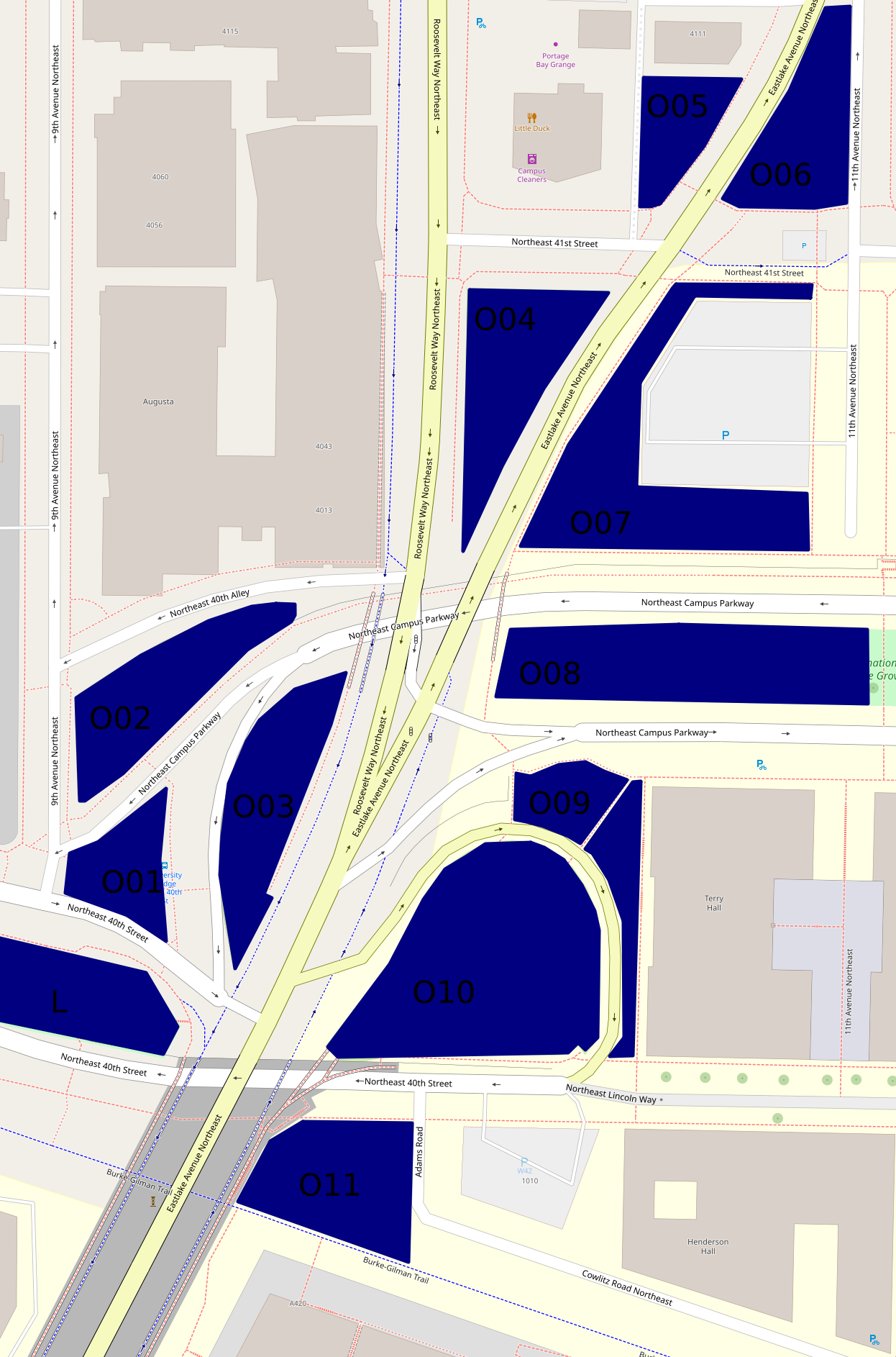
Besides Peace Park (L on the map, and covered in the previous part), there are eleven other green areas that form an only mildly discontinuous belt around and north of the place where the University Bridge joins North Seattle's street grid.

Here's a map, which differs somewhat from the map up above as well as being on a much larger scale:


The hill off the bridge (O10 on second map)

This entirely grassy hill more or less between 40th St and Eastlake Ave has at its southern side a ramp off the bridge.  Of these areas, this was the first I visited on December 22nd, 2020.  But I'm choosing a photo taken October 29th:


The King County Parcel Viewer says that the northeastern part of this area, mid-right on that photo taken looking west, belongs to the university, the rest to the city (and probably specifically SDOT).  I have no idea why there's a crop circle in this land which isn't farmed.

The woods below the bridge (O11 on second map)

If I understand the parcel viewer correctly, this area is half university (east), half city (west).  It has a path between a very short Adams Road which I thought, when mapping northern West Campus, was a spur of Cowlitz Road, and the Burke-Gilman Trail.  This photo is from December 2020.


This woods appears to have been much used by homeless people.  Partly because of this, and partly because it's the least traffic-affected, most park-like, of these areas, I've taken more photos of it than of any of the rest, five versus one or two.  I'm surprised SDOT hasn't fenced it off too.  This photo is from October 29th.


The bus stop triangle (O01 on second map)

Behind the bus stop north of Peace Park is this small, path-broken woods.  It's between 40th St, 9th Ave, and two arms of Campus Parkway, and it's city-owned.  This photo, and all those until the last of these areas, are from October 16th.


Another wooded place (O02 on second map)

This one is between 40th Alley (according to OpenStreetMap), Campus Parkway, and 9th Ave, and is city-owned.


And another... (O03 on second map)

This one is between Campus Parkway and Roosevelt Way, and is also city-owned.


A grassy place (O04 on second map)

This is a triangle between Eastlake Ave, Roosevelt Way and 41st St.  It's university-owned.


And another... (O06 on second map)

This is a triangle, or really a series of triangles, between Eastlake Ave, 11th Ave, and the line of 41st St.  It appears to be city-owned.


A landscaped place (O05 on second map)

The land south of 4111 11th Ave NE, between Eastlake Ave and an alley, turns out not to belong to that building's owners, but to the university, at least according to the parcel viewer.  It's landscaped pretty fully, with trees, large stones at its borders, and slopes, a rather lovelier deterrent to campers than most I've seen.


And another... (O07 on second map)

This is the landscaping around a parking lot, between Eastlake Ave, 41st St, 11th Ave, and Campus Parkway.  It's university-owned.  From its southwest corner, the parking lot isn't even visible.


A block of Olympic Vista (O08 on second map)

Olympic Vista is the park that consists of the boulevard islands in the street Campus Parkway.  All clear?  I'd assumed Olympic Vista was university property; at least two aspects of its landscaping suggest the university's intervention; but according to the parcel viewer, it's all city land.  Anyway, what with all the grassy areas east of Eastlake, the woods at this end of Olympic Vista rather stand out.  However, I'll cover them with the rest of the park, in the next part, tomorrow.

Borderlands (O09 on second map)

Most of the land between Campus Parkway, Eastlake Ave, the road between those, and the university's Terry Hall is more or less green.  In the second map, it's split by a path.  That path is really there, and this area is grassy on the north side, landscaped on the east side.  Photos taken October 29th.


The University of Washington Farm at Mercer Court (P on first map)

That's the best name I can come up with for a park that's actually a bit bigger than the farm's fields.  Essentially all the land between the buildings of Mercer Court, a set of student apartment buildings, except building A to the north, is park.  Each space - between buildings B and C, C and D, and D and E - has the same series of elements:  fields from Pacific St to the stairs, a landing with more fields, more fields on top, then bushes, then benches.  From those benches, if not for the bushes, Portage Bay could probably be seen.  What differs is mainly the relative size of these elements.

Oh, the UW Farm?  It's real, it grows a few tons of food each year, and it supplies that food mostly to other places on campus but to some extent to outsiders as well.  (It offers various CSA plans, some of which appear to be sold to the public but not others; it supplies food to many campus venues and two I can't identify; it gives food to the UW Pantry, the University District Food Bank, and Fare Start.)  This is one of its main locations; we'll meet the other in East Campus someday, and a small new one in (north) Central Campus probably sooner, dear Diary.

I don't see a way for someone who can't handle stairs to get to the fields on the landings at all.  Also, I'm pretty sure getting to the stairs involves gravel paths in all three spaces.  (EDIT November 15:  Wrong.  In the western third, between buildings D and E, one can walk the whole way on pavement.)  So this park is relatively inaccessible to mobility-impaired people, such as me when in December 2020 I was pushing a cart; I took two not very interesting photos and went on.  So my single biggest concern on October 29, when I went back to the parks of that December 2020 hike, was this park.  I took photos on October 29 of each of the three bench areas, each of the three landings, and each of the three Pacific St views.  Fortunately, my preferred photos illustrate all three categories and all three spaces.


The benches photo is from between buildings D and E, the landing photo between buildings C and D, and the Pacific St photo between buildings B and C.

Well, that's all I have for you today, dear Diary.  Tomorrow I hope to tell you about Olympic Vista and the itty bitty parks near it, and then on Tuesday the buildings of southern West Campus.  But we'll just have to see.  Have a good night and good hours of days and nights until we meet again.