Showing posts with label public-private. Show all posts

Friday, September 4, 2026

Building a Baseline, part IV: Around Seattle's northwest corner

Dear Diary,

This part concerns three places, one of which I've never seen, and a different one of which is quite far from the other two.  So it's a dubious gathering.

But that's what these hikes' version of "inconvenients" are like.  In part II of this page, I wrote "Most of North Seattle is, on the maps I drew, full of interesting places to go."  The first day I tried to visit 20 destinations, September 1st, only four were left for Northgate.  (I then ruled one out of that part.)  So I looked for isolated destinations that wouldn't take bites out of the main web, and this part and the next, about Bitter Lake Reservoir, are examples.  (Northgate and Bitter Lake itself are bites out of the main web, but ones I felt relatively confident about.)

Here's the usual OpenStreetMap map:


So let's go!

Unidentified exclusive park (A on map)

There's a vacant lot, about fifteen acres in size, just north of the City of Seattle park, seven acres, Llandover Woods.  This vacant lot goes up to the city's border with Shoreline.


From the website of the owners, The Highlands, I'm fairly confident that this lot is, or is part of, a park.  That website doesn't name most of their extensive parks, and specifically not this one.

The Highlands is a gated community in Shoreline; this may be their only Seattle property.  One gate, in the form of a guard station, is visible from near Llandover Woods's entrance:


I'm afraid, dear Diary, that this is the first of the five parks getting their first descriptions in your pages that I mentioned.  But the best of the five is also in this part.  If this park has an address, I don't know it; the King County Parcel Viewer doesn't assign addresses to vacant lots.

Llandover Woods (B)

This is a woodsy park at 14499 3rd Ave NW, with trails and distinctive benches as its main amenities.  I've only discussed it with you, dear Diary, once, I think, in November 2020's "Top of the City, part III".  Unaccountably, considering that I would soon start writing about topography, I left out any reference to its spectacular relief.  (Basically, Llandover Woods, and for that matter Llandover on the Sound, the home owners' association, are on the slopes of coastal cliffs rather like those I described, not very well, in "Land and Water in North Seattle, part II: The Lake City Coast".)


There are two main trails, one of which marches efficiently from entrance to exit.  The other wanders more, has less official trails branching off from it, and is simply more fun.  Unfortunately, to make that latter trail work, they had to include stairs.


I did have fun there, and will try not to let six more years pass before I visit again.

Dunn Gardens (C)

This is a garden property that boasts of being the only publicly accessible example in Washington of a garden designed by the Olmsted brothers, the same people who designed Ravenna Boulevard.  It contains two (not very) private residences, and I ended up leaving by the driveway of one.

Its management has a very clear idea of who its main audience is (unlike me!), and the gardens' home page brags about their "all terrain wheelchair".

This is a privately owned park, part owned by the E. B. Dunn Historic Garden Trust, and part by the owners of the private residences.  And I took way too many photos to fit into this part, and liked the place enough that I want to give it its own page anyway.  So that's the last page I hope to write in you tonight, dear Diary.

This much more teaser, though:

Baseline for the northwestern corner of Seattle:

Dunn Gardens - One water fountain, running, and with the sort of water delay that fountains at Northacres and Cal Anderson parks have.  They bought it expecting it to run all year, and it looks like they got their money's worth.  Two non-gendered single user stalls, one wider than the other and presented as accessible.  All at least notionally paywalled.

I hope to get back to you soon, dear Diary.

Thursday, September 3, 2026

Building a Baseline, part III: Around Northgate

Dear Diary,

Well, I've finished the spreadsheet, uploaded it and shared it, so if I'm extremely lucky, people can now read or download it from here:

Google Drive link 

The total places I'm trying to visit turn out to be 500 - 323 city owned, 126 from OpenStreetMap, and 51 from The Emerald City Resource Guide

Today I don't think I can hike at all; but I can write.  And it turns out, there's a lot of news - to me, at least - in this area.  Here's a map.  I should probably tell you, dear Diary, that while I'm writing on my phone, I'm doing most of the work on my Windows laptop.  (My Linux laptop, on which I'd written you for years, is broken.). So this map represents a learning curve.  It is, of course, based on OpenStreetMap.

I covered several of these places in two parts in the third series of regional hikes in May 2021, so I've felt free to not photograph everything this time.

And now to start, in hiking order:

August 4

The news didn't really start this day. 

Thornton Creek Water Quality Channel (A on map)

I've shown you this Seattle Public Utilities park, I think, several times now.  Its address is 330 NE 100th St, and it stretches north to 103rd, near the exit there from the transit station.  It's in the Thornton Place apartment complex.

This time I hiked all the trails, as promised, and found neither restrooms nor water fountains.  It does have lots of benches, and, being an SPU park, lots of explanatory signs.

So I just settled for two photos.  One sign, and one glimpse of the reason the park exists, the South Fork of Thornton Creek.


Maple Leaf Community Garden (B)

This is one of the two P-patches in North Seattle owned by the Seattle Department of Parks and Recreation.  Its address is 529 NE 103rd St.  It's really a P-patch, a shared garden, but has an interesting tower, which I've shown you before, dear Diary, so this time I settled for photographing a bench with words written on it whose sententiousness pleased me.


Beaver Pond Natural Area (C)

OK, this is sort of news.  Years ago, dear Diary, I told you about this park, and then told you I'd gotten it all wrong, and the park was actually twice as big as I'd thought.  So it's extremely humiliating to discover that I was wrong then too, and the park is actually four times as big as I'd originally thought, twice as big as my revised version.

As a result, I have much more to tell you, dear Diary, about this park, than will fit here, so see a separate page coming soon.

I should say, though, that my main memory of this park was that it had lots of litter, and I didn't find any this time.  Also, the part I found first is the basis of its address, 10300 5th Ave NE.  Right next to a bus stop.

Northgate Park (D)

I thought, on August 4th, that the water fountain in this quite bland lawn of a park (address for both the park and the community center below:  10510 5th Ave NE) was the only example of our core topic, water fountain or restroom, that I'd find in this area.  This turned out to be wrong.  That said, the fountain was running, and I refilled my bottle there.

Northgate Branch Library (E)

I verified that the restrooms were open and the water fountains running, and that was that.  Address:  10548 5th Ave NE.

Northgate Community Center (F)

The story is pretty much told in the recent part in "Under Construction".

Hubbard Homestead (G)

This one, too:  link.  With a link to a whole part about this park in the regional hike of May 2021.  Address:  11203 5th Ave NE.

Victory Creek Park (H)

The reason I had to tell you, dear Diary, about the strange absence of litter in Beaver Pond Natural Area, is the severe contrast with Victory Creek Park, whose address is 1056 NE Northgate Way.

This is a very weird park.  It's a few benches and a former playground versus a daylit creek, the titular one, a tributary of the South Fork.  As I mentioned in the "Under Construction" page about Hubbard Homestead, it's adjacent to a QFC, usually entered through the parking lot.  I'm not sure whether to admire Parks for sticking to the fact of the daylit creek, or pity the neighbours who might want a more conventional park.  But I can't help wondering whether the litter says what it isn't politically correct to say out loud, that nature isn't the only thing people want out of parks.

At any rate, I made one attempt to photograph the creek, and took a photo meant to illustrate what it's like walking this park's trails.


August 5

The news starts here. 

Victory Creek Confluence Natural Area (I)

This is one of 2 1/2 Seattle Parks parks in North Seattle that I couldn't find in 2020-2023, as I'm sure you, dear Diary, remember.  Well, this time it was easy.  The King County Parcel Viewer steered me right there, and the address, 1039 NE 108th St, slots this tiny park in right where it should be, between 1019 and 1223.

See, it's the property on that block that isn't just fenced, it's walled:


I trespassed a bit onto 1223's lawn to find the reason.  Someone had littered a boat there!

August 7

This was the day I spent on Beaver Pond Natural Area.

August 18

Northgate Mall's Central Park (J)

Over the years that Northgate Mall has seemed to consist mostly of construction fences, I've occasionally looked at the mall's  Central Park, but all I remember seeing was a concrete plaza where people were sitting on that trendy "bistro" furniture and presumably discussing shopping strategies.

This time, I decided I owed it to the mall, this odd neighbourhood's centerpiece, to look more carefully.  And lo and behold, one level down, there's a small playfield, there was a girls' team practicing there, 

and what was that behind them?


Now, dear Diary, for good reason it's been an article of faith for me that privately owned parks in North Seattle just don't do plumbing.  But the surprises didn't end there.


Look, ma!  It is possible!  A restroom whose door opens to the outside, not just near Northgate, but actually in Northgate Mall!

Who knows?  Come the next pandemic, this restroom may be open.

Well, a lost park found, and a privately owned outdoor restroom, surprises enough, but there's one more to come.

September 1

King County Veterans Program (K)

On page 137 of The Emerald City Resource Guide, 8th edition, in the chapter "Veteran Services", we read:

Provides emergency financial assistance, housing system coordination, case management, social work, and education and employment resources.  Documents required include proof of service (prior or current) as an active duty or reservist member, documentation of King County residency, and proof of income eligibility for financial assistance. 

This program is at 9725 3rd Ave NE, not at all far south of the transit station, but an office building much too swanky to have sidewalks.

This occasions a certain amount of culture clash with some of the program's clients:


Northgate Station (L)

On September 1st, I bought my bus pass at Roosevelt Station, and then explored the station looking for restrooms, for practice.  So it was a welcome surprise to find the ones at Northgate Station, one of whose addresses is 100 NE 103rd St, the first place I looked.

And, yes, the rules were as I'd vaguely remembered:

But the surprise came after I'd put this phone away.  I saw a security guard escorting a customer or two, no surprise given that procedure, but all the guard seemed to do was push the door open.

That mezzanine is not really outside, but if Sound Transit has actually given up on keeping restrooms locked by default, a pattern that goes way back to before Sound Transit itself existed, to when there used to be token restrooms in suburban transit centres, that's very good news.

Anyway, no more surprises, just an SPU property not big enough to be one of their best.

Northgate Pump Station (M)

Near as I can tell, the only example of SPU park style here, at 400 NE 115th St, is a couple of big, old trees.

But that isn't nothing.

Well, dear Diary, that's my baseline for Northgate:

Northgate Park - running water fountain

Northgate Mall - triple water fountain, the parts for humans and dogs running, the part for bottles not running; gendered single user stalls open

Northgate Station - ungendered single user stalls apparently open, and you may rest assured I'll be checking further on that

Let me rest some before explaining to you my career of error about Beaver Pond Natural Area.  Happy times until then.

Monday, August 31, 2026

The Right to Roam, or the Wrong to Roam?

Dear Diary,

One of the three main sources on which I'm relying to plan my baseline hikes is a scan of North Seattle, last week, in OpenStreetMap, as constrained by the King County Parcel Viewer.  I noticed early on that most daylit creeks were on private land.  However, in the area between Carkeek and Golden Gardens parks, more or less the middle of western North Seattle, there were two creeks more or less in the middle of undeveloped streets.

So I began thinking of undeveloped streets as a gold mine of unrecognised public land, just waiting for publicity.

But around then, I started to accumulate evidence that even developed streets aren't public land.  For example, I downloaded block-by-block data on Seattle's streets, from a Seattle Department of Transportation GIS application, and in that enormous dataset SDOT claimed to own only 125 blocks.  It attributed 625 to Washington state's Department of Transportation, a scattering to other owners, and the vast majority to no owner at all.

I'll get to this question's answer below, but first I want to tell you, dear Diary, about a book I found while hunting for that answer.

This Land Is Our Land:  How We Lost the Right to Roam and How to Take It Back by Ken Ilgunas

Ilgunas previously wrote a book titled Trespassing across America, and this 2018 book is his attempt to provide the philosophical basis for the story that book tells.

A friend about as consistently right wing as I am left wing told me, long ago, that one of the Unabomber's main complaints was that he couldn't just go whatever direction he wanted, whenever he wanted.  I scoffed that he couldn't have grown up in forested land, to have such a silly view, and there the discussion ended.

But Ilgunas argues that property rights have, over the past two centuries, gone too far, and American Supreme Courts have been instrumental in this.  Some billionaires now own more square miles than some U.S. states occupy.  And "the right to exclude" has gone from being a far-fetched legal fantasy to being seen as central to the whole concept of property.  He notes that "No Trespassing" signs have a history, and it's a surprisingly recent history.

He acknowledges that a lot of countries share the American extreme view of property, but goes into detail about how Sweden has developed completely differently, and how both England and Wales, and Scotland, had more or less imitated the Swedes.

I can't help thinking Ilgunas knows his ideas have no chance here.  He explicitly mentions millions of homeless people, but never considers the implications for his dreams. 

The Wrong to Roam?

Ilgunas acknowledges that a lot of people dislike the phrase "the right to roam" as just as absolute as what it fights, and prefer something like "responsible access".

By no standard of responsible access is Seattle a good place to start roaming.  One of the key elements of responsibility is respecting the owners' privacy, and most lots in Seattle are much too small for trespassers to do that.  (Part of privacy, after all, is not just not being watched, but not having others obtruded on your own view.)

Washington state is also a lousy place to start roaming.  I don't know that shoreline access is really guaranteed by English common law, which some people who discuss these things say it is.  But Washington is distinctive in that, according to Bainbridge Island journalist Christopher Dunagan, neither the courts nor the legislature have ever specifically addressed the subject.

And then there's the answer to my original question.

Who owns Seattle's streets?

I had realised, by this time, that my searches were wrong.  Searching on 'streets ownership Washington', as opposed to 'streets ownership Seattle', got me promptly to a page from the Municipal Research and Services Center, one of the public/private organisations I told you, dear Diary, about in one of the library hours pages.  Which says something I'll get to shortly, but for now let's answer the question.

"Sometimes, the municipality will own the property on a public right-of-way.  Usually, however, the property owners next to the street own the property, which usually goes to the centerline of the right-of-way, and the municipality has secured the easement for public travel."

Two references follow.  I read one, Kiely v. Graves, which says over and over things like "when a dedication specifies that property is to be used as a thoroughfare, this is strong evidence of intent to grant only an easement.". Unanimously, per the Washington Supreme Court of 2012.

OK, so the other thing the MRSC said is, "If a right-of-way has not been opened and improved, the property owner can use it like they would the rest of their property.  However, they may have to stop using it if the right-of-way is opened and improved in the future."

Nope, no trove of little-known public property here!

Implications for the shoreline street ends

What led me to start writing this page in you, dear Diary, is that I was getting ready to add the shoreline street ends to the lists and maps, and I noticed again the lack of them in most of northwest Seattle.

At first I described the shoreline street ends as following clear rules, then I found lots of exceptions, and said no, they were just a land grab.  Now I'm beginning to think that while they were certainly a land grab, they focused on an old right Washington doesn't allow, shoreline access, and they almost certainly did have clear criteria after all.

There is no undeveloped street action north of NW 57th St on North Seattle's Shilshole Bay coast.  On the Parcel Viewer, if you've panned it south along that coast, it's uninterrupted by any of the lines meaning public right of way, until 57th, where those lines jump out at you.


Which is, if I'm right, the criterion the city used.  Streets that stopped while their right-of-way easements continued to the water.

I'll let you know, dear Diary.  In the meantime, I have lots more mapping and listing to do, so I can hike tomorrow.  Happy days and nights until I start telling you about that, dear Diary. 


Thursday, November 17, 2022

Buildings of the UW's Seattle Campus, part IID: West, summary and prospects

Dear Diary,

It isn't easy to count the University of Washington's buildings, because one has first to define what one means by a building.  For present purposes, let's pretend that I visited 61 buildings in UW's West Campus and north and south of there, in the area from I-5 to 15th Ave NE and from the water to NE 45th St that I'm calling Brooklyn (well, OK, four are actually north of 45th).  This is more than I expect to list in East or South campuses, and is well over half the number in Central Campus.

Unlike Central Campus, but like the other two, very few of these buildings, most of which are publicly owned, are open to the public.  And fewer still offer public restrooms.  I don't need a whole alphabet for them.  And I don't really need another map for them, although this part includes both building and park maps anyway for completeness's sake.

The present

Here are the buildings that offer publicly reachable restrooms in this area, with the best information available to me about their hours:

  • Hours not posted:
    1. University of Washington Medical Center Roosevelt Building 2 - 7 A.M. to 6 P.M. weekdays [1]
    2. University of Washington Police Building - 9 A.M. to 4 P.M. weekdays
  • Posted against the public:
    1. Social Work Building (southern half) - 7:30 A.M. to 6 P.M. weekdays
    2. Condon Hall - 7 A.M. to 6 P.M. weekdays, if one can find an unlocked door
    3. Fishery Sciences Building - 7 A.M. to 5:30 P.M. weekdays
    4. Fisheries Research and Teaching Building - 7 A.M. to 5:30 P.M. weekdays
    5. Marine Studies Building - 8 A.M. to 5 P.M. weekdays
    6. John M. Wallace Hall - 8 A.M. to 5 P.M. weekdays
  • Public restrooms with clear hours:
    1. University Book Store - 10 A.M. to 6 P.M. Mondays through Saturdays, noon to 4 P.M. Sundays
    2. Schmitz Hall - 8 A.M. to 5 P.M. weekdays
    3. Drama Scene Shop - 9 A.M. to 6 P.M. weekdays
    4. Gould Hall - 8 A.M. to 6 P.M. weekdays

[1] - I clicked through 24 Web pages of clinics at UWMC - Roosevelt. The Exercise Training Center is open until 6 P.M., and the Spine Center and the Dermatologic Surgery Center open at 7 A.M.  The last-named is in Building 1, which doesn't have public restrooms, but the other two are in Building 2, which does.

Did you notice something, dear Diary?  Weekend hours are only at the Book Store.  And there are no evening hours, nothing after 6 P.M.

I wasn't familiar with most of these buildings before the lockdown, and not all of their previous hours are documented online (for example, the UW's pages for classroom buildings, such as Condon Hall, have never included hours).  But let's see how many are documented.  I already referred to the Book Store's mildly longer hours, three parts back.  The Exercise Training Center in UWMC-Roosevelt building 2 is recorded to have been open until 7:30 P.M. Mondays through Thursdays as recently as December 2019.  The UW Police Building's hours aren't much changed from January 2020.  The Built Environments Library in Gould Hall used to be open until 8 P.M. Mondays through Thursdays, and 1 to 5 P.M. weekends, as I noted in the academic libraries page.  A 1999 UW Daily article ("updated" in 2015) gives the same hours for Schmitz Hall as it's keeping now.

Let's also look at the nature of the obstacles.  At the Social Work Building and John M. Wallace Hall, signs on durable materials announce the public's unwelcome, although in each case signs on paper suggest otherwise.  At the other buildings, the barring signs are themselves on paper.  None of these buildings have the kind of painted-on-glass "Public Keep Out" notices common at the West Campus dorms.

So my best guess is that West Campus and its northern environs have never really been a good place for a homeless person to try to spend a rainy day, but have probably gotten somewhat worse since the pandemic.

I also don't know how long UW has been lecturing the residents of West Campus that they should fear their non-UW neighbours.   All those painted-on "Keep Out" notices suggest this pattern is longstanding.  At least one person other than me who disagrees with the message has been on West Campus recently, though:


The future

The day I photographed those posters (but didn't see, haven't seen, at all the one that seems to have fallen from the top), I also (well, that evening) photographed another poster, on 15th Ave somewhere south of Campus Parkway:


"Be a World of Good".  Comparable ambition to the previous slogan, "Be Boundless"; but decidedly more interested in generosity.

I was born to a geneticist and raised by her and my father, who, I've already told you, dear Diary, was an epidemiologist.  I grew up two blocks from a university library, and used to stay there past my bedtime.  The years I was homeless here are hardly the only years I've spent largely in university libraries.  I'm not trying to grind an anti-intellectual axe here.  It's just that I consider myself capable, given the atmosphere in which I grew up and have lived, of distinguishing a university's good deeds from its less good (let alone its evil) ones.

While looking for a name for what I eventually called the Fishery Sciences Courtyard, I came across a reference to it in the previously mentioned environmental impact statement for the UW's current Seattle Campus Master Plan (327-page PDF).  This eventually led me to a whole page of planning documents.  And one thing that's really up front in those documents is that the UW expects to build a lot in the next decade or so, and fully half of that building is planned for the West Campus.

Part of what that's about is that the UW is planning, although not in a rush, to get rid of most of its surface parking lots.  (The current occupation of lot W35 by the Haring Center's school can be seen as a trial run for this.)  Much of the Seattle campus is given to such lots, so that gives it lots of room to build.  I expect many of the buildings will include underground parking, but also, it turns out UW is subject to a cap on certain categories of parking.  See, the Master Plan is actually an agreement between the university and the City of Seattle, and one component of that agreement for some time now has been this cap.  And this time, the cap is being lowered, from 12,000 to 9,000 spaces.

So that's some of it, but there are much bigger surface parking lots in Central and East campuses than anywhere in West Campus.  The main thing is that the university has asked for, and been given, much higher height limits on much of West Campus than it had hitherto obeyed.  I mentioned that many of the buildings of West Campus weren't originally built for or by the university; they're also rather short, as are many of the buildings further north, outside the Master Plan's boundary.  So the UW can solve two problems at one stroke by tearing those inherited buildings down; it can get purpose-built university buildings, and it can get them taller.

Of the buildings I've discussed, Schmitz Hall, the Transportation Services Building, Condon Hall, Henderson Hall, the Child Center West Campus, the Southwest Maintenance Building, the Brooklyn Trail Building, the Ethnic Cultural Center Theatre, the Community Design Center, the Drama Scene Shop, the unnamed buildings at 3935 and 3939 University Way, the Purchasing and Accounting Building, the UW Lock Shop, the Northlake Building, Stevens Court, John M. Wallace Hall, the Fishery Teaching and Research Building, the Marine Studies Building, the Portage Bay Garage, the Child Center Portage Bay, the Ocean Research Building, and the Washington Sea Grant Program buildings are all candidates for demolition.  24 of the 61.

Also, the following parks I've described to you, dear Diary, will be affected by this plan.  H (805 NE Northlake Place), O07 (another landscaped area near the University Bridge head), R (Transportation Services Building Courtyard), T (Condon Hall Courtyard), and V (Child Center West Campus playgrounds) are all candidates to be built over.  N (Burke-Gilman Trail under the University Bridge), Q (Gould Park), Y (Fishery Science Building Courtyard), and Z (Burke-Gilman Trail near Brooklyn Ave) are all to be expanded, but are likely to change significantly in the process.  This is why I don't know, in particular, whether Tikvah's Garden will survive, to whatever extent it survives now.  It's to become part of what the Master Plan sees as the first really good West Campus park, the West Campus Green.  (Sakuma Viewpoint is perennially tugged between West and South campuses, so doesn't count.  Of course, the block the West Campus Green is to be on, the Fishery Science block, is also perennially tugged between those, but maybe a little less so.)

The UW also agreed to a cap on construction.  That's what the 50% refers to.  It gets to do net 6,000,000 new gross square feet of construction, and has agreed that 3,000,000 of those should be in West Campus.  The Master Plan itself insists that much of what a university does not only is inscrutable, but shouldn't be scrutinised at all.  So it doesn't say much about in what order this very tall order should be executed.  However, a different document, the 2018 West Campus Guidelines (95-page PDF), provides some hints.  On its page 73 is a map, distinguishing two ten-year tiers for the work (five buildings in the first tier), and also giving what sure looks like an exact order for the buildings to be built.  The Master Plan is of course correct that the university isn't committed to any particular order, but I suspect that left to its own devices, page 73 shows what it thinks might work best.

The building marked 1 on that map is the one to go in the southern half of the block between 40th St, University Way, the Burke-Gilman Trail, and Brooklyn Ave.  At this time that half-block is occupied by the Purchasing and Accounting Building (all of whose departments are still working from home), parking lot W12, and the UW Lock Shop, which is preparing to move:


I think it's a reasonably good bet that that building, labelled W27 (but a building, not a parking lot) on the map, really will be first.

And that triggers something else.  On page 240 of the Master Plan, we find what looks very like contract language:

Over the life of this CMP, the approximately
4-acre area designated as the “West Campus
Green” shall be reserved for open space,
except that minor structures supporting
the open space function are allowed.
Structures and improvements required for
utility infrastructure are also allowed. A
design and implementation plan for West
Campus Green and West Campus section
of the continuous waterfront trail shall be
completed by the earlier of: the time 1.5
million square feet of net new development
in West Campus sector is completed; or the
time the University submits its first permit
application for development of Site W27, W29,
W33, W34, or W35. A concept plan for all
three sections of the continuous waterfront
trail—West, South, and East—shall also be
completed by that time. The concept plan
for the continuous waterfront trail shall be
reviewed by SDCI for compliance with the
City’s Shoreline Management Master Program
and the University’s Shoreline Public Access
Plan. The continuous waterfront trail design
and implementation plan for the South and
East campus sectors shall include convenient
pickup and drop off facilities and signage
throughout the length of the trail that reflects
local Native American history. Construction
of the West Campus Green and the West
Campus section of the continuous waterfront
trail shall occur by the earlier of: completion
of 3.0 million gross square feet of net new
development in the West Campus sector; at
the completion of adjacent development sites
W29, W33, and W34; or the exhaustion of the
6 million gross square feet growth allowance.
In addition, as the University completes
development of Site W29, it shall complete
the “Plaza,” and as the University completes
development of Site W27, it shall complete the
“Belvedere,” both identified on page 98.

So basically, if the UW does start its West Campus remodelling at W27, it will deliberately be triggering various deadlines related to public open space.  (However, the first building in the numbered sequence to trigger the West Campus Green actually being built, which entails demolishing three not so very old, purpose-built buildings, is #5, W33.  So they aren't planning to force themselves to make that happen very soon.  Buildings 2-4 are between 40th St, University, the BGT, and 11th Ave.)

The Master Plan also promises that a whole lot of the new buildings will have "active edges".  Turns out an active edge can be almost anything - a classroom, for example.  But not an office.  So this isn't an outright promise that the university will have ground floor retail open to the public, say, let alone public restrooms, in the new buildings; but that's certainly the impression the more marketing-ish of the pages of the Master Plan try to convey.

Which brings me back to "Be a World of Good".  Which is the better deed?  To offer a bunch of parks, of which the West Campus Green is strongly hinted to get the park restrooms Fritz Hedges Waterway Park across the street didn't get [1], and then lock all the other doors?  Or to live up to the claims for "innovation" and "diversity" the Master Plan is full of, and reverse the recent trend of enforcing separation between town and gown with card readers?  I don't think the university, given the direction it's currently going, is even trying to live up to the spirit the Master Plan calls for, and sooner or later it's going to have to decide whether indulging fear is really the best it can do.

[1] Now we have a better reason than sloth or penury for the Seattle Department of Parks and Recreation's refusal to build restrooms at Fritz Hedges.  Future restrooms that someone else will pay for are always better than present ones that people can actually use.

The past

I plan, dear Diary, to publicise this part a little bit.  So I thought it would be helpful if I concluded it with references to the previous parts, both on the buildings of and near West Campus, and on the parks of Brooklyn.

"Buildings of the UW's Seattle Campus":

The final map:


"Six Hikes in Brooklyn":

The final map:


Also relevant:  "Academic Library Hours One Year Later, part I:  Public universities".

Dear Diary, in the next week I really should finish with the academic libraries, as well as start a really long Korean drama and look for work.  So you probably won't hear much from me until I finish at least one part of the academic libraries remaining.  Happy days and nights until then.


Tuesday, November 15, 2022

Buildings of the UW's Seattle Campus, part IIC: Southern West Campus

Dear Diary,

This is a story of vicious crime and moral turpitude.  Depending on whom you believe, I may have broken the law multiple times yesterday by photographing UW buildings' doorways.

First, though, the map.  You may have noticed, dear Diary, that I've been making the maps sort of cumulative.  The parks of Brooklyn, while numerous, just exactly fit into one alphabet, so I've made their map completely cumulative.  The West Campus buildings, on the other hand, are much more numerous, so while the colours and so forth have been adding up, I've had to use three separate alphabets as keys.  But this part is the last - for West Campus - in which I'll need to do that.


I've completed and corrected the depiction of roads named after counties of Washington on this version of the map.  Adams Road NE (where I previously had part of Cowlitz Road) and Adams Lane NE are in a sort of pastel yellow, and NE Pacific St is in a brick red.

Southern West Campus is, over all, the most campus-like of the parts of West Campus.  There's lots of greenery.  Several roads lack both traffic lights and sidewalks, and have little vehicle traffic not moving fast, although Pacific St, in particular, has plenty of lights, sidewalks, and faster vehicles.

OK, now for the true crime story of my evil photography.  The photos for buildings A-C, J and L-O were taken November 3; those for buildings D-I and K were taken yesterday, November 14.  (I also took a few photos for apartment complexes H and I Wednesday, November 9, and a few for buildings D, N and O today.)  They're all in a folder on my Google Drive.

Red - Locked

Child Center Portage Bay (A on map)

Address:  3745 15th Ave NE

The other child care building on West Campus, after Child Center West Campus in the last part.  Of course it's locked.  This one, unlike the university's other child care centers, doesn't seem to have its own playground outdoors; I'm not sure how big it is indoors, because it's basically carved out of another building which I'm treating separately, the Portage Bay Garage (K on the map and below), but it certainly could be big enough to have a playground there.  It's also about a block from each of the four southwestern parks of Brooklyn, one of which presently includes a locked playground.

Washington Sea Grant Program (B on map)

Addresses:  3716 Brooklyn Ave NE and 3710 Brooklyn Ave NE

The office is in 3716 Brooklyn.  It carries an hours sign of weekdays, 8 A.M. to 5 P.M., but is locked.  (When I tried the door, back in October, though, this was one of the buildings from which someone came out to ask why I was there.  So someone pays attention to that locked door.)  There are lots of other doors on both buildings which I assume lead to individual grantees, and not restrooms at all; they have no signage of the kinds I looked for, and I tried none of their doors, which I assume are all locked most of the time.

Ocean Research Building (C on map)

Address:  3718 Brooklyn Ave NE

Again, an hours sign saying weekdays, 8 A.M. to 5 P.M., on locked doors.  This building is apparently home to the fund-raising office (currently named Advancement Team) of the College of the Environment.

Benjamin D. Hall Interdisciplinary Research Building (D on map)

Address:  616 NE Northlake Place

Named after:  Benjamin Downes Hall, 1932-2019

This is where my infamous career of photography and thumbing my nose at the law was first brought to light.  I started with what I'd considered the building's front door, on Northlake Place.  As I turned toward Pasadena Place, I passed a man with a dolly that had various boxes on it.  He was about my age.  When he saw me, he asked what I was doing there.  I replied that I was taking photos of doorways for my blog, that is, you, dear Diary.  He informed me that photographing UW buildings is against the law.  "Buildings?  From outside?"  "Just look at the website."

(Digression:  Last night I did so.  I couldn't find any such policy.  Maybe I really am eight years old, just as that UW PR guy thought I was, but my birth certificate disagrees with that.)

I replied that I'd been posting such photographs for a week and hadn't heard from any lawyers.  He then left me alone until I'd taken all my photos of the doors in the loading dock, then informed me that I couldn't "go wandering around in here".

Well, he was more or less right about that.  Maybe there is a policy somewhere that says this building's loading dock area is off limits to public pedestrians, though I didn't see a sign there.  But in any event, all the doors are locked.

(Later correction:  Indeed there is a sign, although it's such that only people to whom it doesn't apply are likely to notice it.  The loading dock area is normally held closed by a gate.  A card reader is adjacent to it to open that gate.  And on that card reader it says:


"Not for pedestrians".  That's the gigantic sign that's supposed to tell people not to walk around in the loading dock area.)

I don't know whether that man was a delivery guy or a tenured professor, but I do know that at the University of Washington, interdisciplinary researchers, perhaps to prove they're just as good as the more common intradisciplinary kind, don't want the public visiting.  In particular, there isn't even an hours sign, except the one at the loading dock for delivery guys.

Optical Remote Sensing Laboratory (E on map)

Address:  668 NE Northlake Way

I was wrong, dear Diary, in the preface to this page.  UW doesn't have a wind tunnel.  It has the one I knew about and also the one in this building, which makes at least two.  This building isn't mapped as part of West Campus but south of it, and is privately owned and pays property taxes.  It doesn't have any door signage at all.

Publication Services Building (F on map)

Address:  3900 7th Ave NE

This building actually hosts a variety of operations, notably UW Recycling and something managementy called UW Lean.  But it's primarily about pieces of paper.  Someone has bindery equipment there; "Creative Communications", an important part of UW marketing, is there; and "Mailing Services" is there.  Unsurprisingly, every locked door carries the same slogan:

"Building for Official University Use Only".

Northlake Building (G on map)

Address:  814 NE Northlake Place

This building belongs to Facilities Services, specifically the Building Services and Custodial Services parts of it, although the Applied Physics Laboratory has some space and its own door there.  Again, no surprise that it's locked.

Mercer Court (H on map)

Addresses:  3925 Adams Lane NE and 3927 Adams Lane NE

Named after:  Asa Shinn Mercer, 1839-1917

This apartment complex houses both undergraduates (in buildings A through C) and graduate students (in buildings D and E), mostly in multi-person apartments; I don't understand the lease terms of this complex or the next one.  We've already encountered Mercer Court's surroundings as a branch of the UW Farm, which has its "clubhouse" on E's bottom floor.  Other things multiple buildings have include bike storage space and music practice rooms.  Only building A, on the north, has the kind of ground-floor retail found in the dormitories proper further north:  it has a currently closed branch of the same Husky Grind café as is open in Alder Hall up there. [1]  It also has a "Graduate Student Learning Center", open only to graduate students.

I photographed the doorway of one of the music rooms.  My phone did the thing it sometimes does of presenting red as green.  The rooms are in fact locked, with red lights on their card readers.

[1] One thing that annoys me about these closed sites is that they all have signs in their doors saying they'll be re-opened in phases during the 2021-2022 academic year.  Can't anyone even bother to open the doors and change the signs once per year?  What if there were a gas leak in the interim?

Stevens Court (I on map)

Address:  3801 Brooklyn Ave NE

Named after:  Isaac Ingalls Stevens, 1818-1862

Stevens Court, whose apartments are open to both undergraduates and graduate students, is very unlike the relatively high-rise dorms and apartment buildings elsewhere in West Campus.  Each unit appears to have its own entrance from the outside, up a stairway as necessary.  The surroundings are rustic rather than paved (or farmed).

That doesn't mean Stevens Court is free from the fear that's inculcated into West Campus residents.  Far from it.  I found a poster area that had not only the "Safety" poster I abused in the previous part, but also this:

Housing and Food Services at least had the decency to put "Get to know your neighbors" first, but 2nd and 3rd reiterate the equation of non-university people with Bad Things.

Anyway, what with all the rusticity, Stevens Court doesn't have ground floor common areas.  Instead it has building H, which appears to be entirely common areas.  (It's the small building toward the east side of the court.)  Interestingly, a lounge in building H appears to be open to some conference attendees, who are admonished similarly to how more lastingly homeless people are:


But the evidence that I really am a hardened criminal came a little later in my photos:


"Use of the outdoor areas of this apartment community are [sic] restricted to residents and authorized personnel."  I bet the guy I met at Benjamin D. Hall wishes such a sign applied to the Pasadena Place sidewalk, too!  Anyway, it's a good thing I decided the Stevens Court courtyard doesn't need to be mentioned as a park, since it's apparently yet another university space from which the public is barred, in words and perhaps sometimes in deeds.

Orange - Unlocked, but no public restrooms

Agua Verde Building (J on map)

Address:  1303 NE Boat St

This building holds the Agua Verde Paddle Club and the Agua Verde Café.  It does not, however, as I already pointed out in this page's preface, hold any public restrooms.


Portage Bay Garage (K on map)

Address:  3740 Brooklyn Ave NE

Um, duh, it's a garage.  I didn't actually investigate this building even closely enough to figure out how much of it the Child Center Portage Bay (A on the map and above) occupies, certainly not closely enough to say whether it includes public restrooms, but really, what are the odds?  In any event, visitors are strongly (though not at all clearly) warned off:


Green - All good except we aren't wanted

This is as high as the buildings of southern West Campus go, dear Diary.  There are no postcard shots of buildings brave enough to admit the public in this part.  These buildings all appear to belong to the School of Aquatic and Fishery Sciences, part of the College of the Environment; beyond that, I have only limited information on which buildings hold what.  (Locked buildings B and C above probably have the same ownership.)

Fisheries Research and Teaching Building (L on map)

Address:  1140 NE Boat St

I found one of the four doorways of this building without the sign "This building is open to University of Washington students, faculty, staff, and invited guests only."  Its posted hours are 7 A.M. to 5:30 P.M. weekdays.

Marine Studies Building (M on map)

Address:  3707 Brooklyn Ave NE

I found one of the four doorways of this building with that sign.  On my first survey of this area in October, I also found a sign at that door saying the restrooms were out of order.  Now, without that additional sign, somewhat trap-like.  Hours, 8 A.M. to 5 P.M. weekdays.

John M. Wallace Hall (N on map)

Address:  3737 Brooklyn Ave NE

Named after:  John Michael Wallace, known as Mike, born in 1940

For this building, I do know of some specific tenants.  The Climate Impacts Group is here, as is the Cooperative Institute for Climate, Ocean and Ecosystem Studies, and also the Program in Environmental Studies of the College of the Environment.  The building's hours are 8 A.M. to 5 P.M. weekdays.  And the public isn't wanted; it says so, clearly, on each doorway.


Now, this is only to be expected.  After all, Seattle routinely - practically every month - churns up violent mobs howling for the blood of climatologists, right?

What's that you say?  We don't?  Gosh, then I wonder why the building isn't open to the public.  I wonder if the weird phrasing offers a clue.  "Building Restricted to U of W Faculty, Staff, Students and Authorized Account Holders".  For whom does the climate authorise accounts?  Furthermore, at least two of the doors have card readers, which I found green.  Wouldn't it be more effective protection for our desperately needed climatologists if the card readers were active?

Curiously, this building used to be the Academic Computing Center.  That's still its acronym-like code, ACC.  I dare say that in fact, the building used not to be open to people who couldn't use the computers there, and those signs have just been preserved in the building's new existence because it's always wasteful to throw away a sign that says "No public restrooms".  After all, think of all the children in Third World countries who grow all the way to adulthood without a "No Public Restrooms" sign of their very own!

That would also help explain why Wallace Hall has other sorts of signs.


I mean, if it's wasteful to throw away a decades-old sign, how could it not be wasteful to throw away one that's just a year or two old?  So at Wallace Hall, again at all three doors, COVID-19 is still governing building hours.

Nevertheless:  Which is it?  If a homeless man is observed wandering in and using the restroom during the hours that outdated sign advertises, without causing any other trouble, should he be prosecuted for it or shouldn't he?

I'm not sure how much Wallace Hall is a trap, how much it's just a museum.

Fishery Sciences Building

I am, however, absolutely certain that this building is a trap.  I don't know how often it snaps shut.  There was an event of some kind being prepared for when I visited on November 3rd; perhaps all the attendees were invited, and so were allowed to be in the building.  It's possible that I no longer get smelly and dirty enough to spring the trap myself, housed as I currently am.  But it's still a trap.

My evidence?  Well, Fishery Sciences has a lot of doors.  There are four on its south wall, in a row 12 34 two double doors.  There are eight on its southern east wall, strung 12  3  4  5  6  78, with double doors at the south and the north ends.  There's one on its northern east wall.  And there are at least three, depending what one counts as a door (here I mean one with a means of entrance), within the loading dock area on its west wall.

Fishery Sciences' hours are posted as 7 A.M. to 5:30 P.M. weekdays.

I tried every door around 4:30 P.M. today.  Here's what I found:


Here's what the signage on each door suggested I might have found:


Here's some signage from the northernmost double door:


"Welcome to Fishery Sciences".  And here's some from the loading dock door:


"This building is open to University of Washington students, faculty, staff and invited guests only."

Essentially, Fishery Sciences hides its warnings that it isn't open to the public on its loading dock and in an entrance hidden by shrubbery, meanwhile putting signs literally saying "Welcome" on its front doors.  And then it unlocks nearly all the doors, regardless of their signage.  "Never attribute to malice that which can be adequately explained by incompetence", it's said.  I'd like to know by what incompetence this state of affairs could come into existence.  It looks to me like a baited trap.

I'm sorry, dear Diary.  This structure for these parts is supposed to lead to happy endings, but it can't when there simply isn't anything happy to report.  Anyway, this is all for today, but I'm already ready tomorrow to write about the last four parks of Brooklyn.  Then the day after, I expect to sum up West Campus building hours.  From there, I'm not sure.  November 29th, I have to return SPL's copy of Lezlie Lowe's No Place to Go; there's a lot of work to do to re-start the downtown series, but that's one deadline for that work.  It's a bad idea to try to finish the academic libraries later than Thanksgiving, and I haven't even worked on them for over a week.  I also haven't watched any Korean dramas for months, and want to change that; and although the increasing certainty of a recession makes me increasingly certain that it's futile, I should also at least try to look for work.  So although I still expect to spend Thanksgiving weekend photographing the Central Campus parks (assuming it's legal to do so at that time), I'm not sure when I'll get back to UW otherwise.  I'll be astonished if the need to do so goes away in the next months.

But for now, good night, and I expect to see you tomorrow, dear Diary.


Saturday, November 12, 2022

Six Hikes in Brooklyn, part IV: Centre

Dear Diary,

This part concerns three places which I visited December 22nd, 2020; October 8th, this year; October 16th; and October 29th.  Two of the places are large and complex, divided into lots of parts, so this is a pretty photo-heavy part of this page.

Map:


The Burke-Gilman Trail and the Land under University Bridge (N on map)

Most of the Burke-Gilman Trail in this entire region - that is, from the water to NE 65th St and from I-5 to 25th Ave NE - is on land owned by the University of Washington.  However, the City of Seattle Department of Transportation owns the land under the University Bridge, including that chunk of the trail.

Before the pandemic, the part of the trail under the bridge was a favoured hangout for local teens.  Up the slope, locally north, there were and are concrete blocks attached to the concrete pavement; opposite that area is a flat place, with a sign saying "The Wall of Death", presumably referring to the difficulty of skateboarding the slope opposite.  On the rare occasions that I walked along that part of the trail, I sometimes stopped and put my satchels down on the dry parts of the flat area, but sometimes couldn't, because there were so many teens around.

During the early phase of the pandemic, a homeless encampment formed in that flat place.

By December 2020, that encampment had already been swept:


And a fence put up.  That fence is still there:


Dear Diary, I've recently been reading Skid Road:  On the Frontier of Health and Homelessness in an American City by Josephine Ensign, Baltimore:  Johns Hopkins University Press, c2021.  This is not actually a history of homelessness in Seattle, as a review had led me to believe; Ensign, herself a nursing professor, is too interested in the history of health care for the homeless, as her subtitle already makes clear, to give anything like a full account of the broader history.  But she does make it clear that Seattle has always had homeless people.  So those who have claimed in recent years to be trying to end homelessness here are struggling against history.

But I've had a great idea.  A way to really end homelessness in Seattle.  All we have to do is fence off all the public property.  Not just this flat place where some homeless people recently had the audacity to camp, but the whole trail.  All the sidewalks.  All the streets.  Every bit of it.  I'm quite sure that by the time the job was done, there would be no homeless people left in Seattle.

Of course, nobody else would be alive here either.  I think the decisive moment would come when the city's water supply shut down because the people trapped in the relevant places starved.  After that, the end would come in a few days.

But isn't that a small price to pay, to solve a problem that's already lasted nearly two centuries?

Unfortunately, SDOT hasn't yet tried to go that far.  The Wall of Death itself, as opposed to its sign, remains open:


though I would imagine some skateboarding moves could be difficult with that fence in the way up top.

One thing that has changed is that a graffito I saw in December 2020 is now gone:


Areas around University Bridge (O on map)

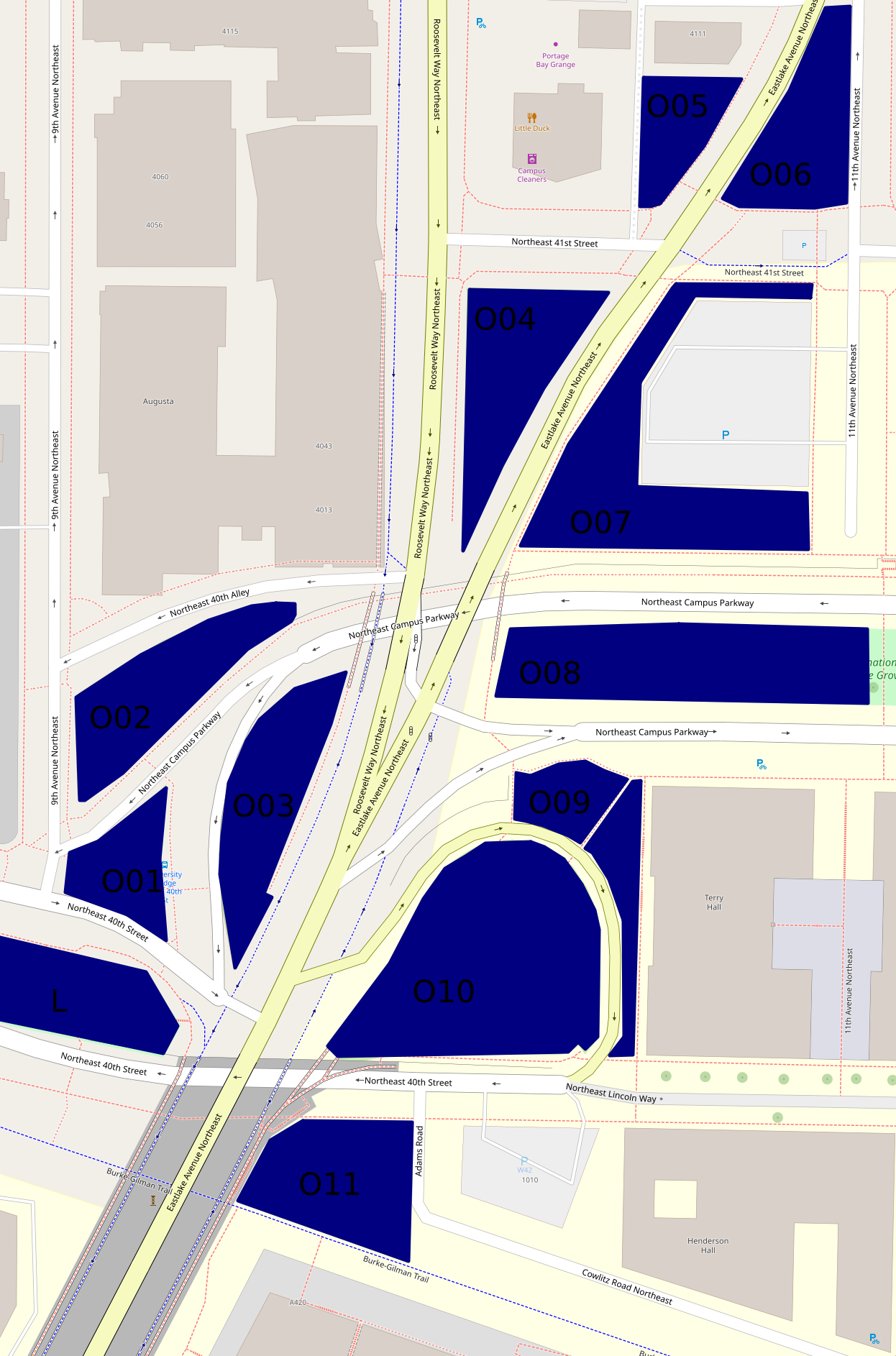
Besides Peace Park (L on the map, and covered in the previous part), there are eleven other green areas that form an only mildly discontinuous belt around and north of the place where the University Bridge joins North Seattle's street grid.

Here's a map, which differs somewhat from the map up above as well as being on a much larger scale:


The hill off the bridge (O10 on second map)

This entirely grassy hill more or less between 40th St and Eastlake Ave has at its southern side a ramp off the bridge.  Of these areas, this was the first I visited on December 22nd, 2020.  But I'm choosing a photo taken October 29th:


The King County Parcel Viewer says that the northeastern part of this area, mid-right on that photo taken looking west, belongs to the university, the rest to the city (and probably specifically SDOT).  I have no idea why there's a crop circle in this land which isn't farmed.

The woods below the bridge (O11 on second map)

If I understand the parcel viewer correctly, this area is half university (east), half city (west).  It has a path between a very short Adams Road which I thought, when mapping northern West Campus, was a spur of Cowlitz Road, and the Burke-Gilman Trail.  This photo is from December 2020.


This woods appears to have been much used by homeless people.  Partly because of this, and partly because it's the least traffic-affected, most park-like, of these areas, I've taken more photos of it than of any of the rest, five versus one or two.  I'm surprised SDOT hasn't fenced it off too.  This photo is from October 29th.


The bus stop triangle (O01 on second map)

Behind the bus stop north of Peace Park is this small, path-broken woods.  It's between 40th St, 9th Ave, and two arms of Campus Parkway, and it's city-owned.  This photo, and all those until the last of these areas, are from October 16th.


Another wooded place (O02 on second map)

This one is between 40th Alley (according to OpenStreetMap), Campus Parkway, and 9th Ave, and is city-owned.


And another... (O03 on second map)

This one is between Campus Parkway and Roosevelt Way, and is also city-owned.


A grassy place (O04 on second map)

This is a triangle between Eastlake Ave, Roosevelt Way and 41st St.  It's university-owned.


And another... (O06 on second map)

This is a triangle, or really a series of triangles, between Eastlake Ave, 11th Ave, and the line of 41st St.  It appears to be city-owned.


A landscaped place (O05 on second map)

The land south of 4111 11th Ave NE, between Eastlake Ave and an alley, turns out not to belong to that building's owners, but to the university, at least according to the parcel viewer.  It's landscaped pretty fully, with trees, large stones at its borders, and slopes, a rather lovelier deterrent to campers than most I've seen.


And another... (O07 on second map)

This is the landscaping around a parking lot, between Eastlake Ave, 41st St, 11th Ave, and Campus Parkway.  It's university-owned.  From its southwest corner, the parking lot isn't even visible.


A block of Olympic Vista (O08 on second map)

Olympic Vista is the park that consists of the boulevard islands in the street Campus Parkway.  All clear?  I'd assumed Olympic Vista was university property; at least two aspects of its landscaping suggest the university's intervention; but according to the parcel viewer, it's all city land.  Anyway, what with all the grassy areas east of Eastlake, the woods at this end of Olympic Vista rather stand out.  However, I'll cover them with the rest of the park, in the next part, tomorrow.

Borderlands (O09 on second map)

Most of the land between Campus Parkway, Eastlake Ave, the road between those, and the university's Terry Hall is more or less green.  In the second map, it's split by a path.  That path is really there, and this area is grassy on the north side, landscaped on the east side.  Photos taken October 29th.


The University of Washington Farm at Mercer Court (P on first map)

That's the best name I can come up with for a park that's actually a bit bigger than the farm's fields.  Essentially all the land between the buildings of Mercer Court, a set of student apartment buildings, except building A to the north, is park.  Each space - between buildings B and C, C and D, and D and E - has the same series of elements:  fields from Pacific St to the stairs, a landing with more fields, more fields on top, then bushes, then benches.  From those benches, if not for the bushes, Portage Bay could probably be seen.  What differs is mainly the relative size of these elements.

Oh, the UW Farm?  It's real, it grows a few tons of food each year, and it supplies that food mostly to other places on campus but to some extent to outsiders as well.  (It offers various CSA plans, some of which appear to be sold to the public but not others; it supplies food to many campus venues and two I can't identify; it gives food to the UW Pantry, the University District Food Bank, and Fare Start.)  This is one of its main locations; we'll meet the other in East Campus someday, and a small new one in (north) Central Campus probably sooner, dear Diary.

I don't see a way for someone who can't handle stairs to get to the fields on the landings at all.  Also, I'm pretty sure getting to the stairs involves gravel paths in all three spaces.  (EDIT November 15:  Wrong.  In the western third, between buildings D and E, one can walk the whole way on pavement.)  So this park is relatively inaccessible to mobility-impaired people, such as me when in December 2020 I was pushing a cart; I took two not very interesting photos and went on.  So my single biggest concern on October 29, when I went back to the parks of that December 2020 hike, was this park.  I took photos on October 29 of each of the three bench areas, each of the three landings, and each of the three Pacific St views.  Fortunately, my preferred photos illustrate all three categories and all three spaces.


The benches photo is from between buildings D and E, the landing photo between buildings C and D, and the Pacific St photo between buildings B and C.

Well, that's all I have for you today, dear Diary.  Tomorrow I hope to tell you about Olympic Vista and the itty bitty parks near it, and then on Tuesday the buildings of southern West Campus.  But we'll just have to see.  Have a good night and good hours of days and nights until we meet again.