Showing posts with label SDOT parks. Show all posts

Sunday, November 13, 2022

Six Hikes in Brooklyn, part V: East

Dear Diary,

This part of this page concerns two hikes, on December 22nd, 2020, and on October 29th, 2022.  In a summary of the hikes two parts ago, I claimed that I'd also visited this area October 16th, and I indeed did walk past it, but the photo I thought was evidence of that visit turned out to be of an area covered one part ago.  (On the other hand, I went and took the photo I thought I'd taken, today.  So maybe not just two hikes after all.)

Since I visited and photographed all of these areas (except one) on each of the two hikes, this goes in the order I visited them in December 2020 (with that one at the end).  I was then pushing a cart, so moving a good bit slower than I currently walk.  So I find that order hard to explain now, but the photos' timestamps prove it's the order I hiked in.  The map:


I asked the person who does "communications" for UW's Facilities Services department for names for four of the parks this part covers.  I got a reply from someone in UW's main PR department, referring me to the university's standard map, which I'd been using for years; evidently he assumed I was eight years old.  Well, I've nevertheless found a name for one of the four.  I'm just calling the rest "courtyard".

That's a problematic name for me.  As you'll see when we get to Central Campus, dear Diary, the UW parkifies a whole lot of its land.  So when I set out to survey the parks of UW, I had to set standards.  And one of those standards was that a single-building courtyard generally had to do more than look good to qualify.

All four of those parks I wanted names for do the same something more:  they all offer seating.  Some do more than that, but they all do that.

We'll start with the one not on Campus Parkway.

Gould Park (Q on map)

This park's name comes from its makers, who were participants in a then nearly new class from the Department of Architecture, a class which is currently called the Howard S. Wright Neighborhood Design/Build Studio.  Inconveniently, the class's Web page is down right now (more precisely, the College of Built Environments' local domain name service in general seems to be down), so I've had to consult Google's cache, and am unable to see their photos of their work.  It's possible that more of the parks of UW, even the ones in this page, are on that list, and I just can't tell.  But anyway, the class started in 1988, took 1989 off, and in 1990 did two projects, the Danny Woo Community Garden in southeast downtown, and this.  (Or maybe one of the 1990 projects was actually the 1989 class's work, delayed.  They also missed 1992 and 1993, and also did two in 2005, but otherwise have one project every year through 2021.)

Again, this specific park's Web page is down too, and I'm going by the Google cache, which says, oddly, that "The benches photographed here have since been demolished."  And here I thought that was vandalism.  It also says this project involved not only architecture students, but also students from the departments of Construction Management and of Landscape Architecture.

Here's the proof that this park, adjacent to Gould Hall, really is the Gould Park referred to:


I like this park much better than the three north of Campus Parkway, so have taken more photos of it, and have just enough room to show you them all, dear Diary.  One thing I really liked in 2020 was that it was a semi-classical design (complete with inspirational quotes which I don't much like), left to fall to ruin in approved classical style.  For example:


And here's more ruin, nearly two years later.  I tried to find the bench with that "V" on it, and am pretty sure it's one of the now-damaged benches in the second photo.


This park is also adjacent to the University of Washington Police Building, but is worth a visit even for people who don't have crimes to report.

Transportation Services Building Courtyard (R on map)

This could be called any number of other things - the Jones Playhouse Hillclimb, for example.  But because the Transportation Services Building's door is at least notionally open, I've chosen to interpret it this way.

Campus Parkway is a reasonably long walk, and it's a place where scads of people wait for buses.  So the fundamental thing parks can offer along it is seating.  The south side of the parkway has wide sidewalks, allowing seating at the bus stops and some away from them.  But on the north side, Schmitz Hall just has a complicated plaza (usually crowded with people using its skybridge or waiting at a bus stop, with some seating); each of the other blocks does something different and park-like with the seating it provides.

In this case, it's combining the seating with, and focusing its attention on, a pretty unnecessary stairway, adjacent to, and actually ending at, the sidewalk of University Way.  But within this space whoever designed it managed also to jam in a fair amount of greenery and two bike racks, one looking rather like an exercise machine.  I'm sorry, dear Diary; the other two Campus Parkway parks don't measure up.  This part is turning out front-loaded with the good stuff.

The first photo is from 2020, the second from 2022.


Olympic Vista (S on map)

This is the only city-owned park in this part, and although, given that this park consists of boulevard islands, it makes sense for it to be City of Seattle Department of Transportation property, I can't help thinking the university was involved in its design.  Two things lead me to this belief, but I'd better show you my photos, dear Diary, before trying to explain then.

There are "vistas" in each of three of the UW's standard parts of campus.  From the top of Rainier Vista on Central Campus, Mount Rainier can in fact be seen on occasion; I've seen it from there myself.  From the top of Portage Bay Vista on South Campus, Portage Bay can easily be seen most of the time.  But as it happens, Olympic Vista's highest point is at its west end, so one can't even look toward the Olympic Mountains, nor, by turning around, does one have much chance to see them.  To put this politely, that name is purely aspirational.

In 2020 I walked this boulevard west to east, taking photos from the east ends of the islands; in 2022 east to west, taking photos from the west ends.

Island 1, Eastlake to 12th Avenues (S1 on map)

This island is actually two blocks long, so I have more photos.  This is from the westernmost edge, from Eastlake, in fact, well above the island itself.  This is the interruption in grass along Eastlake's east side that I mentioned in the last part this block of Olympic Vista provides; this is the photo I took today.


On the west side of Condon Hall, in line with 11th Ave, there's a stair to the ground level, leading toward a paved path across this island.  I think both my December 2020 photos were taken from that path.


Island 1 begins as a forested slope.  Enough of the trees are coniferous that the ground is carpeted in needles, rather than grass.  Toward the east it's rather more like island 2, next.

Island 2, 12th to Brooklyn Avenues (S2 on map)

First, 2022 from the west end, then 2020 from the east end.


We're now in a cultivated woods, with a carpet of grass, sustained by a shortage of conifers.

Island 3, Brooklyn Ave to University Way (S3 on map)

Same order.


We're in a garden.

Island 4, University Way to 15th Ave (S4 on map)

Same order.


And here, we're in a park, verging on a plaza.  See, as Olympic Vista gets closer to the Central Campus, it also gets more civilised.  I find it hard to believe that SDOT just happened to decide to do that.

And in fact, according to University of Washington by Norman J. Johnston, cited in the northern West Campus part of the UW buildings page, pages 104-105, SDOT didn't.  Not that he agrees with me that the existing parkway was in any way planned.

In the 1920s [university] President Suzzallo dreamed of a grand ceremonial route leading from the west and the north end of University Bridge to the university campus.  Difficult to achieve because of the intervening extant residential and commercial properties, it was nevertheless an idea that was given additional clout by its inclusion in the 1948 Campus Plan.  Its completion in 1953 brought University Bridge traffic to the campus, but abruptly so, with only a hint of panache and with no destination clearly established.  Cluttered with utility poles and wires, it is unfortunately aligned visually with the new skylit portion of the Henry's addition, which inauspiciously blurs the parkway's visual axis on the George Washington statue and Suzzallo Library's façade beyond.  At the parkway's western end the irregular plantings of trees (remnants of a 1961 international forestry conference) add to a general dishevelment that does violence to the ambitions Suzzallo had.  This is a parkway leading nowhere.

Wow.  And I thought I was mean.  Anyway, aside from the message I see that the university is a civilising influence, the other thing I saw as evidence for the university's involvement in the design is that those metal benches in island 4 all carry inspirational quotations, with attributions, just like the pavement in Gould Park and a few other things here and there around campus.

Anyway, that's three more or less good parks.  The other three - well, one is closed,  and the other two aren't exactly bad, but don't impress me over much.  To proceed:

Condon Hall Courtyard (T on map)

Remember, dear Diary, I said each of the parklets along Campus Parkway had a different solution to the question of seating along Campus Parkway.  The Transportation Services Building's courtyard says what people need is distraction.  Condon Hall's courtyard says what people need is separation.  I'm pretty sure it isn't actually true that this courtyard is only accessible by climbing stairs - the way land slopes around there, there's probably a wheelchair-accessible route.  But the only way to it from Campus Parkway is up stairs.  Physical removal from the madding crowd.

So I've probably been a little unfair to this parklet because of the stairs, but also, I don't find that solution all that appealing.  My December 2020 photo is slanted, for some reason, but is still probably the fairer of the two to what's there:


It does have wood benches (look against that window) as well as those concrete ones.

Elm Hall Courtyard (U on map)

Elm Hall has a courtyard full of undergrowth, rather than grass, with three paved paths along which there are wooden benches.  So it's oversimplifying to say this, but because by far the most-used benches are those adjacent to the sidewalk, it isn't oversimplifying very much:  Elm Hall's courtyard answers the question of seating along Campus Parkway by saying that what people need is involvement.  Visibility.  To be part of the scene.  I think the Transportation Services Building's courtyard is more successful as a park, but Elm Hall's placement of seating is certainly the most sympatico of the three, for me.

I think in December 2020 those benches were just too popular, and the only photo I could take was the very weird one I have.  So here's a photo from October instead:


I'm pretty sure there are actual benches along the path to the left of that photo, although only one thing visible in the photo even vaguely resembles a bench.  I'm quite sure there are actual benches along a path only hinted at in the photo, well behind the ones in the foreground, between levels of undergrowth.

Note that for all that each of these parks is easily understood as revolving around seating, none dips a toe into the shark-infested waters of sheltered seating.  They all leave that for the bus shelters.

Child Center West Campus Playground(s) (V on map)

I haven't tried to take any photos of this area, locked up as it normally is, and crowded as it often is.

Well, that's it for this part of Brooklyn.  Brooklyn sure has a lot of parks, doesn't it, dear Diary?  I still have four left to tell you about, sometime this week.  Tomorrow, though, I hope to finish photographing the door signage of West Campus, leaving me Tuesday to write up the remaining set of West Campus buildings.  Happy nights and days until then!


Saturday, November 12, 2022

Six Hikes in Brooklyn, part IV: Centre

Dear Diary,

This part concerns three places which I visited December 22nd, 2020; October 8th, this year; October 16th; and October 29th.  Two of the places are large and complex, divided into lots of parts, so this is a pretty photo-heavy part of this page.

Map:


The Burke-Gilman Trail and the Land under University Bridge (N on map)

Most of the Burke-Gilman Trail in this entire region - that is, from the water to NE 65th St and from I-5 to 25th Ave NE - is on land owned by the University of Washington.  However, the City of Seattle Department of Transportation owns the land under the University Bridge, including that chunk of the trail.

Before the pandemic, the part of the trail under the bridge was a favoured hangout for local teens.  Up the slope, locally north, there were and are concrete blocks attached to the concrete pavement; opposite that area is a flat place, with a sign saying "The Wall of Death", presumably referring to the difficulty of skateboarding the slope opposite.  On the rare occasions that I walked along that part of the trail, I sometimes stopped and put my satchels down on the dry parts of the flat area, but sometimes couldn't, because there were so many teens around.

During the early phase of the pandemic, a homeless encampment formed in that flat place.

By December 2020, that encampment had already been swept:


And a fence put up.  That fence is still there:


Dear Diary, I've recently been reading Skid Road:  On the Frontier of Health and Homelessness in an American City by Josephine Ensign, Baltimore:  Johns Hopkins University Press, c2021.  This is not actually a history of homelessness in Seattle, as a review had led me to believe; Ensign, herself a nursing professor, is too interested in the history of health care for the homeless, as her subtitle already makes clear, to give anything like a full account of the broader history.  But she does make it clear that Seattle has always had homeless people.  So those who have claimed in recent years to be trying to end homelessness here are struggling against history.

But I've had a great idea.  A way to really end homelessness in Seattle.  All we have to do is fence off all the public property.  Not just this flat place where some homeless people recently had the audacity to camp, but the whole trail.  All the sidewalks.  All the streets.  Every bit of it.  I'm quite sure that by the time the job was done, there would be no homeless people left in Seattle.

Of course, nobody else would be alive here either.  I think the decisive moment would come when the city's water supply shut down because the people trapped in the relevant places starved.  After that, the end would come in a few days.

But isn't that a small price to pay, to solve a problem that's already lasted nearly two centuries?

Unfortunately, SDOT hasn't yet tried to go that far.  The Wall of Death itself, as opposed to its sign, remains open:


though I would imagine some skateboarding moves could be difficult with that fence in the way up top.

One thing that has changed is that a graffito I saw in December 2020 is now gone:


Areas around University Bridge (O on map)

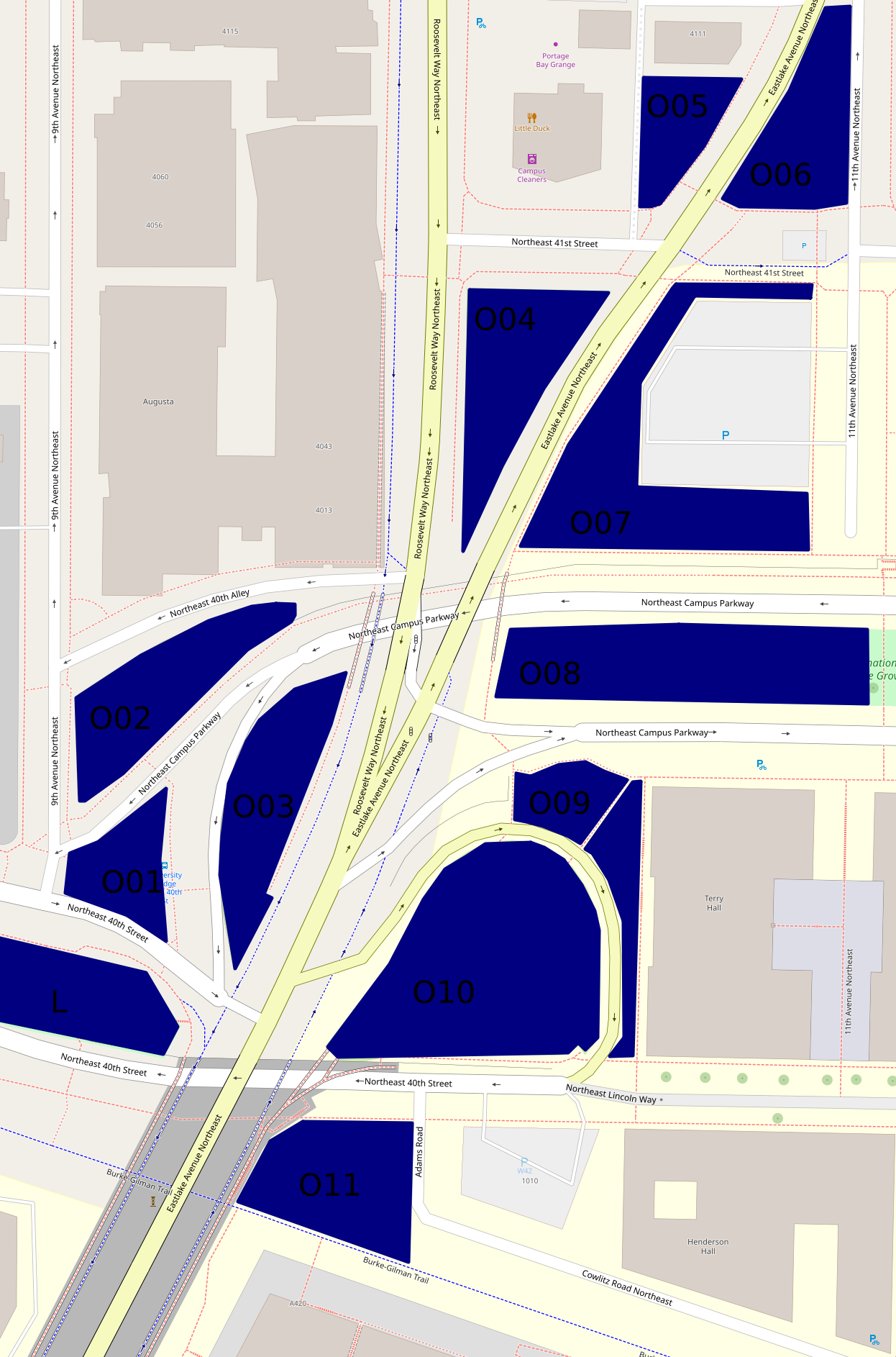
Besides Peace Park (L on the map, and covered in the previous part), there are eleven other green areas that form an only mildly discontinuous belt around and north of the place where the University Bridge joins North Seattle's street grid.

Here's a map, which differs somewhat from the map up above as well as being on a much larger scale:


The hill off the bridge (O10 on second map)

This entirely grassy hill more or less between 40th St and Eastlake Ave has at its southern side a ramp off the bridge.  Of these areas, this was the first I visited on December 22nd, 2020.  But I'm choosing a photo taken October 29th:


The King County Parcel Viewer says that the northeastern part of this area, mid-right on that photo taken looking west, belongs to the university, the rest to the city (and probably specifically SDOT).  I have no idea why there's a crop circle in this land which isn't farmed.

The woods below the bridge (O11 on second map)

If I understand the parcel viewer correctly, this area is half university (east), half city (west).  It has a path between a very short Adams Road which I thought, when mapping northern West Campus, was a spur of Cowlitz Road, and the Burke-Gilman Trail.  This photo is from December 2020.


This woods appears to have been much used by homeless people.  Partly because of this, and partly because it's the least traffic-affected, most park-like, of these areas, I've taken more photos of it than of any of the rest, five versus one or two.  I'm surprised SDOT hasn't fenced it off too.  This photo is from October 29th.


The bus stop triangle (O01 on second map)

Behind the bus stop north of Peace Park is this small, path-broken woods.  It's between 40th St, 9th Ave, and two arms of Campus Parkway, and it's city-owned.  This photo, and all those until the last of these areas, are from October 16th.


Another wooded place (O02 on second map)

This one is between 40th Alley (according to OpenStreetMap), Campus Parkway, and 9th Ave, and is city-owned.


And another... (O03 on second map)

This one is between Campus Parkway and Roosevelt Way, and is also city-owned.


A grassy place (O04 on second map)

This is a triangle between Eastlake Ave, Roosevelt Way and 41st St.  It's university-owned.


And another... (O06 on second map)

This is a triangle, or really a series of triangles, between Eastlake Ave, 11th Ave, and the line of 41st St.  It appears to be city-owned.


A landscaped place (O05 on second map)

The land south of 4111 11th Ave NE, between Eastlake Ave and an alley, turns out not to belong to that building's owners, but to the university, at least according to the parcel viewer.  It's landscaped pretty fully, with trees, large stones at its borders, and slopes, a rather lovelier deterrent to campers than most I've seen.


And another... (O07 on second map)

This is the landscaping around a parking lot, between Eastlake Ave, 41st St, 11th Ave, and Campus Parkway.  It's university-owned.  From its southwest corner, the parking lot isn't even visible.


A block of Olympic Vista (O08 on second map)

Olympic Vista is the park that consists of the boulevard islands in the street Campus Parkway.  All clear?  I'd assumed Olympic Vista was university property; at least two aspects of its landscaping suggest the university's intervention; but according to the parcel viewer, it's all city land.  Anyway, what with all the grassy areas east of Eastlake, the woods at this end of Olympic Vista rather stand out.  However, I'll cover them with the rest of the park, in the next part, tomorrow.

Borderlands (O09 on second map)

Most of the land between Campus Parkway, Eastlake Ave, the road between those, and the university's Terry Hall is more or less green.  In the second map, it's split by a path.  That path is really there, and this area is grassy on the north side, landscaped on the east side.  Photos taken October 29th.


The University of Washington Farm at Mercer Court (P on first map)

That's the best name I can come up with for a park that's actually a bit bigger than the farm's fields.  Essentially all the land between the buildings of Mercer Court, a set of student apartment buildings, except building A to the north, is park.  Each space - between buildings B and C, C and D, and D and E - has the same series of elements:  fields from Pacific St to the stairs, a landing with more fields, more fields on top, then bushes, then benches.  From those benches, if not for the bushes, Portage Bay could probably be seen.  What differs is mainly the relative size of these elements.

Oh, the UW Farm?  It's real, it grows a few tons of food each year, and it supplies that food mostly to other places on campus but to some extent to outsiders as well.  (It offers various CSA plans, some of which appear to be sold to the public but not others; it supplies food to many campus venues and two I can't identify; it gives food to the UW Pantry, the University District Food Bank, and Fare Start.)  This is one of its main locations; we'll meet the other in East Campus someday, and a small new one in (north) Central Campus probably sooner, dear Diary.

I don't see a way for someone who can't handle stairs to get to the fields on the landings at all.  Also, I'm pretty sure getting to the stairs involves gravel paths in all three spaces.  (EDIT November 15:  Wrong.  In the western third, between buildings D and E, one can walk the whole way on pavement.)  So this park is relatively inaccessible to mobility-impaired people, such as me when in December 2020 I was pushing a cart; I took two not very interesting photos and went on.  So my single biggest concern on October 29, when I went back to the parks of that December 2020 hike, was this park.  I took photos on October 29 of each of the three bench areas, each of the three landings, and each of the three Pacific St views.  Fortunately, my preferred photos illustrate all three categories and all three spaces.


The benches photo is from between buildings D and E, the landing photo between buildings C and D, and the Pacific St photo between buildings B and C.

Well, that's all I have for you today, dear Diary.  Tomorrow I hope to tell you about Olympic Vista and the itty bitty parks near it, and then on Tuesday the buildings of southern West Campus.  But we'll just have to see.  Have a good night and good hours of days and nights until we meet again.


Friday, November 4, 2022

Six Hikes in Brooklyn, part II: West

Dear Diary,

Hello again!  This part of this page concerns four park-like areas, none of which is actually officially a park, and one and a half of which are fenced off.  Weirdly, although this area is southwest of the area covered by the previous part and north of the area covered by the next part, both of which include UW buildings, the area I'm discussing in this part has none.

To avoid stuffing Blogspot too full of photos in any one part, I didn't make the area this part covers neat and boxlike the way the previous part's area is.  But here's a map:


University District P-Patch (D on map)

Well, at least this part includes one official place, even if it isn't really a park.  As usual, I don't have much to say about it.


I took that photo October 8, on the hike about city properties listed in the 2020 real property report.

The other NE 40th St island (E on map)

NE 40th St has an island from Latona Ave NE to 7th Ave NE, and another from 7th Ave NE to Eastlake Ave NE, that is, the University Bridge head.  The latter island is pretty much Peace Park, a Seattle Department of Transportation park on which the Seattle Department of Parks and Recreation has conferred the honour of its own Web page.

But the island I mentioned first?  I'm pretty sure it's also SDOT land.  But it isn't as steep as the Peace Park island, which I guess makes it unsuitable for the stairs that island has, so instead SDOT has just fenced it off.


It's that way on the other side of I-5 as well, except the first block, from Latona to 4th Ave NE, where it's open.  I took this photo on October 16, a hike about places that looked interesting on Open Street Map.  I wish enough other people were interested in this island to get SDOT to do something with it.

This is the area I added to this part.  Without it, this part would cover the area from I-5 to 9th Ave NE, and from NE 42nd to NE 40th Streets.

Land east of I-5, area 10 (F on map)

A week and a half ago, in a previous page about the parks of the same region, I broke my rule against identifying places where homeless people live with regard to land east of I-5, because I thought some had been swept from this area here and the next area I'm going to talk about.

But because I don't take photos of camps, I'm not sure.

The area I'm describing here is along NE 40th St between 7th and 5th Avenues NE, but it's actually between Pasadena Place NE and a gravel trail that goes from NE 42nd St's intersection with 5th Ave NE (slightly east of where 5th meets 40th) to 40th.  To the east of this gravel trail, the land under I-5 is fenced off.  Eventually one passes a working area, also fenced off, which presumably belongs to the land's owner, the State of Washington Department of Transportation.  Beyond that is an unfenced hill, down to 40th.

Strictly speaking, only some of this area is in any sense east of I-5, and so part of this page's remit.  But anyway, what's weird about this structure is that I remember tents on the hill, in the western part of the unfenced area, specifically because they constrained my photography, on the 16th when I first came here.  They were gone by the 23rd, if my memory is right; but it may not be.

Thing is, there's still a much bigger encampment uphill, behind the fence, as if sheltering from Seattle's sweeps in WSDOT's arms.  Also, the hill area I thought had been swept is clean, but the other area I thought swept is far from clean, as if two sweeping teams with completely different instructions had done the job.  It's really much simpler to assume my memory is making the whole thing up.

(In the next part of this page, we'll get to a real sweep that happened on the 25th, exactly while I was out looking for evidence of this probably imaginary sweep.)

Anyway, I think the hill would be a great place for kids to toboggan or sled, if we do get snow in the next week, but it might be a little risky, because for some reason it's all posted against trespassing:


Here's the best of the photos I took otherwise:


Both of these photos were taken on October 23rd.

Land east of I-5, area 11 (G on map)

This is a stretch of vacant land, at least some of which the King County Parcel Viewer says is WSDOT-owned, across Pasadena Place from I-5.  To walk past it is to see overgrown shrubbery interrupted several times by clearings.  On the 16th all these clearings were inhabited.  On the 23rd, only one, better hidden, and by the 25th the men living there told me they planned to leave soon.

Yesterday I walked along I-5 and saw that the camps I'd already mentioned are still there.  I hope the people in them find better futures, but until they do, I'd rather they not be handed worse ones with sweeps, so will stop breaking my rule from here.

As I implied above, these clearings were quite messy on the 23rd, when I took my photos.  Here are two photos of the northernmost clearing, showing mess:


and overgrown grass:


Next part, Southwest, probably tomorrow.  It includes Peace Park and several other parks recognised by, but not owned by, the Seattle parks department.  Until then, good night, dear Diary, and good day.


Friday, October 21, 2022

Low Technology

Dear Diary,

One of the things I've been doing to prepare both for hiking in the rain and for the possibility I'll become homeless again is buying ball point pens.

I bought several gel pens with the stimulus money.  I can see why stores prefer to sell them:  they're much more expensive than ball point pens, and they don't last as long.  But the particular thing that matters to me is this:

Turns out, according to Wikipedia, gel pens use water-soluble inks, so this would've been predictable if I'd bothered with the topic.  In contrast, ball point pens use oil-soluble inks, so when today I was trapped by thorny vines on undeveloped 38th Ave NE, and had to set my bags down to deal with the situation, my notes got wrinkled on their bottom edges, but didn't dissolve beyond recall:

I got these pens by doing a study.  This particular study advertised how much it paid heavily, but hid the fact that it paid only in Amazon dollars, not real dollars, in the fine print.  So I had 75 Amazon dollars, no help at all in paying rent, but when I was unable to buy even red ball point pens at local stores, let alone green or purple ones, I remembered them, and spent half of the 75 getting those three colours (including shipping).

I don't actually think of myself nearly as often any more as old-fashioned, as I used to.  These days I generally pick whatever looks more sensible to me.  I can't afford to subscribe to the newspaper until I get a lasting job, and it's looking like, because I've had so many jobs that didn't last in the past, I'll probably never get another one that does last.  (This is also why I still pay shipping fees to Amazon.)  That said, I use a print newspaper in taking door shots of restrooms, water fountains and similar things because it's a convenient way of setting a visible terminus post quem, not because I have some objection to digital news.

But it's still true that I don't object to older technology, such as ball point pens and print newspapers, just because it's older.

Anyway, dear Diary, I look forward to telling you what those notes mean, and the others too, but I'm really, really tired, and tonight I'm going to relax, listen to music, and read instead.  I hope to return by Sunday, maybe even sooner, but for now, have a happy weekend, and wish one to anyone who reads you too.


Tuesday, October 18, 2022

Three Hikes in Ravenna, part III: Southeast

Dear Diary,

Hello again.  This time we're back to just three hikes - Saturday, October 8; Wednesday, October 12; and Sunday, October 16.

Map:


On October 12, I went to properties listed in the City of Seattle's real property report for 2020.  (I prefer that because a bunch of properties of interest to me have been left out of later reports; it seems to have to do with the extent to which the city owns rather than leases the property.  The 2022 report has new problems, such that it's pretty nearly useless to me.  Sometime when it's raining too hard to go hiking, I should look at the now ten reports available online and do a detailed comparison.)

Ravenna P-Patch (A on map)

This P-patch is actually adjacent to a stairway, equivalent to 52nd St, which I've mentioned to you before, dear Diary, and even shown you a photo or two of, if I remember correctly.  Here's a photo meant to be of the P-patch, but I seem to have gotten rather too much of the stairway into it; if I can rely on my memory, this will have been because at least one person was gardening in the P-patch at the time.  Anyway, the photo:


Ravenna Woods (B on map)

This is an actual Seattle Department of Parks and Recreation park, but I don't think I've had much to tell you about it, dear Diary, because I experience it mostly as a dead end.  However, it turns out the park ends way north of where I thought it did, and most of my travel there has been on private property.  Anyway, I found an actual way to escape it this time, an obviously unofficial stairway adjacent to a building.  But I didn't want to risk that sleep and unsteady path a second time, when I finally thought of something to photograph.  Of course, here's an ordinary landscape, showing how much of this park is really its gravel trail:


But the first time I told you about this park, dear Diary, I mentioned some kids I thought homeless, who'd been cooking in front of a shed.  I'm pretty sure I found the shed, and I'm pretty sure, looking back, that it's actually on private property, which puts those kids' activity into a much more questionable light.  But anyway, here's a photo that includes part of the shed.


The Burke-Gilman Trail (C on map)

Something big has changed, at the Burke-Gilman Trail and NE 47th St.  A new apartment building decided to supply a new exit from the trail, a much more impressive thing than most exits:

There's also new signage:


including a feature I'll have a lot more to say about when I get back to downtown.  And finally, there's a new water fountain there.  I don't know if the money came from the building's developer or owner, but the fountain appears to me to be on park property, and is a design Seattle's parks department uses a lot:


Anyway, that's it for this page of my hike on October 8.

On October 12, I was mainly doing other things, but did photograph the whole of this next park.

17th Ave NE Center Strip

After the two boring photos I showed you in the previous part of this page, it dawned on me that I'd better change how I photographed the rest of the boulevard (which is what this is, just a fairly boring boulevard).  So here goes.  On the block from 55th to 52nd streets, I first tried an angle shot:


Then I found what I think is the first furniture put on this boulevard so far this academic year.  In "Ravenna Boulevard", I'd mentioned that as the clearest way of distinguishing between the blocks of this boulevard.


What I meant was furniture at least potentially useful to people visiting the boulevard islands, but since mentioning it in that page, I've walked 17th Ave many more times, and found other kinds of furniture also abandoned there.

Next, I figured since this tree on the island from 52nd to 50th was the best thing about that block, I should photograph it:


Over the last two blocks, the boulevard deteriorates, no doubt because it's more walked on, so I went back to conventional shots.  50th to 47th:


And 47th to 45th:


University Presbyterian Church (D on map)

On the 16th I visited things I'd noticed on Open Street Map while making earlier drafts of the maps I've been showing you, dear Diary.  This church is where I was sent by, I think, a staffer at another church, during one of the UW's snow closures.  At least at that time, it was allowing people to stay inside only a limited time, I think a quarter or half hour, I think so people sheltering there wouldn't too badly outnumber the staff.  On the 16th, I'd arrived much too late for their regular posted hours:


So I settled for trying for a postcard shot of the building:

Thanks, guys!

Another stairway park (E on map)

Fraternity Row infrastructure isn't exactly my idea of Ravenna, but actually, this parklet is just a block from Ravenna Woods.  Around the stairway, it's really overgrown:


But further south it flattens out, and there it's grassy:


All for tonight, dear Diary.  My landlord has started showing the room next door to me, so I probably can't keep writing so late much longer.  Tomorrow, I hope to write "Four Hikes in University Heights", and the page about the UW and visitors to its buildings.  A good night and day until then, dear Diary.