Showing posts with label other homeless. Show all posts

Saturday, November 12, 2022

Six Hikes in Brooklyn, part IV: Centre

Dear Diary,

This part concerns three places which I visited December 22nd, 2020; October 8th, this year; October 16th; and October 29th.  Two of the places are large and complex, divided into lots of parts, so this is a pretty photo-heavy part of this page.

Map:


The Burke-Gilman Trail and the Land under University Bridge (N on map)

Most of the Burke-Gilman Trail in this entire region - that is, from the water to NE 65th St and from I-5 to 25th Ave NE - is on land owned by the University of Washington.  However, the City of Seattle Department of Transportation owns the land under the University Bridge, including that chunk of the trail.

Before the pandemic, the part of the trail under the bridge was a favoured hangout for local teens.  Up the slope, locally north, there were and are concrete blocks attached to the concrete pavement; opposite that area is a flat place, with a sign saying "The Wall of Death", presumably referring to the difficulty of skateboarding the slope opposite.  On the rare occasions that I walked along that part of the trail, I sometimes stopped and put my satchels down on the dry parts of the flat area, but sometimes couldn't, because there were so many teens around.

During the early phase of the pandemic, a homeless encampment formed in that flat place.

By December 2020, that encampment had already been swept:


And a fence put up.  That fence is still there:


Dear Diary, I've recently been reading Skid Road:  On the Frontier of Health and Homelessness in an American City by Josephine Ensign, Baltimore:  Johns Hopkins University Press, c2021.  This is not actually a history of homelessness in Seattle, as a review had led me to believe; Ensign, herself a nursing professor, is too interested in the history of health care for the homeless, as her subtitle already makes clear, to give anything like a full account of the broader history.  But she does make it clear that Seattle has always had homeless people.  So those who have claimed in recent years to be trying to end homelessness here are struggling against history.

But I've had a great idea.  A way to really end homelessness in Seattle.  All we have to do is fence off all the public property.  Not just this flat place where some homeless people recently had the audacity to camp, but the whole trail.  All the sidewalks.  All the streets.  Every bit of it.  I'm quite sure that by the time the job was done, there would be no homeless people left in Seattle.

Of course, nobody else would be alive here either.  I think the decisive moment would come when the city's water supply shut down because the people trapped in the relevant places starved.  After that, the end would come in a few days.

But isn't that a small price to pay, to solve a problem that's already lasted nearly two centuries?

Unfortunately, SDOT hasn't yet tried to go that far.  The Wall of Death itself, as opposed to its sign, remains open:


though I would imagine some skateboarding moves could be difficult with that fence in the way up top.

One thing that has changed is that a graffito I saw in December 2020 is now gone:


Areas around University Bridge (O on map)

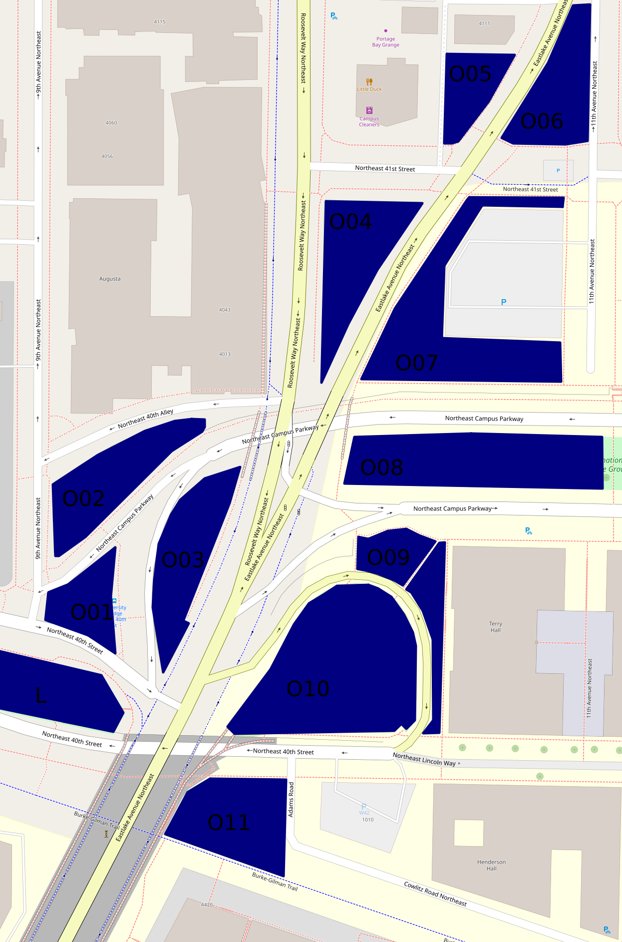
Besides Peace Park (L on the map, and covered in the previous part), there are eleven other green areas that form an only mildly discontinuous belt around and north of the place where the University Bridge joins North Seattle's street grid.

Here's a map, which differs somewhat from the map up above as well as being on a much larger scale:

The hill off the bridge (O10 on second map)

This entirely grassy hill more or less between 40th St and Eastlake Ave has at its southern side a ramp off the bridge.  Of these areas, this was the first I visited on December 22nd, 2020.  But I'm choosing a photo taken October 29th:


The King County Parcel Viewer says that the northeastern part of this area, mid-right on that photo taken looking west, belongs to the university, the rest to the city (and probably specifically SDOT).  I have no idea why there's a crop circle in this land which isn't farmed.

The woods below the bridge (O11 on second map)

If I understand the parcel viewer correctly, this area is half university (east), half city (west).  It has a path between a very short Adams Road which I thought, when mapping northern West Campus, was a spur of Cowlitz Road, and the Burke-Gilman Trail.  This photo is from December 2020.


This woods appears to have been much used by homeless people.  Partly because of this, and partly because it's the least traffic-affected, most park-like, of these areas, I've taken more photos of it than of any of the rest, five versus one or two.  I'm surprised SDOT hasn't fenced it off too.  This photo is from October 29th.


The bus stop triangle (O01 on second map)

Behind the bus stop north of Peace Park is this small, path-broken woods.  It's between 40th St, 9th Ave, and two arms of Campus Parkway, and it's city-owned.  This photo, and all those until the last of these areas, are from October 16th.


Another wooded place (O02 on second map)

This one is between 40th Alley (according to OpenStreetMap), Campus Parkway, and 9th Ave, and is city-owned.


And another... (O03 on second map)

This one is between Campus Parkway and Roosevelt Way, and is also city-owned.


A grassy place (O04 on second map)

This is a triangle between Eastlake Ave, Roosevelt Way and 41st St.  It's university-owned.


And another... (O06 on second map)

This is a triangle, or really a series of triangles, between Eastlake Ave, 11th Ave, and the line of 41st St.  It appears to be city-owned.


A landscaped place (O05 on second map)

The land south of 4111 11th Ave NE, between Eastlake Ave and an alley, turns out not to belong to that building's owners, but to the university, at least according to the parcel viewer.  It's landscaped pretty fully, with trees, large stones at its borders, and slopes, a rather lovelier deterrent to campers than most I've seen.


And another... (O07 on second map)

This is the landscaping around a parking lot, between Eastlake Ave, 41st St, 11th Ave, and Campus Parkway.  It's university-owned.  From its southwest corner, the parking lot isn't even visible.


A block of Olympic Vista (O08 on second map)

Olympic Vista is the park that consists of the boulevard islands in the street Campus Parkway.  All clear?  I'd assumed Olympic Vista was university property; at least two aspects of its landscaping suggest the university's intervention; but according to the parcel viewer, it's all city land.  Anyway, what with all the grassy areas east of Eastlake, the woods at this end of Olympic Vista rather stand out.  However, I'll cover them with the rest of the park, in the next part, tomorrow.

Borderlands (O09 on second map)

Most of the land between Campus Parkway, Eastlake Ave, the road between those, and the university's Terry Hall is more or less green.  In the second map, it's split by a path.  That path is really there, and this area is grassy on the north side, landscaped on the east side.  Photos taken October 29th.


The University of Washington Farm at Mercer Court (P on first map)

That's the best name I can come up with for a park that's actually a bit bigger than the farm's fields.  Essentially all the land between the buildings of Mercer Court, a set of student apartment buildings, except building A to the north, is park.  Each space - between buildings B and C, C and D, and D and E - has the same series of elements:  fields from Pacific St to the stairs, a landing with more fields, more fields on top, then bushes, then benches.  From those benches, if not for the bushes, Portage Bay could probably be seen.  What differs is mainly the relative size of these elements.

Oh, the UW Farm?  It's real, it grows a few tons of food each year, and it supplies that food mostly to other places on campus but to some extent to outsiders as well.  (It offers various CSA plans, some of which appear to be sold to the public but not others; it supplies food to many campus venues and two I can't identify; it gives food to the UW Pantry, the University District Food Bank, and Fare Start.)  This is one of its main locations; we'll meet the other in East Campus someday, and a small new one in (north) Central Campus probably sooner, dear Diary.

I don't see a way for someone who can't handle stairs to get to the fields on the landings at all.  Also, I'm pretty sure getting to the stairs involves gravel paths in all three spaces.  (EDIT November 15:  Wrong.  In the western third, between buildings D and E, one can walk the whole way on pavement.)  So this park is relatively inaccessible to mobility-impaired people, such as me when in December 2020 I was pushing a cart; I took two not very interesting photos and went on.  So my single biggest concern on October 29, when I went back to the parks of that December 2020 hike, was this park.  I took photos on October 29 of each of the three bench areas, each of the three landings, and each of the three Pacific St views.  Fortunately, my preferred photos illustrate all three categories and all three spaces.


The benches photo is from between buildings D and E, the landing photo between buildings C and D, and the Pacific St photo between buildings B and C.

Well, that's all I have for you today, dear Diary.  Tomorrow I hope to tell you about Olympic Vista and the itty bitty parks near it, and then on Tuesday the buildings of southern West Campus.  But we'll just have to see.  Have a good night and good hours of days and nights until we meet again.


Saturday, November 5, 2022

Six Hikes in Brooklyn, part III: Southwest and Its Sweeps

Dear Diary,

None of the individual parts of this page concern all six hikes its title mentions; but this one concerns four of them, the next part too; all the others discuss only three.  Let's look at the whole set here:

  • On December 22nd, 2020, I went hiking throughout southern Brooklyn, city and university parks both.  I ended up using some of the photos of the city ones in "Canalwards, Foolish Mortal" on January 1st, 2021, and deleted those from my phone as usual, so all I have left from this date are photos of places I associated with the university.  This hike hasn't featured in the previous parts but is in all the remaining ones.
  • On October 8th, 2022 I started hiking this area focusing on properties listed in the City of Seattle's 2020 Real Property Report.  This hike is in all the parts except part V, assuming I get that far.
  • On October 16th I went back, focusing on areas that looked park-like in Open Street Map.  This hike is in all the parts except this one and part VI.
  • On October 23rd I re-visited I-5 lands; photos from this hike were in parts I and II.  I-5 this far south is well above street level, so there aren't any photos from this hike in this part.  And the remaining parts of this page are east of I-5, so they won't have any either.
  • On October 25th I photographed two sweep notices in the area this part covers.  So none of the other parts have photos from this date.
  • And on October 29th I re-photographed the areas of which I still had December 22nd, 2020 photos, because I thought I needed to re-visit them all before telling you, dear Diary, about them anyway.  This part and all those remaining have photos from this hike.

This part not only features the most hikes, it also features the most places; even after I took the forgotten island in NE 40th St out of this part, it still has six left to talk about, as does part V; the others, three or four.

As in previous parts and previous pages from my October hikes to Ravenna and the U-District, in each individual part or page I'm going in order of the hikes.

So we start with:

805 NE Northlake Place (H on map)

Oh, oops, I've written myself out of having space for the map in the introduction, haven't I?  But let's continue that for a moment while I show you, dear Diary, the first of the December 2020 photos of places I thought belonged to the university.  In this case, the university's map agrees with the King County Parcel Viewer that I thought correctly.


My unreliable memory claims that I was struck, as I trudged from the Burke-Gilman Trail and North Passage Point back towards campus that day, by this explosion of green (in December, mind!) in a rather grittily urban neighbourhood.

Oh, neighbourhood, map, right?  Here:


That's the only place in this area of which I still have a December 22nd, 2020 photo, dear Diary.

So going on with October 8th:

North Passage Point (I on map)

This park was actually the reason I picked this region to start with.  I'd gone through the Seattle Department of Parks and Recreation list of parks and found no additions in North Seattle, but one subtraction:  this park.

Most of it is the property of the State of Washington Department of Transportation, which has apparently stopped leasing it to the parks department and fenced it off because of chips of concrete falling from the I-5 bridge.  A host of sites still document it, but not the parks department's, so apparently the department's taken down its web page.

But such measures don't actually lead to actual land disappearing from the face of the Earth, so I went there to see what I could see.

What I saw was a fenced-off park.  I saw a man inside the fence to dip his toes in the water, who clambered over a shorter fence adjacent to leave; I saw a woman inside the fence to walk her dog, but she left on the other side, so I don't know how she left.


The shorter fence is in the photo immediately above.  But you see, dear Diary, there's also a gate, and if that woman had a key, she might've used that:


The side I was on while taking the first three photos is the parks department's side, which is not fenced off.  It includes the sidewalk whose decorations I praised on first visiting this park early in your life so far, dear Diary, and it includes some grassy land, on which, on this visit, I found an encampment of tents, presumably including homeless people.  Neither of the people I saw inside the fence lived there.

Northlake Park (J on map)

This "park" is simply an overlook adjacent to the sidewalk.  Well, the 2020 real property report claims it occupies 1,660 square feet, which implies that the land below the sidewalk, seaward, is the real park, but that's fenced off.  So most of my photos of this park have been views, and so's this one:

For much more about this park, see "Canalwards, Foolish Mortal", linked up top.

Eastlake Ave NE Street End (K on map)

For much more about this park (not belonging to the parks department, and frankly not much of a park), see the street end page that includes it.


Peace Park (L on map)

My main concern in re-visiting all the parks in this region was to see what had changed.  Specifically whether water fountains had been added, for example, but also to see what had been subtracted from North Passage Point.  Or here.


That statue is "Sadako and the Thousand Cranes", made in 1990 by Daryl Smith, who is not the glass artist born circa 1973 and is not the artist in wood who was a school principal in Indiana at the time (LinkedIn link, requires sign-in), but is surprisingly poorly documented considering he also made the Jimi Hendrix and other rock legend statues on Capitol Hill.  And what has changed is that Sadako (portraying Sasaki Sadako, 1943-1955) doesn't have anything, not cranes, not candies, not nuthin'.

Cheshiahud Lake Union Loop (M and brick-red line on map)

I still haven't done enough research to reconcile the widely varying online accounts of Cheshiahud, an Indian with whom the 19th century settlers of Seattle interacted.  But at least I've finally paid enough attention to the flimsy little markers with which this sort of virtual trail, made out of existing roads, trails, and whatnot, is pointed out, to establish its path in the U-District.  Which led me to the shocking discovery that the parks department page links to a perfectly good map (1-page PDF) that could've saved me the trouble.  I think when I first downloaded that map on my phone, I couldn't get the phone's software to fix its mis-orientation, so forgot about it.  But I think one of the photos I took documenting my not so trail-blazing effort is worth showing you anyway, dear Diary:


So enough park appreciation.  We now take some time out for sweeps.

805 NE Northlake Place

On the 23rd, visiting various I-5 patches of land, I'd come to the conclusion that the land from 40th to 42nd had been swept.  This surprised me, because I knew that WSDOT had been criticised by homeless-haters as far too slow to sweep encampments for their tastes. [1]  So on the 25th, I went back to see whether my conclusion was right, and concluded, as related to you, dear Diary, in part II, that it probably wasn't.

[1] For more on WSDOT and sweeps, see an article by Leo Brine in Publicola on a bill that ultimately failed.

I don't have a clear record of what I did after that on the 25th, but anyway, I eventually came back here.  And found that a bunch of RVs that had been parked just north of here, essentially blocking drivers from reaching the end of Northlake Place, had been swept that very day, probably while I'd been dithering over I-5 land.  The only notice I found was this one:


Now, this came as a complete surprise to me.  Not the sweep, that is, but the notice.  I'd seen a sweep notice just two weeks before, issued in mid-September.


The two most obvious differences are that the new ones are much easier to read, and don't have dates issued.  The more I thought about it, the more confident I became that they weren't sweep notices at all, but notices following a sweep, intended to help people reclaim their property (or at least, ostensibly so intended).  So I freaked out all over again.  Had Seattle finally decided to stop warning people of imminent sweeps?

North Passage Point

It's certainly gotten looser in its legalese:


Unless I'm living on a different planet from the writer of that notice, North Passage Point isn't in "Burke Gilman Trail to NE Northlake Way and from Eastlake Pl NE to Pasadena Pl NE", it's south of NE Northlake Way.

So I went home and wrote to two real journalists who might be interested, neither of whom has replied so far.  And I stewed.  But six days later, when I came back to re-photograph the university parks of West Campus...

805 NE Northlake Place

I found two RVs parked along Northlake Place again, and the owner of one, who called himself Red, hailed me.  He told me he'd been on the streets most of the time since he was ten years old, and he was 42 at the time.  He said they had in fact gotten notice - visitors.  He also said his RV didn't run, needed a new engine which he couldn't afford.  Which I interpreted as meaning that his RV had been towed (either by the sweepers, or by a friend beforehand), and then returned to him.

So I still don't know whether Seattle is continuing to post sweep notices, physical objects that nosy people like me can see, as opposed to just notifying people they find on-site.  But it isn't (at least in this case) doing something as obviously wicked as not warning people at all that their lives will be up-ended.

Which brings me to the last photos in this photo-heavy part, since I then took a closer look at the explosion of greenery.  It turns out not to be so very green.  In fact, there's a big clearing in the middle of this vacant block.


Although I wanted to spend today at home, I panicked when I saw that both Open Street Map and Google Maps show a building on this block.  Had I gotten something catastrophically wrong?

The Department of Neighborhoods has a photo of a building, dated 2002.

The Department of Finance and Administrative Services has an April 2015 notice that the property is for sale (6-page PDF).  The city had acquired it in 1971 thinking it would need it for work being done at the time on Pacific St (which Northlake Way turns into there).  At the time a sculptor they call Theodore Jonsson already leased the land, and the city had renewed the lease as recently as 2014 (10-page PDF), but that was due to expire in 2019.  They worried that his sculptural work, in metal, had led to environmental contamination.

As it turned out, Jonsson, who'd been born in 1933, died in June 2015 at his daughter's house.

So the damage to the land, and a few bits and pieces, are what's left of the building.  This is a surprisingly recent park; its life as such can't have begun before 2015, which means the nearly two years between December 2020 and today are a significant part of its lifespan so far.  That it's come this far without, possibly, any real work by anyone, is impressive.

Meanwhile, I got the impression that Jonsson was another poorly documented sculptor, but that's because I'd looked for him as Theodore.  Turns out there are several pages memorialising "Ted Jonsson" and depicting his art.  He was an important advocate for the 1% for art policy, and an early beneficiary too.  His art isn't much to my taste, but I've liked plenty of other work paid for with 1%, so on balance, I'm grateful.  And also for whatever hypothetical pollution he may have produced that's intimidated anyone from building on his studio's former site.

So, dear Diary, another part with an ambiguously happy ending.  Good night, and happy hours until we meet again tomorrow.


Friday, November 4, 2022

Six Hikes in Brooklyn, part II: West

Dear Diary,

Hello again!  This part of this page concerns four park-like areas, none of which is actually officially a park, and one and a half of which are fenced off.  Weirdly, although this area is southwest of the area covered by the previous part and north of the area covered by the next part, both of which include UW buildings, the area I'm discussing in this part has none.

To avoid stuffing Blogspot too full of photos in any one part, I didn't make the area this part covers neat and boxlike the way the previous part's area is.  But here's a map:


University District P-Patch (D on map)

Well, at least this part includes one official place, even if it isn't really a park.  As usual, I don't have much to say about it.


I took that photo October 8, on the hike about city properties listed in the 2020 real property report.

The other NE 40th St island (E on map)

NE 40th St has an island from Latona Ave NE to 7th Ave NE, and another from 7th Ave NE to Eastlake Ave NE, that is, the University Bridge head.  The latter island is pretty much Peace Park, a Seattle Department of Transportation park on which the Seattle Department of Parks and Recreation has conferred the honour of its own Web page.

But the island I mentioned first?  I'm pretty sure it's also SDOT land.  But it isn't as steep as the Peace Park island, which I guess makes it unsuitable for the stairs that island has, so instead SDOT has just fenced it off.


It's that way on the other side of I-5 as well, except the first block, from Latona to 4th Ave NE, where it's open.  I took this photo on October 16, a hike about places that looked interesting on Open Street Map.  I wish enough other people were interested in this island to get SDOT to do something with it.

This is the area I added to this part.  Without it, this part would cover the area from I-5 to 9th Ave NE, and from NE 42nd to NE 40th Streets.

Land east of I-5, area 10 (F on map)

A week and a half ago, in a previous page about the parks of the same region, I broke my rule against identifying places where homeless people live with regard to land east of I-5, because I thought some had been swept from this area here and the next area I'm going to talk about.

But because I don't take photos of camps, I'm not sure.

The area I'm describing here is along NE 40th St between 7th and 5th Avenues NE, but it's actually between Pasadena Place NE and a gravel trail that goes from NE 42nd St's intersection with 5th Ave NE (slightly east of where 5th meets 40th) to 40th.  To the east of this gravel trail, the land under I-5 is fenced off.  Eventually one passes a working area, also fenced off, which presumably belongs to the land's owner, the State of Washington Department of Transportation.  Beyond that is an unfenced hill, down to 40th.

Strictly speaking, only some of this area is in any sense east of I-5, and so part of this page's remit.  But anyway, what's weird about this structure is that I remember tents on the hill, in the western part of the unfenced area, specifically because they constrained my photography, on the 16th when I first came here.  They were gone by the 23rd, if my memory is right; but it may not be.

Thing is, there's still a much bigger encampment uphill, behind the fence, as if sheltering from Seattle's sweeps in WSDOT's arms.  Also, the hill area I thought had been swept is clean, but the other area I thought swept is far from clean, as if two sweeping teams with completely different instructions had done the job.  It's really much simpler to assume my memory is making the whole thing up.

(In the next part of this page, we'll get to a real sweep that happened on the 25th, exactly while I was out looking for evidence of this probably imaginary sweep.)

Anyway, I think the hill would be a great place for kids to toboggan or sled, if we do get snow in the next week, but it might be a little risky, because for some reason it's all posted against trespassing:


Here's the best of the photos I took otherwise:


Both of these photos were taken on October 23rd.

Land east of I-5, area 11 (G on map)

This is a stretch of vacant land, at least some of which the King County Parcel Viewer says is WSDOT-owned, across Pasadena Place from I-5.  To walk past it is to see overgrown shrubbery interrupted several times by clearings.  On the 16th all these clearings were inhabited.  On the 23rd, only one, better hidden, and by the 25th the men living there told me they planned to leave soon.

Yesterday I walked along I-5 and saw that the camps I'd already mentioned are still there.  I hope the people in them find better futures, but until they do, I'd rather they not be handed worse ones with sweeps, so will stop breaking my rule from here.

As I implied above, these clearings were quite messy on the 23rd, when I took my photos.  Here are two photos of the northernmost clearing, showing mess:


and overgrown grass:


Next part, Southwest, probably tomorrow.  It includes Peace Park and several other parks recognised by, but not owned by, the Seattle parks department.  Until then, good night, dear Diary, and good day.


Monday, October 24, 2022

Four or More Hikes in University Heights

Dear Diary,

Sorry it's a day later than I predicted.  It turns out I can't keep all the geography of I-5 in the U-District in my head at once; I went out twice yesterday and once today to look at it again.  Anyway.  This page concerns hikes on the 8th, 14th, 16th and 18th of this month, and the dozen places I think fit best here.  That's rather a lot, so let's get started.

We're going to need two maps for these places.  Here's the first, which shows most of them:


On the 8th, as with the other parts of this region of North Seattle, I wanted mainly to visit places owned, leased or otherwise controlled by the City of Seattle, according to the city's 2020 real property report.  (The main reason I don't use later reports is that they only inconsistently include leased property.)  I'd started with Ravenna, and then taken the Burke-Gilman Trail to the area south of University Heights, Brooklyn.  So this was the last area where I took photos that day, though I then unwisely returned to Ravenna chasing an SPU property that turned out to be a mirage.

University Neighborhood Service Center, take 1 (A on map)

I was a quarter hour too late to go inside this rented space, because I'd been looking for ball point pens at the University Bookstore a block south.

On the way to my next stop, I noticed an informational pillar.  It's good to know the U District Partnership is on the ball, keeping up with things timelier than I do:

University Heights Plaza (B on map)

Dear Diary, two and a half years into this, I think I've got the hang of this.  University Heights Plaza, a park owned by Seattle's Department of Parks and Recreation, is a rectangle that's mostly a basketball court, right?


The King County parcel viewer seems to agree.  As I've previously mentioned to you, dear Diary, the "sanican"s and hand-washing station that had been in the plaza during the lockdowns are now gone, so this park is even less a part of my usual rounds than it had been then.  The street sink the cited page mentions isn't on the plaza, but on University Heights's private land, a little north of the P-patch.  Speaking of which...

University Heights P-Patch (C on map)

I think I'm obviously the wrong person to see what, if anything, is distinctive about particular P-patches.  This one at least doesn't have any stairs.


Fire Station 17 (D on map)

When I visited Fire Station 9 in Fremont last summer, I photographed a bunch of signage showing COVID-related closures of various kinds.  Not so here this time:


So my doubts about continuing to point the fire stations out are returning.  I'll have to think about that and let you know, dear Diary.

University branch Library (E on map)

From the downtown hikes of September, I've concluded that it's silly to keep taking restroom and water fountain photos inside buildings, since defects in these things are rarely tolerated for long, unlike in parks.  Also, people inside buildings seem much readier to take offense than people in parks at the use of a camera near restrooms.  However, the only photo I took here, this time, that wasn't a restroom or water fountain shot was a similarly boring door-signage one:

University Playground

The restrooms here have been closed since before the pandemic.  There's still a "sanican", without hand-washing station, in the park, but it's no longer at the back of the restroom building, instead near the northwest exit from the park.  The water fountain works fine.  Relevant photos from October 8th and several past visits are in the Google Drive folder.

I took a landscape shot, unsure whether I'd be back before the next encampment makes such a photo more difficult to take, given my rules:


It occurs to me, dear Diary, that I mostly don't have a clue who reads you any more, so should explain my rules for photo taking again, since they'll be relevant pretty soon.  I don't deliberately photograph people, originally because I didn't want to negotiate image rights while socially distanced, now mainly because I don't really want to negotiate them at all.  I take pains not to photograph homeless people's tents.  I bend these rules where necessary (e.g., photographing anything near Pike Place Market) as long as the people or tents are significantly distant, and even then strongly prefer that the people's faces aren't visible.

Anyway, the remaining stops from October 8 are on the other map, which we've seen before in the first part about hiking Ravenna:


Two snippets (F on second map)

Real property reports mention lots of "parcel"s and "snippet"s.  In previous cases, I've only intermittently been able to identify these.  My record is now a little bit better; I'm pretty sure these protrusions into 8th Ave NE are the two intended by 799 NE 56th St and 810 NE 55th St, 56th first:


I'd rather the report listed the reasonably attractive street circle at 8th Ave NE and NE 56th St:


but although that's pretty certainly city-owned, it isn't what's meant.

Shiga's Garden (G on second map)

Another P-patch:

As implied, that's it for the hike of October 8th in this area.  On October 14, I went to places suggested by Open Street Map, specifically two of them, plus I went back to the Neighborhood Service Center.  But first...

Notes on the land east of I-5 here

In the northwestern part of this region, there's little land east of I-5, as opposed to reasonably generous amounts west of it, enough for a park (NE 60th St Park) and a volunteer garden/orchard (Freeway Estates).  South of 53rd, that all changes, and down to 42nd or so, all the land worth mentioning is east of I-5.  This is partly, but I think not entirely, because of lots of entrances from and exits to the U-District.

The story of this land that I'm prepared to tell today and most likely tomorrow is a story of fences.  For whatever reason, much of the land is fenced in, or fairly recently was fenced in.  Much of the fenced land is steep, which argues that safety is the main concern, but I doubt that's all or even most of it, because much of the fenced land isn't steep, and there doesn't seem to be much correlation between steepness and fencing.  At least one substantial park housed people could plausibly enjoy would be possible near I-5 in the first area I'll discuss below.

Another element of the story:  Some of this land is currently inhabited.  In general, dear Diary, I haven't identified homeless people's use of the land since the previous mayor ramped up sweeps again sometime in 2021.  As I predicted in "Away from the Manger", the last part of my Christmas triptych last year, homeless people have metastasised throughout the city, no longer allowed to be anywhere in numbers, but still finding enough nooks and crannies in both public and private land to avoid (at least as far as I've seen) having to risk using residential porches.  However, in this case some of the land (south of the area this page covers) has recently been swept of holdover encampments; this suggests that the use of the rest (mostly also by holdover encampments) is known to the sweepers.  And I can't tell the story of the fences without talking about the ways in which they've been circumvented, which obviously suggests the land's homeless residents as the agents of circumvention (though hardly the only possible ones).

East of I-5, area 4 (H on first map)

The circumvention here, going south toward 47th St from 50th St, is simple.  The fence has a gate in it, not far south of 50th, and that gate has been open every time, in the over two weeks I've been hiking for these pages, I've gotten close enough to check.  (Mind, that's only been three or four times, but still.)  Near as I can tell, nothing was destroyed unless there was a padlock or some such on the gate.


There aren't many tents here, and it's easy to avoid them while hiking south much of the way to 47th in this substantial area.  It's mostly overgrown grass:


with occasional outcrops of thicker vegetation:


I can't see why these however-many acres have been abandoned like this.  Maybe because of the same sluggishness, on the part of the State of Washington Department of Transportation, that has exasperated the city's leaders because WSDOT hasn't gone all-out to sweep homeless people from its properties as the city has.  But if WSDOT is finally doing sweeps now, I have to wonder why it can't also do something positive at least with this space.

University Child Development School's playgrounds (I on first map)

Dear Diary, when I started writing you, I wondered what the U-District had done, that most of its playgrounds were locked.  There are at least three examples on the UW campus, there's the University Heights playground (on the first map above, but no photos), and then there are these.  Obviously private land owners, like U-Heights and UCDS, have the right to lock up their playgrounds, but where are the public ones that could make such locked private playgrounds irrelevant?  University Playground, whose restrooms haven't been open for years.  And in other neighbourhoods.  That's where.  What's wrong with the U-District having more and better?

Anyway, typical signage for the private playgrounds, emphasising private property:


University Neighborhood Service Center, take 2 (A on map)

On the afternoon of the 14th I managed to get inside this place.  I didn't get anywhere near the counter, there were so many people in line.  I noticed that the public use computer that had been on a desk in the front of this rented storefront was gone; some people were at that desk filling out forms.

This is meant to be a general place for residents of Seattle to deal with their government, and its signage still sort of reflects that.  But they've adopted a sideline that now more or less wags the dog.


From the things they were holding and the things they were saying, I'm pretty sure that all the people I saw in line, with maybe one or two exceptions, were there to get passports, which isn't even a city function.

Unable to reach the staff, I couldn't ask whether they offered a public restroom, but I'm pretty sure I remember their not having one when I visited while homeless a few times, and because where I stood while assessing the situation was near the storefront's back door, I could see signs warning the public away.

Since the 14th most of my hiking has been about loose ends and University of Washington buildings.  You already saw a few signs of the latter, dear Diary, in the third Ravenna page; the first map above has more; Brooklyn's map has tons, which is why I've left that area for last.  But for this region and Brooklyn, the main loose end has been that my record-keeping setup wasn't adequate to handle the land near I-5, so the rest of this page concerns those areas.  I went to these next two on the 16th.

East of I-5, area 5 (J on first map)

This area sandwiched between I-5, an entrance, and an exit, north of 45th St, is pretty seriously inaccessible, even though, as best I can tell, it isn't fenced at all.  I doubt it's inhabited.


East of I-5, area 6 (K on map)

As you can see in the above photo, dear Diary, and still more in this next one, this area, the accessible one north of 45th, is quite steep:

This area is thickly inhabited, so I didn't explore it much.  I think it's possible that the fence survives entirely.  That fence appears never to have enclosed the area shown in blue on the first map, but there are tents on both sides of the fence.  A door-sized gap in the fence along 45th St, where there may have been a door-sized gate, now stands empty; this is presumably how people in the western, fenced-in, tents get out.  Unlike University Heights Plaza, this encampment still has "sanican"s, and an SPU sink that I found running on the 16th, although I screwed up photographing that.


I think most of this area is steep enough that there probably isn't anything more worthwhile to be done with it than what's happening now.  I realise that for the haters of the homeless so common in city government that isn't enough reason to leave things as they are, but I hope whoever makes the decisions about this space continues to make sweeping it a low priority, maybe even contingent on treating the people living there as if they were actually people.

East of I-5, area 7 (L on map)

This area north of 50th St is another steep area, but differs from area 6 in that the hilltop is long, wide and relatively smooth, sort of flattish.  There are several places to climb to it; the further north one goes, the easier the climbs are.  Most of the tents are on or near the hilltop.

There are at least two fences.  One, a typical chain link fence, starts from the bridge and runs some distance along 50th, then turns north.  The other fence, which comes from the north, is made not of metal but of some stone, perhaps concrete.  The hilltop is between the two fences as they now exist.  I find it hard to believe homeless people have done anything to the stone fence, because its present endpoint looks orderly; I don't fully know what the state of the metal fence is, but certainly the two fences don't meet now, if they ever did.  The map above shows my best guess as to what areas WSDOT intended to fence.

Photographing this area was my main loose end for the 18th.  I'd been put off the first time by the density of tents and the difficulty of the climb I chose that time.  So first I photographed the hill side itself:


And then took two views of the other hill side, from the bridge, the first close-up, the second not:


Finally, dear Diary, maybe you've noticed the smaller "M" on the first map.  I went back out today to look specifically at that space between 7th Ave, an entrance and an exit, into which 47th St ends.  It isn't very big at all, but even so, there's a single line of fence running its length, probably to discourage people from trying to walk or drive across it and into traffic.

Well, dear Diary, that's it for now, and since I haven't even started the map for Brooklyn, probably it for today.  Happy hours until we meet again.