Showing posts with label Burke-Gilman Trail. Show all posts

Saturday, November 12, 2022

Six Hikes in Brooklyn, part IV: Centre

Dear Diary,

This part concerns three places which I visited December 22nd, 2020; October 8th, this year; October 16th; and October 29th.  Two of the places are large and complex, divided into lots of parts, so this is a pretty photo-heavy part of this page.

Map:


The Burke-Gilman Trail and the Land under University Bridge (N on map)

Most of the Burke-Gilman Trail in this entire region - that is, from the water to NE 65th St and from I-5 to 25th Ave NE - is on land owned by the University of Washington.  However, the City of Seattle Department of Transportation owns the land under the University Bridge, including that chunk of the trail.

Before the pandemic, the part of the trail under the bridge was a favoured hangout for local teens.  Up the slope, locally north, there were and are concrete blocks attached to the concrete pavement; opposite that area is a flat place, with a sign saying "The Wall of Death", presumably referring to the difficulty of skateboarding the slope opposite.  On the rare occasions that I walked along that part of the trail, I sometimes stopped and put my satchels down on the dry parts of the flat area, but sometimes couldn't, because there were so many teens around.

During the early phase of the pandemic, a homeless encampment formed in that flat place.

By December 2020, that encampment had already been swept:


And a fence put up.  That fence is still there:


Dear Diary, I've recently been reading Skid Road:  On the Frontier of Health and Homelessness in an American City by Josephine Ensign, Baltimore:  Johns Hopkins University Press, c2021.  This is not actually a history of homelessness in Seattle, as a review had led me to believe; Ensign, herself a nursing professor, is too interested in the history of health care for the homeless, as her subtitle already makes clear, to give anything like a full account of the broader history.  But she does make it clear that Seattle has always had homeless people.  So those who have claimed in recent years to be trying to end homelessness here are struggling against history.

But I've had a great idea.  A way to really end homelessness in Seattle.  All we have to do is fence off all the public property.  Not just this flat place where some homeless people recently had the audacity to camp, but the whole trail.  All the sidewalks.  All the streets.  Every bit of it.  I'm quite sure that by the time the job was done, there would be no homeless people left in Seattle.

Of course, nobody else would be alive here either.  I think the decisive moment would come when the city's water supply shut down because the people trapped in the relevant places starved.  After that, the end would come in a few days.

But isn't that a small price to pay, to solve a problem that's already lasted nearly two centuries?

Unfortunately, SDOT hasn't yet tried to go that far.  The Wall of Death itself, as opposed to its sign, remains open:


though I would imagine some skateboarding moves could be difficult with that fence in the way up top.

One thing that has changed is that a graffito I saw in December 2020 is now gone:


Areas around University Bridge (O on map)

Besides Peace Park (L on the map, and covered in the previous part), there are eleven other green areas that form an only mildly discontinuous belt around and north of the place where the University Bridge joins North Seattle's street grid.

Here's a map, which differs somewhat from the map up above as well as being on a much larger scale:
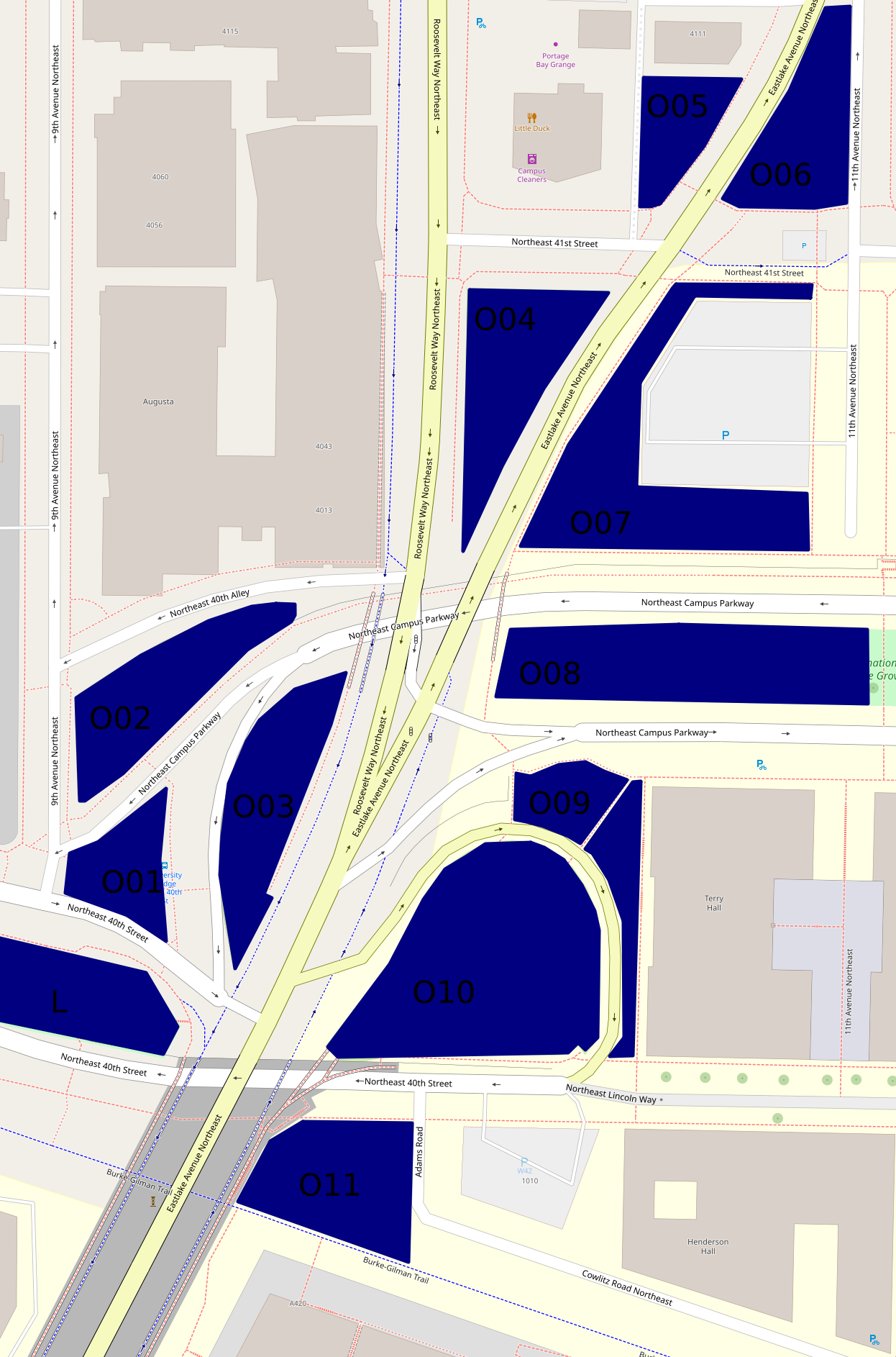

The hill off the bridge (O10 on second map)

This entirely grassy hill more or less between 40th St and Eastlake Ave has at its southern side a ramp off the bridge.  Of these areas, this was the first I visited on December 22nd, 2020.  But I'm choosing a photo taken October 29th:


The King County Parcel Viewer says that the northeastern part of this area, mid-right on that photo taken looking west, belongs to the university, the rest to the city (and probably specifically SDOT).  I have no idea why there's a crop circle in this land which isn't farmed.

The woods below the bridge (O11 on second map)

If I understand the parcel viewer correctly, this area is half university (east), half city (west).  It has a path between a very short Adams Road which I thought, when mapping northern West Campus, was a spur of Cowlitz Road, and the Burke-Gilman Trail.  This photo is from December 2020.


This woods appears to have been much used by homeless people.  Partly because of this, and partly because it's the least traffic-affected, most park-like, of these areas, I've taken more photos of it than of any of the rest, five versus one or two.  I'm surprised SDOT hasn't fenced it off too.  This photo is from October 29th.


The bus stop triangle (O01 on second map)

Behind the bus stop north of Peace Park is this small, path-broken woods.  It's between 40th St, 9th Ave, and two arms of Campus Parkway, and it's city-owned.  This photo, and all those until the last of these areas, are from October 16th.


Another wooded place (O02 on second map)

This one is between 40th Alley (according to OpenStreetMap), Campus Parkway, and 9th Ave, and is city-owned.


And another... (O03 on second map)

This one is between Campus Parkway and Roosevelt Way, and is also city-owned.


A grassy place (O04 on second map)

This is a triangle between Eastlake Ave, Roosevelt Way and 41st St.  It's university-owned.


And another... (O06 on second map)

This is a triangle, or really a series of triangles, between Eastlake Ave, 11th Ave, and the line of 41st St.  It appears to be city-owned.


A landscaped place (O05 on second map)

The land south of 4111 11th Ave NE, between Eastlake Ave and an alley, turns out not to belong to that building's owners, but to the university, at least according to the parcel viewer.  It's landscaped pretty fully, with trees, large stones at its borders, and slopes, a rather lovelier deterrent to campers than most I've seen.


And another... (O07 on second map)

This is the landscaping around a parking lot, between Eastlake Ave, 41st St, 11th Ave, and Campus Parkway.  It's university-owned.  From its southwest corner, the parking lot isn't even visible.


A block of Olympic Vista (O08 on second map)

Olympic Vista is the park that consists of the boulevard islands in the street Campus Parkway.  All clear?  I'd assumed Olympic Vista was university property; at least two aspects of its landscaping suggest the university's intervention; but according to the parcel viewer, it's all city land.  Anyway, what with all the grassy areas east of Eastlake, the woods at this end of Olympic Vista rather stand out.  However, I'll cover them with the rest of the park, in the next part, tomorrow.

Borderlands (O09 on second map)

Most of the land between Campus Parkway, Eastlake Ave, the road between those, and the university's Terry Hall is more or less green.  In the second map, it's split by a path.  That path is really there, and this area is grassy on the north side, landscaped on the east side.  Photos taken October 29th.


The University of Washington Farm at Mercer Court (P on first map)

That's the best name I can come up with for a park that's actually a bit bigger than the farm's fields.  Essentially all the land between the buildings of Mercer Court, a set of student apartment buildings, except building A to the north, is park.  Each space - between buildings B and C, C and D, and D and E - has the same series of elements:  fields from Pacific St to the stairs, a landing with more fields, more fields on top, then bushes, then benches.  From those benches, if not for the bushes, Portage Bay could probably be seen.  What differs is mainly the relative size of these elements.

Oh, the UW Farm?  It's real, it grows a few tons of food each year, and it supplies that food mostly to other places on campus but to some extent to outsiders as well.  (It offers various CSA plans, some of which appear to be sold to the public but not others; it supplies food to many campus venues and two I can't identify; it gives food to the UW Pantry, the University District Food Bank, and Fare Start.)  This is one of its main locations; we'll meet the other in East Campus someday, and a small new one in (north) Central Campus probably sooner, dear Diary.

I don't see a way for someone who can't handle stairs to get to the fields on the landings at all.  Also, I'm pretty sure getting to the stairs involves gravel paths in all three spaces.  (EDIT November 15:  Wrong.  In the western third, between buildings D and E, one can walk the whole way on pavement.)  So this park is relatively inaccessible to mobility-impaired people, such as me when in December 2020 I was pushing a cart; I took two not very interesting photos and went on.  So my single biggest concern on October 29, when I went back to the parks of that December 2020 hike, was this park.  I took photos on October 29 of each of the three bench areas, each of the three landings, and each of the three Pacific St views.  Fortunately, my preferred photos illustrate all three categories and all three spaces.


The benches photo is from between buildings D and E, the landing photo between buildings C and D, and the Pacific St photo between buildings B and C.

Well, that's all I have for you today, dear Diary.  Tomorrow I hope to tell you about Olympic Vista and the itty bitty parks near it, and then on Tuesday the buildings of southern West Campus.  But we'll just have to see.  Have a good night and good hours of days and nights until we meet again.


Tuesday, October 18, 2022

Three Hikes in Ravenna, part III: Southeast

Dear Diary,

Hello again.  This time we're back to just three hikes - Saturday, October 8; Wednesday, October 12; and Sunday, October 16.

Map:


On October 12, I went to properties listed in the City of Seattle's real property report for 2020.  (I prefer that because a bunch of properties of interest to me have been left out of later reports; it seems to have to do with the extent to which the city owns rather than leases the property.  The 2022 report has new problems, such that it's pretty nearly useless to me.  Sometime when it's raining too hard to go hiking, I should look at the now ten reports available online and do a detailed comparison.)

Ravenna P-Patch (A on map)

This P-patch is actually adjacent to a stairway, equivalent to 52nd St, which I've mentioned to you before, dear Diary, and even shown you a photo or two of, if I remember correctly.  Here's a photo meant to be of the P-patch, but I seem to have gotten rather too much of the stairway into it; if I can rely on my memory, this will have been because at least one person was gardening in the P-patch at the time.  Anyway, the photo:


Ravenna Woods (B on map)

This is an actual Seattle Department of Parks and Recreation park, but I don't think I've had much to tell you about it, dear Diary, because I experience it mostly as a dead end.  However, it turns out the park ends way north of where I thought it did, and most of my travel there has been on private property.  Anyway, I found an actual way to escape it this time, an obviously unofficial stairway adjacent to a building.  But I didn't want to risk that sleep and unsteady path a second time, when I finally thought of something to photograph.  Of course, here's an ordinary landscape, showing how much of this park is really its gravel trail:


But the first time I told you about this park, dear Diary, I mentioned some kids I thought homeless, who'd been cooking in front of a shed.  I'm pretty sure I found the shed, and I'm pretty sure, looking back, that it's actually on private property, which puts those kids' activity into a much more questionable light.  But anyway, here's a photo that includes part of the shed.


The Burke-Gilman Trail (C on map)

Something big has changed, at the Burke-Gilman Trail and NE 47th St.  A new apartment building decided to supply a new exit from the trail, a much more impressive thing than most exits:

There's also new signage:


including a feature I'll have a lot more to say about when I get back to downtown.  And finally, there's a new water fountain there.  I don't know if the money came from the building's developer or owner, but the fountain appears to me to be on park property, and is a design Seattle's parks department uses a lot:


Anyway, that's it for this page of my hike on October 8.

On October 12, I was mainly doing other things, but did photograph the whole of this next park.

17th Ave NE Center Strip

After the two boring photos I showed you in the previous part of this page, it dawned on me that I'd better change how I photographed the rest of the boulevard (which is what this is, just a fairly boring boulevard).  So here goes.  On the block from 55th to 52nd streets, I first tried an angle shot:


Then I found what I think is the first furniture put on this boulevard so far this academic year.  In "Ravenna Boulevard", I'd mentioned that as the clearest way of distinguishing between the blocks of this boulevard.


What I meant was furniture at least potentially useful to people visiting the boulevard islands, but since mentioning it in that page, I've walked 17th Ave many more times, and found other kinds of furniture also abandoned there.

Next, I figured since this tree on the island from 52nd to 50th was the best thing about that block, I should photograph it:


Over the last two blocks, the boulevard deteriorates, no doubt because it's more walked on, so I went back to conventional shots.  50th to 47th:


And 47th to 45th:


University Presbyterian Church (D on map)

On the 16th I visited things I'd noticed on Open Street Map while making earlier drafts of the maps I've been showing you, dear Diary.  This church is where I was sent by, I think, a staffer at another church, during one of the UW's snow closures.  At least at that time, it was allowing people to stay inside only a limited time, I think a quarter or half hour, I think so people sheltering there wouldn't too badly outnumber the staff.  On the 16th, I'd arrived much too late for their regular posted hours:


So I settled for trying for a postcard shot of the building:

Thanks, guys!

Another stairway park (E on map)

Fraternity Row infrastructure isn't exactly my idea of Ravenna, but actually, this parklet is just a block from Ravenna Woods.  Around the stairway, it's really overgrown:


But further south it flattens out, and there it's grassy:


All for tonight, dear Diary.  My landlord has started showing the room next door to me, so I probably can't keep writing so late much longer.  Tomorrow, I hope to write "Four Hikes in University Heights", and the page about the UW and visitors to its buildings.  A good night and day until then, dear Diary.


Tuesday, July 13, 2021

More details of yesterday's hike

Dear Diary,

Now that I can write in you from my laptop again, it turns out I already told you everything that mattered from Saturday's hike in "NE" and elsewhere.

My plan for yesterday's hike was actually more ambitious than just for "NW", but, well, I haven't hiked for you in summer before, dear Diary, and as I should've remembered from long summer hikes in years past, I don't move as fast when it's hot out.

Anyway, there are some things worth mentioning from the parks of southern "NW".

I'm sure you remember, dear Diary, but perhaps people who read you need to know that all the photos of running (or not) water fountains and open (or closed) restroom doors are in a public Google Drive folder.  All these photos are dated partly by including the relevant day's newspaper, and photos of those newspapers' front pages, for comparison, are in a sub-folder titled, um, "Front pages".

Golden Gardens Park

The park's hours are being cut, lumped in with Alki as a violent beach (apparently for good reason).  Before the pandemic, the park was open the usual schedule, 4 A.M. to 11:30 P.M.  During the lockdowns, it was one of the parks whose closing time changed every few months.  And now that that's apparently over, it isn't going back to normal, but to the less common standard schedule, 6 A.M. to 10 P.M.:


In more pleasant news, the external water supply that enables showering has definitely been turned on.  I saw the lower spigot used, and the amount of wet pavement, plus an actual puddle (not shown in this photo), near the spigots makes it plain:

The only water fountain I found that I couldn't elicit water from yesterday was here.  I'm pretty sure it wasn't running, and it had a hole in it that suggests it was disabled, but based on a previous photo, it has an unusual control:


Yesterday I didn't notice that control:

Okay, looks like I didn't ignore that dial, but rather it was actually missing.  The thing intruding into the lower photo's bottom is one of the earpieces on my glasses.

Loyal Heights Community Center and Playfield

At the Community Center, child care is still the main thing going on.  As a result, during summer at least, the entire upper half of the Playfield, which was a construction site when I last visited, has replaced construction's metal fences with orange plastic fences.  Nobody showed hostility to my photographing the water fountain.  But remember, children are still ineligible to get vaccinated, so for them, the pandemic is still in full swing.  I saw a sign urging that park visitors mask up and keep distant, and couldn't justify photographing it as an oddity.  Anyone who visits upper Loyal Heights Playfield anytime soon should mask up and keep distant.

On the other hand, this sign still stuck to the fence of the playfield proper, lower down, is surely past its time:


Is anyone really going to try to close a park in Seattle this summer because it's busy?

The water fountain attached to the Community Center, but in the lower half of the Playfield, is running, but its drain seems to be clogged.  The bowl was full the entire time I was there:

Webster Park

The water fountain which only supplied a trickle of water all last year is now actually running properly:


Seattle Public Library, Ballard branch

This time, the door to the restrooms appeared to be locked, as on a previous visit, but the security guy was right next to the door, ready to let people in.  On the other hand, that won't last much longer:


Now, naively, this looks like bad news.  But the restrooms at Ballard Community Center are open, if not too reliably on Sundays.  Or if one specifically wants library restrooms, the Green Lake branch is open Mondays, and the Northeast and University branches are open Sundays.  And,y'know, the libraries have been expanding their hours every couple of weeks; it's possible, if somewhat unlikely, that by July 21st, the Ballard branch will actually be open seven days per week.

Or, of course, people could just discipline themselves not to need restrooms on Sundays and Mondays.  Isn't self-discipline what homeless people need most anyway?

Speaking of downtown Ballard and homeless self-discipline, during my visit to Ballard Commons yesterday, I didn't hear any yelling or arguments.  How unusual.

The Burke-Gilman Trail

In Seattle Public Utilities's pseudo-map of street water fountains, one is listed with an address of "6049 Seaview Ave."  Now, assuming this to mean Seaview Ave NW, it turns out 6049 is a real address, quite a few yards north of the NW 60th St Viewpoint:


It's private property.  I didn't see any water fountains, street-style or no, in any of the areas more or less publicly accessible, nor on the verge.  There is a street fountain on Seaview, but it's half a mile south, near the NW 57th St Street End, and also on the Burke-Gilman Trail, which in the relevant block is the sidewalk on the south side of Seaview.

Mind, SPU has done something rather impressive here.  That fountain had been knocked over and eviscerated by metal thieves.  It takes some guts to put another in the exact same place.  But I don't understand why they're advertising the wrong location for it.  Metal thieves are very unlikely to consult SPU press releases to find targets.


Anyway, the new fountain's water is good.

OK, that seems to be it for yesterday's hike.  Something different soon, dear Diary.  Until then, happy days and good nights.


Monday, July 12, 2021

Today's hike: Most fountains running in southern NW

Dear Diary,

I'm writing this page on my phone using the app, which means I can't do much with it, so will keep this brief.

Today I went to Golden Gardens Park, Loyal Heights Community Center and Playfield, Salmon Bay Park, Webster Park, Ballard Playground, Ballard Commons, the parts of the Burke-Gilman Trail that include both the actual and the published locations of its western water fountain, NW 60th St Viewpoint (which is near the published location), Gilman Playground, Ross Park, and Sunset Place.  So I went to every park water fountain known to me in "NW" south of 85th (but not to the imaginary one at Baker Park on Crown Hill), every park restroom ditto, and here's what I found:

All fountains were running except the southern one at Golden Gardens Park.  I drank from those at Ballard Playground and on the Burke-Gilman Trail, and found their water OK.

All restrooms were open except Gilman Playground's (still posted), and Ross Park's, but that was at 8:40 P.M.  Even if park restrooms are keeping their advertised hours for summer - 7 A.M. to 9 P.M. - that's within a reasonable amount of leeway.

I'm beginning to hope that year two of the Durkan Drought is finally over, at least in North Seattle.

All for tonight, dear Diary.  Tomorrow I'd hoped to hike again, but I hurt too much, so should have plenty of time to tell you whatever else needs telling about the two latest hikes.

Saturday, July 10, 2021

Today's Hike: Many water fountains turned on in areas around the University

Dear Diary,

I have very little time left to tell you much about today's hike, so will summarise.

I went to Christie Park, University Playground, Cowen Park, Ravenna Park, the Burke-Gilman Trail (specifically, its eastern water fountain), Burke-Gilman Playground Park, and Laurelhurst Playfield and Community Center.  Also University Heights Plaza, which still has "sanican"s and an SPU sink, and Ravenna Boulevard, which still has no plumbing.

Restrooms - All open except, still, Cowen Park and University Playground.

Water fountains - All running except, still, Christie Park.  The double water fountain in the northeast of Laurelhurst Playfield is probably un-useable, however:  the lower bowl gives so little water I doubt it can be drunk, let alone fill a bottle, while the upper one overshoots its bowl so spectacularly, the same doubts hold.  The single water fountain in the same playfield's southwest was much cooler than the last time I tried it, last year, so evidently is just affected by the temperature in general, rather than specifically heated.

I found that I do still, after months of filtered tap water, like the water from Burke-Gilman Playground Park's water fountain.

I then went to another suburban library for another Korean drama (which I'd actually hoped to get from the first one last week), and found the water fountains still shut off, but the men's room was fine.

On returning downtown I looked for three of the street fountains listed on the pseudo-map that I hadn't known about.

The one at 298 James St, actually a little north of James on the west side of 3rd Ave, is running despite both kinds of damage I'd found in other running fountains:  its control-and-spout mechanism is wobbly, as at 5th & Olive Way, and its push button is uncapped, as at 1st & Pike.

I couldn't find one within a block of 200 Columbia St.

I did find one at 898 3rd Ave, that is, on the east side of 3rd Ave just south of Marion, but from the ingrained dirt in the bowl, I doubt it's run any time this past year, and it certainly wasn't running tonight.

The fountains at 2nd & Madison and at 3rd & Union were running, but I found I liked the taste of neither.

So things are looking up in North Seattle, but Seattle Public Utilities lied at least a little.  I'll take what I can get.  Good night, dear Diary.


Tuesday, June 8, 2021

Another RUNNING street fountain in today's hike

Dear Diary,

I went hiking for you today.  I don't have time to write for you today the page that occasioned that hike, but will try to get the stuff that I should write today so as to keep certain photos dated, that stuff I'll try to get written.

I went to:

  • Ballard Community Center (restrooms) and Playground (water fountain)
  • The Burke-Gilman Trail (no plumbing where I was then)
  • The Broadview branch of the Seattle Public Library (both)
  • Bitter Lake Playfield (both; I didn't look, today, at the Community Center there)
  • Northacres Park (both)
  • Virgil Flaim Park (water fountain)
  • Albert Davis Park (water fountain)
  • The Lake City branch of the Seattle Public Library (both)
  • The Burke-Gilman Trail again (water fountain)
  • Ravenna Park (both)
  • Ravenna Boulevard (neither)
  • Cowen Park (both)
  • Greenwood Ave N just south of N 85th St (water fountain I hadn't previously known of)
  • And back to N 45th St just east of Wallingford Ave N (water fountain)

I'll update the spreadsheet in the shared folder tomorrow - that is, this folder, dear Diary:

<https://drive.google.com/drive/folders/1cfrNdJI9NVY3ux7OoGI7B8Vg3Klq3liT?usp=sharing>

But I also set up another shared folder.  Community Centers and Pools are at least run by the same department as runs the parks, but libraries are a whole separate city department, so I set up a folder for libraries too:

<https://drive.google.com/drive/folders/10OrFusDTEySPSu7-Ophv35VCKZq-zAaF?usp=sharing>

In general, nothing has changed from what I previously told you, dear Diary (I want to emphasise that, in case there are new readers here), but here are the exceptions:

Ballard Community Center

You may remember that last time I went to this place, I considered its front doors too crowded to approach.  That wasn't the case this morning.


Here's a detail:


I doubt very much that the Community Centers are preparing to re-open to the general public, or at least those in North Seattle.  If they are, they're planning to surprise everyone.

Ballard Community Center, again

This time I found the restrooms at the back of the building, whose doors open outward, open.  I did not find yellow spots on the toilet seats.  However:


These are single-user stalls, each with one toilet, no urinal, one sink, one old-fashioned dryer that doesn't work, and one soap dispenser.  Neither sink splashed me, but one - the one with two buttons for calling the water - was under high enough pressure that it really wanted to.

Northacres Park

One of the single-user stalls there was closed for maintenance:


I remembered that I hadn't tested the sinks and dryers of those, so I washed my hands (I'd touched the toilet seats at Ballard Community Center, after all) and thus found that the dryer in the stall currently open (on the left as one faces the water fountains, north of the closed one) does work, but one has to push the button a few times to convince it to do so.

Virgil Flaim Park

I have to eat a whole lot of crow here.

I made a judgement last time I was at this park, that the damage to the water fountain was obviously the fault of homeless people who use bottles.  I was wrong, completely wrong.

I managed this time to take a photo that showed how the water now comes out.


Darn, no it doesn't, and I'll have to go back there.

Basically, the water comes from above the pipe I showed you last time, dear Diary, this pipe:


As a result, no, it isn't any better for filling bottles than it is for drinking from.  Turns out it comes from a hole in another pipe:


so no wonder it comes out diffusely.  I was unable to screw the pipe that's loose back into that hole, so I strongly suspect whoever sabotaged the water fountain removed something, anything from a washer on up.  Given how much other metal they left alone, I doubt this was a metal thief; I think the saboteur was someone who wanted to deny users of Virgil Flaim Park water, very probably specifically homeless users in the neighbourhood.  So I must apologise heartily to you, dear Diary, and to anyone who read the page I'll correct tomorrow:  I blamed the victim.

The Burke-Gilman Trail

This was, at the time, the only working water fountain I expected to encounter after Bitter Lake, it was hours later, I hadn't brought any bottles, and I was parched.  So I tried to drink from this fountain:


but found that the stream was so interrupted, whether by the wind or by something internal to the fountain, that I couldn't really drink from it.  At the time I wondered whether I was just out of the habit of drinking directly from water fountains.

Ravenna Boulevard

I will emphasise, again, dear Diary, that nothing has changed from what I previously told you unless I mention it here (or in a later embarrassed page).

The street fountain at 85th & Greenwood

One of the most frustrating aspects for me, dear Diary, of your readers never commenting, is that I get too many opportunities to be ignorant.  I spent a few days hiking past this intersection, in January, while I was at the Travelodge near there that saved my life (as recounted in "Escaping Green Lake Park", part II and "Fear of Rain"), and never noticed this fountain.  Unsurprising since at the time I couldn't wear glasses, but my point is, surely someone who's read you knew about that fountain and didn't tell us.  I have no idea how many more street fountains are scattered around North Seattle, running or otherwise, that I've missed; I only found this one because I happened to get off a bus there this evening.  So anyone who reads this now.  This is what a street water fountain in Seattle usually looks like:


Notice especially the stepped base.  This is something street fountains can do:


usually all year round when the city has a mayor who doesn't have some sort of personal hatred for homeless people.

So please, dear Diary, if you notice anyone reading you who knows of such fountains in North Seattle, beyond the former two, now one, on the Burke-Gilman Trail, the one on N 45th St out front of QFC, and this one I stumbled on today, could you please persuade them to say something?  Whether or not the fountains are currently running or the reader even knows one way or the other.  Thank you, very, very much.

On the strength of that (and two very long drinks from it) I went back to the one on 45th, but it's still off.

Good night, dear Diary.  I just signed a new lease that said I'd observe the quiet hours, and here I am typing in you during them again.  Good night.