Dear Diary,
This part concerns three places which I visited December 22nd, 2020; October 8th, this year; October 16th; and October 29th. Two of the places are large and complex, divided into lots of parts, so this is a pretty photo-heavy part of this page.
Map:

The Burke-Gilman Trail and the Land under University Bridge (N on map)
Most of the Burke-Gilman Trail in this entire region - that is, from the water to NE 65th St and from I-5 to 25th Ave NE - is on land owned by the University of Washington. However, the City of Seattle Department of Transportation owns the land under the University Bridge, including that chunk of the trail.
Before the pandemic, the part of the trail under the bridge was a favoured hangout for local teens. Up the slope, locally north, there were and are concrete blocks attached to the concrete pavement; opposite that area is a flat place, with a sign saying "The Wall of Death", presumably referring to the difficulty of skateboarding the slope opposite. On the rare occasions that I walked along that part of the trail, I sometimes stopped and put my satchels down on the dry parts of the flat area, but sometimes couldn't, because there were so many teens around.
During the early phase of the pandemic, a homeless encampment formed in that flat place.
By December 2020, that encampment had already been swept:

And a fence put up. That fence is still there:

Dear Diary, I've recently been reading Skid Road: On the Frontier of Health and Homelessness in an American City by Josephine Ensign, Baltimore: Johns Hopkins University Press, c2021. This is not actually a history of homelessness in Seattle, as a review had led me to believe; Ensign, herself a nursing professor, is too interested in the history of health care for the homeless, as her subtitle already makes clear, to give anything like a full account of the broader history. But she does make it clear that Seattle has always had homeless people. So those who have claimed in recent years to be trying to end homelessness here are struggling against history.
But I've had a great idea. A way to really end homelessness in Seattle. All we have to do is fence off all the public property. Not just this flat place where some homeless people recently had the audacity to camp, but the whole trail. All the sidewalks. All the streets. Every bit of it. I'm quite sure that by the time the job was done, there would be no homeless people left in Seattle.
Of course, nobody else would be alive here either. I think the decisive moment would come when the city's water supply shut down because the people trapped in the relevant places starved. After that, the end would come in a few days.
But isn't that a small price to pay, to solve a problem that's already lasted nearly two centuries?
Unfortunately, SDOT hasn't yet tried to go that far. The Wall of Death itself, as opposed to its sign, remains open:

though I would imagine some skateboarding moves could be difficult with that fence in the way up top.
One thing that has changed is that a graffito I saw in December 2020 is now gone:

Areas around University Bridge (O on map)
Besides Peace Park (L on the map, and covered in the previous part), there are eleven other green areas that form an only mildly discontinuous belt around and north of the place where the University Bridge joins North Seattle's street grid.
Here's a map, which differs somewhat from the map up above as well as being on a much larger scale:
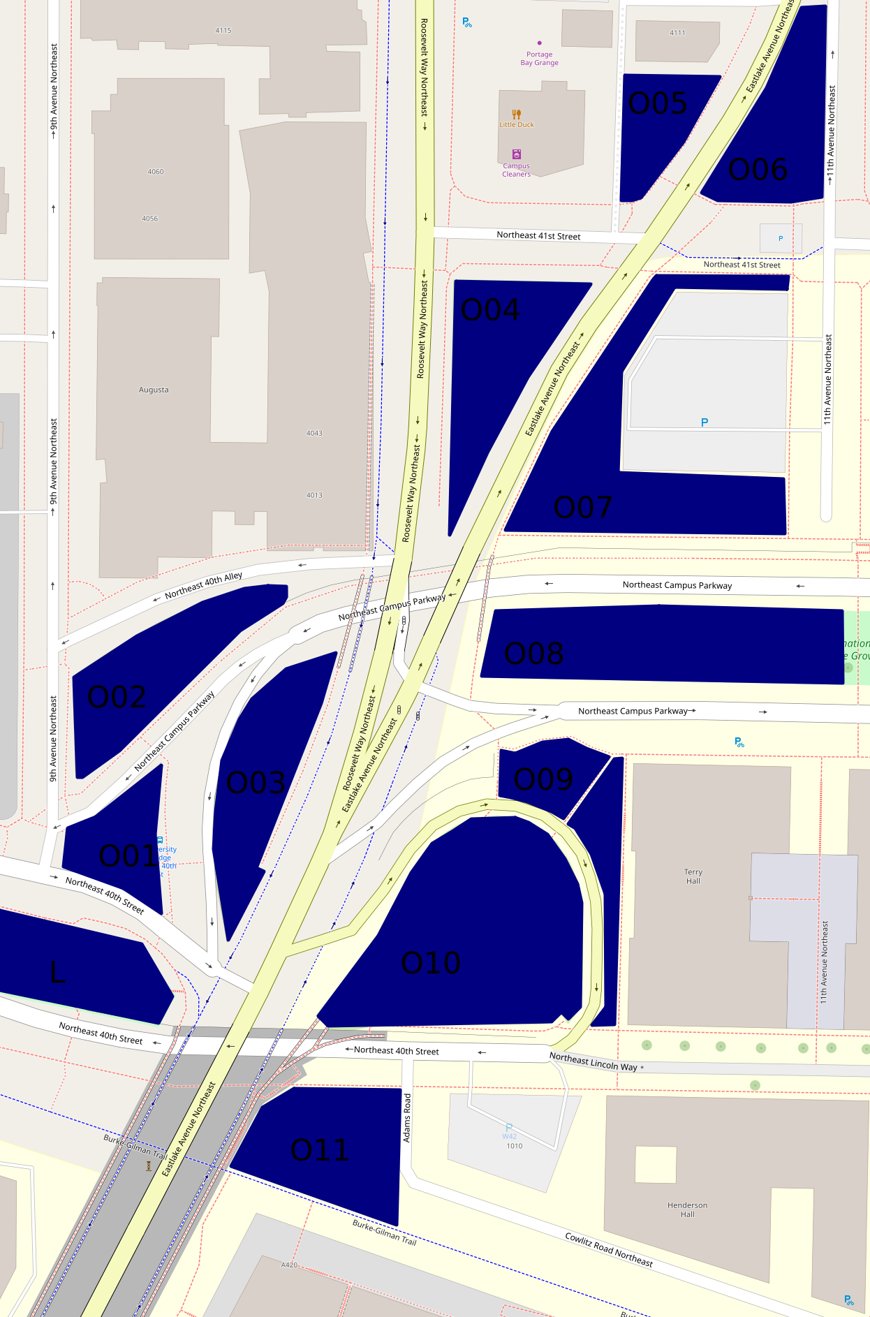
The hill off the bridge (O10 on second map)
This entirely grassy hill more or less between 40th St and Eastlake Ave has at its southern side a ramp off the bridge. Of these areas, this was the first I visited on December 22nd, 2020. But I'm choosing a photo taken October 29th:

The King County Parcel Viewer says that the northeastern part of this area, mid-right on that photo taken looking west, belongs to the university, the rest to the city (and probably specifically SDOT). I have no idea why there's a crop circle in this land which isn't farmed.
The woods below the bridge (O11 on second map)
If I understand the parcel viewer correctly, this area is half university (east), half city (west). It has a path between a very short Adams Road which I thought, when mapping northern West Campus, was a spur of Cowlitz Road, and the Burke-Gilman Trail. This photo is from December 2020.

This woods appears to have been much used by homeless people. Partly because of this, and partly because it's the least traffic-affected, most park-like, of these areas, I've taken more photos of it than of any of the rest, five versus one or two. I'm surprised SDOT hasn't fenced it off too. This photo is from October 29th.

The bus stop triangle (O01 on second map)
Behind the bus stop north of Peace Park is this small, path-broken woods. It's between 40th St, 9th Ave, and two arms of Campus Parkway, and it's city-owned. This photo, and all those until the last of these areas, are from October 16th.

Another wooded place (O02 on second map)
This one is between 40th Alley (according to OpenStreetMap), Campus Parkway, and 9th Ave, and is city-owned.

And another... (O03 on second map)
This one is between Campus Parkway and Roosevelt Way, and is also city-owned.

A grassy place (O04 on second map)
This is a triangle between Eastlake Ave, Roosevelt Way and 41st St. It's university-owned.

And another... (O06 on second map)
This is a triangle, or really a series of triangles, between Eastlake Ave, 11th Ave, and the line of 41st St. It appears to be city-owned.

A landscaped place (O05 on second map)
The land south of 4111 11th Ave NE, between Eastlake Ave and an alley, turns out not to belong to that building's owners, but to the university, at least according to the parcel viewer. It's landscaped pretty fully, with trees, large stones at its borders, and slopes, a rather lovelier deterrent to campers than most I've seen.

And another... (O07 on second map)
This is the landscaping around a parking lot, between Eastlake Ave, 41st St, 11th Ave, and Campus Parkway. It's university-owned. From its southwest corner, the parking lot isn't even visible.

A block of Olympic Vista (O08 on second map)
Olympic Vista is the park that consists of the boulevard islands in the street Campus Parkway. All clear? I'd assumed Olympic Vista was university property; at least two aspects of its landscaping suggest the university's intervention; but according to the parcel viewer, it's all city land. Anyway, what with all the grassy areas east of Eastlake, the woods at this end of Olympic Vista rather stand out. However, I'll cover them with the rest of the park, in the next part, tomorrow.
Borderlands (O09 on second map)
Most of the land between Campus Parkway, Eastlake Ave, the road between those, and the university's Terry Hall is more or less green. In the second map, it's split by a path. That path is really there, and this area is grassy on the north side, landscaped on the east side. Photos taken October 29th.


The University of Washington Farm at Mercer Court (P on first map)
That's the best name I can come up with for a park that's actually a bit bigger than the farm's fields. Essentially all the land between the buildings of Mercer Court, a set of student apartment buildings, except building A to the north, is park. Each space - between buildings B and C, C and D, and D and E - has the same series of elements: fields from Pacific St to the stairs, a landing with more fields, more fields on top, then bushes, then benches. From those benches, if not for the bushes, Portage Bay could probably be seen. What differs is mainly the relative size of these elements.
Oh, the UW Farm? It's real, it grows a few tons of food each year, and it supplies that food mostly to other places on campus but to some extent to outsiders as well. (It offers various CSA plans, some of which appear to be sold to the public but not others; it supplies food to many campus venues and two I can't identify; it gives food to the UW Pantry, the University District Food Bank, and Fare Start.) This is one of its main locations; we'll meet the other in East Campus someday, and a small new one in (north) Central Campus probably sooner, dear Diary.
I don't see a way for someone who can't handle stairs to get to the fields on the landings at all. Also, I'm pretty sure getting to the stairs involves gravel paths in all three spaces. (EDIT November 15: Wrong. In the western third, between buildings D and E, one can walk the whole way on pavement.) So this park is relatively inaccessible to mobility-impaired people, such as me when in December 2020 I was pushing a cart; I took two not very interesting photos and went on. So my single biggest concern on October 29, when I went back to the parks of that December 2020 hike, was this park. I took photos on October 29 of each of the three bench areas, each of the three landings, and each of the three Pacific St views. Fortunately, my preferred photos illustrate all three categories and all three spaces.


The benches photo is from between buildings D and E, the landing photo between buildings C and D, and the Pacific St photo between buildings B and C.
Well, that's all I have for you today, dear Diary. Tomorrow I hope to tell you about Olympic Vista and the itty bitty parks near it, and then on Tuesday the buildings of southern West Campus. But we'll just have to see. Have a good night and good hours of days and nights until we meet again.
No comments:
Post a Comment