Showing posts with label cart. Show all posts

Saturday, August 29, 2026

Under Construction, part VI: Meridian Playground Before

Dear Diary,

I've visited Meridian Playground a bunch of times, recently, waiting for the fences to go up.  I know, now, why they haven't.  But first some context.

Meridian Playground is a fairly big park between N 47th St, Meridian Ave N, the Good Shepherd Center, and N 50th St.  Unlike the past several projects I've written about, I have no real complaints with regard to this one, although this is the main project that led me to say Access is a magic word to park project managers.

"This project aims to make site improvements to the play area ...  The project also improves accessibility to the play area and restrooms.

"Most components of the play area were constructed in the early 1980s, and revised in 2002, and some equipment was replaced ... in 2011."

In other words, this is some seriously tired playground equipment, older than most of the kids' parents, and on my first visit July 23rd, it looked tired, too.

It was easy to tell which was the equipment new in 2011, too:


What I couldn't figure out, though, was how the project was going to make the playground more accessible.  See all those curbs in the foreground of this photo?  There are curbs aplenty in this place, and walls, and even stairs:

The thing that was going to serve Access was a new path between the Good Shepherd Center parking lots and the area where the playground and restrooms are.  So on July 30th, I went planning to blaze a trail through the woods, and was completely gobsmacked to discover that this path already exists.  Not least because that meant I need never have damaged my carts on the crude pavement of the N Bagley St entrance.

But here's the thing:  Most Access projects described at the parks website emphasise that standards change, and what was good enough in the 1990s isn't good enough today.  Well, but actually, I'm pretty sure that path wasn't wide enough for the 1990s either.  If you go from the park side, it's plenty wide, right up until about where the park/center boundary must be, and then it narrows drastically.  Sure, my cart would fit, but I'm not sure I've ever seen a wheelchair that would.

So even if, as it sounds like at the project page and in its linked documents (4 page PDF), they leave all those walls, curbs and stairs where they are, there's still a solid win for real access in making the restrooms wheelchair accessible.  And they're also planning to remodel the restrooms to make them work better for people with that kind of disability too.

Still ...  The Good Shepherd Center has north and south parking lots.  There are, of course, no stairs at their entrances.  But the Center warns pedestrians not to use those entrances - and of course, there are stairs at the middle path.  Three shallow steps, as if to say "No" just to be difficult.

So yes, I still think Access is a magic word for Parks project managers.

Anyway, none of that is why the project is behind schedule.  It's behind schedule because of a stupendously successful marketing campaign.

"Picnic in the Park".  Who knew?

It turns out that the Wallingford Farmers Market, held in Meridian Playground, is the closest to my house, somewhat nearer than the U-District one.  The fact that I hadn't known this, dear Diary, tells you all you need to know about how much attention I pay to farmers markets, which I could never afford in my first years in Seattle.

So there I was, on August 19th, and so were hundreds of other people, including a purely amazing number of children.  I think the average age in that park was probably not much over 20.  And that tired old playground equipment was in glory.

So I predicted then, and the project page already said before July ended, a start date of November for this project, after the market shuts down for the winter.  I don't envy the construction workers.

Well, dear Diary, I'd hoped to tell you the much more boring story of construction in Woodland Park tonight as well, but I'd better go back to real property reports instead.  Until tomorrow, then, dear Diary. 


Tuesday, August 4, 2026

A detail note about labels

Dear Diary,

It's strange to think it now, but for most of your life, I've been housed.

For some time before then, I'd been pushing shopping carts, not stolen from a grocery store, but purpose-bought.  Your pages that I wrote while homeless include endless complaints about these carts.

Once I was housed, I got a laptop, and discovered Blogspot's categorisation system, which it calls "labels".  It doesn't show its labels to readers on phones, you see.  Soon I re-read all of you, dear Diary, and set up a system of labels.  And all those complaints about carts got the label "cart".

Unfortunately, so did less me-specific remarks about things that impede some people's ability to get around.  This is a particular problem for writing about the Seattle Department of Parks and Recreation's love of "access".

Now I've finally separated these two things.  Many pages are still labelled "cart", some are now labelled "mobility", and a few have both labels.

Happy days and nights, dear Diary! 

Saturday, November 12, 2022

Six Hikes in Brooklyn, part IV: Centre

Dear Diary,

This part concerns three places which I visited December 22nd, 2020; October 8th, this year; October 16th; and October 29th.  Two of the places are large and complex, divided into lots of parts, so this is a pretty photo-heavy part of this page.

Map:


The Burke-Gilman Trail and the Land under University Bridge (N on map)

Most of the Burke-Gilman Trail in this entire region - that is, from the water to NE 65th St and from I-5 to 25th Ave NE - is on land owned by the University of Washington.  However, the City of Seattle Department of Transportation owns the land under the University Bridge, including that chunk of the trail.

Before the pandemic, the part of the trail under the bridge was a favoured hangout for local teens.  Up the slope, locally north, there were and are concrete blocks attached to the concrete pavement; opposite that area is a flat place, with a sign saying "The Wall of Death", presumably referring to the difficulty of skateboarding the slope opposite.  On the rare occasions that I walked along that part of the trail, I sometimes stopped and put my satchels down on the dry parts of the flat area, but sometimes couldn't, because there were so many teens around.

During the early phase of the pandemic, a homeless encampment formed in that flat place.

By December 2020, that encampment had already been swept:


And a fence put up.  That fence is still there:


Dear Diary, I've recently been reading Skid Road:  On the Frontier of Health and Homelessness in an American City by Josephine Ensign, Baltimore:  Johns Hopkins University Press, c2021.  This is not actually a history of homelessness in Seattle, as a review had led me to believe; Ensign, herself a nursing professor, is too interested in the history of health care for the homeless, as her subtitle already makes clear, to give anything like a full account of the broader history.  But she does make it clear that Seattle has always had homeless people.  So those who have claimed in recent years to be trying to end homelessness here are struggling against history.

But I've had a great idea.  A way to really end homelessness in Seattle.  All we have to do is fence off all the public property.  Not just this flat place where some homeless people recently had the audacity to camp, but the whole trail.  All the sidewalks.  All the streets.  Every bit of it.  I'm quite sure that by the time the job was done, there would be no homeless people left in Seattle.

Of course, nobody else would be alive here either.  I think the decisive moment would come when the city's water supply shut down because the people trapped in the relevant places starved.  After that, the end would come in a few days.

But isn't that a small price to pay, to solve a problem that's already lasted nearly two centuries?

Unfortunately, SDOT hasn't yet tried to go that far.  The Wall of Death itself, as opposed to its sign, remains open:


though I would imagine some skateboarding moves could be difficult with that fence in the way up top.

One thing that has changed is that a graffito I saw in December 2020 is now gone:


Areas around University Bridge (O on map)

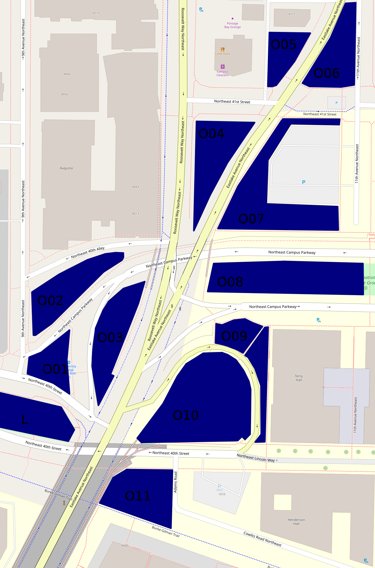
Besides Peace Park (L on the map, and covered in the previous part), there are eleven other green areas that form an only mildly discontinuous belt around and north of the place where the University Bridge joins North Seattle's street grid.

Here's a map, which differs somewhat from the map up above as well as being on a much larger scale:


The hill off the bridge (O10 on second map)

This entirely grassy hill more or less between 40th St and Eastlake Ave has at its southern side a ramp off the bridge.  Of these areas, this was the first I visited on December 22nd, 2020.  But I'm choosing a photo taken October 29th:


The King County Parcel Viewer says that the northeastern part of this area, mid-right on that photo taken looking west, belongs to the university, the rest to the city (and probably specifically SDOT).  I have no idea why there's a crop circle in this land which isn't farmed.

The woods below the bridge (O11 on second map)

If I understand the parcel viewer correctly, this area is half university (east), half city (west).  It has a path between a very short Adams Road which I thought, when mapping northern West Campus, was a spur of Cowlitz Road, and the Burke-Gilman Trail.  This photo is from December 2020.


This woods appears to have been much used by homeless people.  Partly because of this, and partly because it's the least traffic-affected, most park-like, of these areas, I've taken more photos of it than of any of the rest, five versus one or two.  I'm surprised SDOT hasn't fenced it off too.  This photo is from October 29th.


The bus stop triangle (O01 on second map)

Behind the bus stop north of Peace Park is this small, path-broken woods.  It's between 40th St, 9th Ave, and two arms of Campus Parkway, and it's city-owned.  This photo, and all those until the last of these areas, are from October 16th.


Another wooded place (O02 on second map)

This one is between 40th Alley (according to OpenStreetMap), Campus Parkway, and 9th Ave, and is city-owned.


And another... (O03 on second map)

This one is between Campus Parkway and Roosevelt Way, and is also city-owned.


A grassy place (O04 on second map)

This is a triangle between Eastlake Ave, Roosevelt Way and 41st St.  It's university-owned.


And another... (O06 on second map)

This is a triangle, or really a series of triangles, between Eastlake Ave, 11th Ave, and the line of 41st St.  It appears to be city-owned.


A landscaped place (O05 on second map)

The land south of 4111 11th Ave NE, between Eastlake Ave and an alley, turns out not to belong to that building's owners, but to the university, at least according to the parcel viewer.  It's landscaped pretty fully, with trees, large stones at its borders, and slopes, a rather lovelier deterrent to campers than most I've seen.


And another... (O07 on second map)

This is the landscaping around a parking lot, between Eastlake Ave, 41st St, 11th Ave, and Campus Parkway.  It's university-owned.  From its southwest corner, the parking lot isn't even visible.


A block of Olympic Vista (O08 on second map)

Olympic Vista is the park that consists of the boulevard islands in the street Campus Parkway.  All clear?  I'd assumed Olympic Vista was university property; at least two aspects of its landscaping suggest the university's intervention; but according to the parcel viewer, it's all city land.  Anyway, what with all the grassy areas east of Eastlake, the woods at this end of Olympic Vista rather stand out.  However, I'll cover them with the rest of the park, in the next part, tomorrow.

Borderlands (O09 on second map)

Most of the land between Campus Parkway, Eastlake Ave, the road between those, and the university's Terry Hall is more or less green.  In the second map, it's split by a path.  That path is really there, and this area is grassy on the north side, landscaped on the east side.  Photos taken October 29th.


The University of Washington Farm at Mercer Court (P on first map)

That's the best name I can come up with for a park that's actually a bit bigger than the farm's fields.  Essentially all the land between the buildings of Mercer Court, a set of student apartment buildings, except building A to the north, is park.  Each space - between buildings B and C, C and D, and D and E - has the same series of elements:  fields from Pacific St to the stairs, a landing with more fields, more fields on top, then bushes, then benches.  From those benches, if not for the bushes, Portage Bay could probably be seen.  What differs is mainly the relative size of these elements.

Oh, the UW Farm?  It's real, it grows a few tons of food each year, and it supplies that food mostly to other places on campus but to some extent to outsiders as well.  (It offers various CSA plans, some of which appear to be sold to the public but not others; it supplies food to many campus venues and two I can't identify; it gives food to the UW Pantry, the University District Food Bank, and Fare Start.)  This is one of its main locations; we'll meet the other in East Campus someday, and a small new one in (north) Central Campus probably sooner, dear Diary.

I don't see a way for someone who can't handle stairs to get to the fields on the landings at all.  Also, I'm pretty sure getting to the stairs involves gravel paths in all three spaces.  (EDIT November 15:  Wrong.  In the western third, between buildings D and E, one can walk the whole way on pavement.)  So this park is relatively inaccessible to mobility-impaired people, such as me when in December 2020 I was pushing a cart; I took two not very interesting photos and went on.  So my single biggest concern on October 29, when I went back to the parks of that December 2020 hike, was this park.  I took photos on October 29 of each of the three bench areas, each of the three landings, and each of the three Pacific St views.  Fortunately, my preferred photos illustrate all three categories and all three spaces.


The benches photo is from between buildings D and E, the landing photo between buildings C and D, and the Pacific St photo between buildings B and C.

Well, that's all I have for you today, dear Diary.  Tomorrow I hope to tell you about Olympic Vista and the itty bitty parks near it, and then on Tuesday the buildings of southern West Campus.  But we'll just have to see.  Have a good night and good hours of days and nights until we meet again.


Wednesday, April 28, 2021

Hikes 11C and 13: Matthews Beach

Dear Diary,

I'm sorry it's taken me so long, but this is the last page about my January hikes that I have to write.  It also covers the second hike I took housed.

Hike 11C - January 22

As I left Burke-Gilman Playground Park on January 22, the sun was already beginning to go down.  Fortunately, the Burke-Gilman Trail goes, well, not straight, but anyway directly from BGPP to Matthews Beach, so it was a straightforward trip.  All the same, I was racing against time, and ultimately lost.

I didn't even try to photograph the best face of the restroom building.  Those are "sanican"s that are there, but in this case the map I was checking also claimed the restroom was open.  True, I don't remember whether it said one restroom was open, or two were, and that matters because:


one restroom is still boarded up.  The other is not, but I was unable to open it.


I figured maybe someone was camping in it.  It was only 5:50 P.M., after all, and so far too early for a restroom to be locked for the night.  So I waited for someone from the Seattle Department of Parks and Recreation's maintenance department to show up to lock this one solitary restroom door in far northeastern Seattle that should need locking.

See, this building actually has two pairs of restrooms in it.  I've just shown you, dear Diary, the closed doors of the all-gender single stall restrooms, but what about the multi-user rooms that also feature showers, on the other side?  Well, those are only supposed to open in summer, like the Bathhouse Theater's in Green Lake Park, but unlike those, these don't also open in winter:


So Matthews Beach only had one room meant to be open.  Meadowbrook Playfield had none.  It was probably parks personnel staffing Meadowbrook Pool's restroom access, but probably not maintenance people.  Little Brook Park has the only restroom (singular) in Lake City, it was closed...  Basically, that restroom in Matthews Beach was the only one between Magnuson Park and Northacres Playfield that was supposed to be open.  But it's vulnerable to camping, and I found it locked.

So I stayed, growing increasingly uncomfortable, until about 7:50 P.M.  No parks personnel drove anywhere near the restroom building in that time.  I eventually had to use a "sanican" myself, and having taken off my mask while waiting, forgot to put it back on.  This led to a conversation with a fellow homeless man, a friendlier conversation than one would expect given my mistake.  But still no parks personnel.

After I gave up, I started pushing my cart, which had performed splendidly in the race despite our losing it, down Sand Point Way.  About halfway, right on schedule, the cart's right front wheel jumped off its spokes, just as I could have expected.  I didn't understand the way the back left wheel was malfunctioning, so I didn't know whether changing the wheel would fix the problem, but I did know that I'd had two good front wheels on the cart I'd thrown away about two weeks before.  Oops.  That left back wheel responded to the situation by behaving itself for an hour or so before getting back to its waywardness.

I lived on the streets of Seattle for about six years lugging everything I thought I needed around in satchels that were exposed to the rain and that I couldn't put down while it rained.  I wasn't sure I could stand to go back to that way of life, but more to the point, I needed to carry a lot more during the lockdowns than I had previously.  Sanitiser, detergent, paper towels, lots more books ...  By this point I'd already been co-operating for some time with Maia Robbins, who organised the GoFundMe that's now housed me, but this was the first time I had to face seriously the fact that I couldn't realistically continue living homeless, whether or not the GoFundMe went anywhere.  Not while COVID-19 shut everything down.

So, dear Diary, I didn't hike for you after that until I was housed.  The first hike I took then, hike 12, is the subject of another page, but I did eventually get back to Matthews Beach.

I'd had plenty of time to think about it.  I could see that a parks maintenance guy might think it made no sense to drive all that way to unlock one room, that would probably be blocked by a camper anyway, and then lock it again that night.  I could sympathise.

But that's looking at things exactly backwards.  It is not appropriate to sympathise with the idea that the less someone does, the less one should expect them to do.  Meadowbrook Playfield's restrooms apparently didn't have to close.  Why, then, were they closed?  The shower restrooms at Matthews Beach are in the same building as the ones that were supposed to be open.  And they presumably have access to hot water.  So they're quite obviously winter-safe; why weren't they opened?  Reduce the options to the two all-gender single-stall rooms, and board one of those up, and it can look realistic to forget the other.  But the parks department had no reason at all, in forgetting the other, to forget a significant percentage of the city.

Hike 13 - April 3

Anyway, I went back to Matthews Beach.  I didn't arrive much earlier - 5:30 P.M. - but it was enough later in the year that the sun hadn't yet set.

I stopped along the way to take photos of the nearby bit of the Thornton Creek complex.  Since Matthews Beach is where Thornton Creek enters Lake Washington, the creek there is probably the main, unified creek, but I haven't worked on your "Land and Water" series for months, dear Diary, and am not sure.  In any event, I'd taken pictures of it months earlier and then deleted them by mistake, so although I'd written about "Chinook Passage Natural Area" May 6 in "Go North, Aging Man!" and December 1 in "To the Beaches!", I'd yet to show you, dear Diary, a photo.  Well, here are three.

In several places, gaps in the woods that weren't there last May, as best I recall, allow one to see inside the forest a fair way.  My previous attempt to capture that effect in a photo was a dismal failure, and I'm not sure this is any better, but:


Another such gap opened up a view of the creek, although I'm not at all sure my photo actually caught that:


Although it's been several years since the park got a more specific name, its sign hasn't been updated:


Anyway, I finally got back to Matthews Beach, to find the same situation as before, only sunlit.  This time I made extra sure by staying close to the restroom doors - the ones that were supposedly being unlocked and locked this winter - as much as I could, and almost always staying within sight of them.  No parks personnel had shown up by the time I left around 7:45 P.M.

I did move away from the specific door I was observing to take pictures, this time, of all the things I was supposed to on the January hikes.  The building's best face, first.  This building, like the beach one at Golden Gardens, is so extremely wide, or long, that I had to back very far up to take this shot, and I'm not sure how much of the building can actually be seen:


The restrooms that were supposed to be open:


Oh, good.  I'd hoped to show the latch in the photo just above, and it looks like that worked.

The restrooms that weren't supposed to be open, except in an alternate universe in which Seattle's government had thought about how best to serve the public, and I do mean the public - Matthews Beach isn't in an area where homeless people could plausibly live - anyway, the restrooms that weren't supposed to be open this winter, but should've been:


The unobtrusive back door to that women's room that I found for the first time that night:


When I caught them in their lies about Sandel Playground and Loyal Heights Community Center, the places where they'd shown restrooms open that were not, in fact, open, without "sanican"s, the map's makers hurried to correct those.  Of course, the lies about restrooms being open with "sanican"s present weren't really lies, by the warped thinking behind the map, because its fine print didn't actually say those rooms were open; the map wasn't corrected in this respect all winter.  But as far as I know, the map's fine print did say Matthews Beach's actual restrooms were open all winter, and as best I can tell, none were.  Sometime in the two months I was away, someone could have asked the maintenance people whether they were really driving all that way, and fixed the map.  I sent the information by e-mail, long before telling you tonight, dear Diary.  But nobody bothered.

An alternative hypothesis:  Traffic in northeastern Seattle this pandemic winter was so unusually bad that the maintenance guys had to lock Matthews Beach at 5 P.M. to get it done at all.  Um, right.  I want some of that green cheese the moon is made of, too.

The "sanican"s by day:


A sign that I photographed as I left, so I'd know how late it had been, that someone had taped over enough of that it communicated nothing at all:


Would that that map had met the same fate.

Good night, dear Diary.  Tomorrow I hope to tell you about hikes 12 and 14, both made while housed, and neither one really related to checking the map any more.  Until then.


Saturday, April 24, 2021

Hike 11A: Near Northwest

Dear Diary,

This page exists mainly because of how I got to Ballard on January 20 (correction:  January 21).  While there, on January 21 (hence hike 11, but correction:  January 22), I took a few photos related to hygiene for homeless people such as (then) myself, but those won't take long to explain to you, and I could easily have fit them into "Hike 8C", from April 4.  The hike there, however, is part of the story of how I got ready to give up homelessness, and is therefore the main topic here, and what I couldn't find a way to fit into the earlier pages.

I didn't want to go all the way downhill and south to the path I'd taken before, via Fremont and Leary Way.  I had two stops to make - at the Urban Rest Stop's Ballard branch, and at Ballard Commons - both of which are in downtown Ballard.  I knew I couldn't leave Green Lake and Woodland Parks via West Green Lake Way N to N 65th St, but figured I could take Green Lake Way N (note the lack of an initial direction), or maybe Aurora Ave N, I forget, south to N 46th St, and then follow that as it turned into N Market St and finally NW Market St.

The sun had already set when I started, and that's the only explanation I have for what happened next.  You see, dear Diary, from about Palatine Ave N to about Baker Ave NW, along the north sidewalk of Market St, the vegetation on both sides of the sidewalk very often encroaches onto it.  I walked this stretch again a week or two ago to verify by daylight, and someone has obviously cut the overgrowth back for a stretch near Palatine, but in general, it's still visible.  Now, I'm out of the habit of pushing my cart, so maybe I've forgotten how wide it really is, but in any event I can't explain what I experienced that night.

Basically, I thought I was pushing my cart through a jungle that had just about engulfed the sidewalk.  Most of the time, at least one back wheel was on greenery, not pavement.  It was a horrible experience, made more so because under these circumstances the left back wheel found a way to overcome its construction, which should have prevented this, and come into contact with the cart's structure every time it turned, which of course both made noise and slowed me down.

Now, this particular shopping cart is wonderfully designed for homeless users, with sturdy steel spokes so the wheels can stand up to heavy use, sturdy steel frame ditto...  This of course doesn't suit modern manufacturing at all, so they had to build it with planned obsolescence.  After a year or so, the rivets start to come loose.  But they also make the buyer spend money on it more immediately.  The back wheels my first cart came with were so designed that after about 20 miles, they'd start to brush against the structure.  (Replacement wheels sold separately have a simple fix to prevent this.)  Also, if one uses it on four wheels, at about the same distance one of the front wheels flies off its spokes.

The back wheel problem is far more important, so on my second and third carts of this brand, the seller had installed the necessary fix up front and raised the price to compensate.  This is why what the left wheel was doing was, and remains, a mystery to me.  But it meant I had to run the cart on all four wheels for the hiking remaining in January, and you can probably already predict, dear Diary, what consequence that had.

Anyway, finally the overgrowth that so mystifyingly obstructed me ended, and I continued down Market.  At which point I realised that I proposed to sleep in Ballard, a place whose homeless population, like its housed population, strikes me as amazingly entitled and somewhat dangerous.  I finally figured maybe Marvin's Garden would be a safe place to crash.

But on the way I found Bergen Place, which I've maligned so much in the past that I had to go back to Ballard specifically to correct myself.  (In "History and Parks" part II, June 25.)  I'm still not crazy about it, but it has a bunch of well-spaced wooden benches, only two of which were occupied that night, and one of those people got up and left soon after I arrived.  And it's sort of screened from the main street, i.e. Market St.  So I settled in, ate supper, read some, and went to sleep.

So I was in position to meet the appallingly early hours kept by my first target:

The Urban Rest Stop, Ballard branch

As noted in "Hike 8C", the first time I went to Ballard on that hike, I'd dawdled too long trying to economically stimulate Fremont, and all I found was this charity location's closed doors.  The resulting photo is probably as good a postcard shot as I could've taken, so I'll see if I can show it to you again here, dear Diary.


Wow, so many things about writing you are easier on a laptop than on a phone, dear Diary.

Anyway, here's a photo that shows the open door one actually finds if one gets there during its open hours:


Seemed like a nice place, but it never made sense for me to try to shower in Ballard, so I haven't had occasion to deal with it.

Ballard Commons

Ever since I'd found (in "Hike 8C") that the "Portland Loo" actually had a toilet in it, and was not just a fancier "sanican", I'd been dithering over what the word "restroom" means.  I decided that one relevant issue was the sanitiser "sanican"s supply (when it hasn't been stolen).  Since I've until recently always lived far east of Ballard, I've tried never to go there without more than one reason to, and this was the second reason that got me to go do justice to the Urban Rest Stop there.  Does the "Portland Loo" have sanitiser?

Well, it's designed to:


I took another photo, but to be honest can't remember what it's meant to show.


Looks like I was pointing out either that the lock worked, or that it didn't.  Beats me.  It seems there's always a loose end after my every trip to Ballard, and this was this trip's loose end.

Anyway, dear Diary, as I said, not much to these photos.  Tomorrow I'll tell you about the one area left, my home then, the near (i.e., southern) NE.  And there's one park left after that.  Until then, good night.


Friday, April 23, 2021

Hikes 8D, 9A and 10: Green Lake and Woodland Parks

Dear Diary,

On the evening of January 19 I went from Ballard back to Woodland and Green Lake Parks to try to figure out their restroom schedules.  This turned out to be my last attempt in January, although I not only went back to these parks on January 21, but spent the day there.  I should warn you up front that I took no photos.  The previous relevant page on March 27, "Hikes 0 to 7", has pointers to maps, one of which is also below.  As usual, I'm ignoring Woodland Park Zoo, which has the only restrooms on its block, and confining my attention to the block the Seattle Department of Parks and Recreation somewhat inaccurately calls "Lower Woodland Park".

Each park has five pairs of restrooms.  I started (hike 8D) at the southeast corner of (in this case actually lower) Woodland Park, with the restrooms in the Citywide Athletic Building that open to the outdoors.  These, whose nickname at the parks department is "Rio", had been closed due to vandalism, and on January 19 at 6:50 P.M. I found them still so closed, and didn't return that night.

North of there are restrooms in the building at the middle of the four "cloverleaf" (Leo Lassen) baseball fields.  These restrooms aren't normally open in winter, and their hours were indicated as "dawn to dusk", as at Jackson Park.  Sure enough, they were closed at 6:58 P.M.  (Remember, this was January.)  Again, I didn't come back that night.

I then went uphill to the restroom building at the main entrance to the northwest of (so-called lower) Woodland Park.  This building is painted pink, and is nicknamed the "Pink Palace".  Its restrooms were open at 7:13 P.M.; I found the men's room out of soap.

North of there are lawn bowling greens, with the "lawn bowling" restrooms amid them.  (The map I was checking has changed the nickname to "bowling green", but I don't think that had happened by January.)  These restrooms also normally aren't open in winter, and I suspected they were closed at dusk, like the "cloverleaf" pair.  At any rate I found them closed at 7:18 P.M.

Then I went back to the "Pink Palace" and well south from it, to the (rather lower) southeast of the block, and the "50th St" restrooms.  These were open at 7:35 P.M.

Returning to the "Pink Palace" again, I went downhill to Green Lake Park's southernmost restrooms, in one of the buildings of the Small Craft Center there, nicknamed "Shellhouse".  These I found open at 7:56 P.M.

I then walked in the currently approved counter-clockwise direction to the restrooms near N 64th St, nicknamed "65th St".  These were open at 8:09 P.M.

The Green Lake Community Center's outdoor-facing restrooms were open at 8:22 P.M.  Unlike my nightmare experience of January 11, this time the cold water was running.

The park's northernmost restrooms, near the Wallingford Ave N exit, are nicknamed "wading pool".  They were open at 8:39 P.M.

I got to the last pair, the outdoor-facing restrooms of the Bathhouse Theater, just in time to see the Phoenix Patrol guy lock the men's room's door at 8:44 P.M.  I talked with him for a little while, then he locked the women's room at 8:51 P.M.

What he'd told me was that they'd been hired to lock the Green Lake Park restrooms that were getting locked, which were, according to him, the "Bath House", "Community Center", and "Shellhouse" pairs.

However, it wasn't quite that simple.  I'm not sure what I actually did between 9 P.M. and 3:45 A.M. - probably found someplace to sleep and slept, which is why from here it's hike 9A - but at 3:55 A.M. I returned to the "wading pool" pair and found the men's room audibly occupied, but locked.  The women's room was open.

Rebelliously, I went clockwise from there.  The "Community Center" and "Shellhouse" pairs were indeed locked, at 4:13 and 4:54 A.M. respectively, the "65th St" pair open at 4:36 A.M.  In Woodland Park I found everything the same:  "Pink Palace" and "50th St" open at 5:06 and 5:23 A.M., "lawn bowling" closed at 5:11 A.M.

As far as I was concerned, everything was settled except the question of when the "lawn bowling" restrooms were locked.  So my mission on January 21 (hike 10), after verifying that all the restrooms were open that day, was to settle that question, but in order to have something to do while I waited for sunset, I tackled an unrelated question that had been on my mind since an unsuccessful attempt to escape Green Lake Park had destroyed my previous shopping cart.  The standard map of that park - ah, heck, I should at least try to post one photo from my laptop, so here goes:


Well, it shows the park bristling with exits.  Not just because of the cart's death, but because of my subsequent troubles in a torrential rain (relevant previous pages:  February 7 and 16, "Escaping Green Lake Park"), I strongly doubted this.  So I decided to investigate.  More specifically, I wanted to find all the exits from the paved trail around the lake (hereafter "circum-lake trail"), especially paved ones.  This time I went counter-clockwise.

I started with the exit I was supposed to take the previous time, which is paved, and leads to Aurora Ave N and N 68th St.

After this there's a paved exit to West Green Lake Way N, and then at least seven exits - it's pretty much all paved and usable as exits - around the Small Craft Center, also leading to West Green Lake Way.  By this point we're far south, south of N 60th St.  Now, naively, I would think this cluster of exits suggests that not only pedestrians, but people with wheels, can safely leave the park via West Green Lake Way, but I'd found that to be untrue.

Anyway, from there it's another long hike to the exit that leads to East Green Lake Way N and N 64th St.  There's no paved path from the circum-lake trail.

The next exit starts from at least three places along the trail, but only one is paved; they all lead to Sunnyside Ave N and East Green Lake Way N.  Note that here we're about as far north as 68th again.

Past the baseball fields, the next exit, paved, leads to the intersection of NE 71st St, NE Ravenna Boulevard, and East Green Lake, which changes at that intersection from a Way N to a Drive N.

Past the basketball courts and the Community Center, there are hundreds of paved paths going hither and yon, but all those safe for non-drivers exit the park either to Ravenna Boulevard and 71st, or to Latona Ave NE and East Green Lake Drive N, which is about as far north as NE 73rd St.

There are several inconspicuous and probably unofficial trails leading from the circum-lake trail to Sunnyside Ave N and East Green Lake Drive N.

After the building at 7701 East Green Lake Drive N, there's a paved path from the trail to the first of two exits that go to East Green Lake Drive N and N 77th St.  This one goes to 77th eastbound.

Four paths, two paved, lead from the circum-lake trail to Wallingford Ave N and East Green Lake Drive N.  This is the exit counter-clockwise to the "wading pool" restrooms.

A paved path leads to an exit at East Green Lake Drive N and N 77th St westbound, near Winona Ave N.

Several paths, one paved, lead to an exit on West Green Lake Drive N between N 76th St and Stone Ave N.

A paved path opposite the Bathhouse Theater leads to a parking lot whose exits are on either side of Stone Ave N at West Green Lake Drive N.  A path I described in my notes as "mostly paved" exits a few feet further west.

And there's an unpaved path from the trail to Aurora Ave N and West Green Lake Drive N, not far from N 72nd St.

As you might have guessed, dear Diary, this took me quite a while.  Sunset that day was officially at 6:10 P.M., and I did get back to the "lawn bowling" restrooms by 6:08, but they were already locked.

I took one more observation of restrooms in these parks in January.  On January 26 I tried to check into the Travelodge at N 85th St and Aurora Ave N again, only to be refused because I'd left the room, on my previous stay there, so smelly it had needed a week's airing.  If you ever get any homeless readers, dear Diary, they should know that this can be an issue.  Anyway, on my way back to campus, I checked the "50th St" restrooms, which had usually been open all night, and found them both locked sometime around 10 P.M.

The next part of the story is my return to Ballard, and I think I'll have to tell yiou about that tomorrow, dear Diary.  Good night!


Saturday, February 13, 2021

Escaping Carkeek Park

Dear Diary,

As I told you in the last page, I was pushing a brand-new cart to Carkeek Park in the late afternoon of January 10, hoping to wait out several days of forecast rain at that park's shelter 2.

There are several ways to approach Carkeek Park.  For example, the trail I mentioned, in "The Ballard Seacoast", part II, July 1, from which I'd hoped to see where the beach ends, well, that trail itself ends in what seems to be someone's back yard.  But there are three more reasonable ways to get there, which can be summarised as NW 117th St, NW 110th St, and the Eddie McAbee Entrance, which starts from NW 100th Place.  That day, I took 110th.  Now, I should explain that 110th St, which turns into Carkeek Park Drive along the way, has a shoulder on its sometimes southern side.  This shoulder normally is separated from the street by a bump, and is normally enough inches wide that a small person like me could walk safely on it if a) it weren't sloped and covered in wet leaves, and b) that small person weren't pushing a wheeled cart.  So I walked in the street.

117th St, by the way, as I found Wednesday (February 10) when I went to take this page's photos, offers much wider shoulders, usually over a foot wide, which however are usually grassy, making them nearly as useless for anyone with a baby carriage, wheelchair or cart.  Walkers without wheels should certainly prefer it.

(There are buses that go to "Carkeek Park".  This turns out to mean that the 28 goes to the Eddie McAbee Entrance, more or less, while the 5 goes to Greenwood Ave N at N 110th or 117th Streets.  No buses actually reach the park's main entrance, let alone enter.)

They say the position of women in early Islam was much, much better than in Arab societies prior to Muhammad.  Similarly, the position of pedestrians in Carkeek Park is much better than our position in the surrounding neighbourhood, and similarly, that's damning with faint praise.

I've referred to Carkeek Park, besides "The Ballard Seacoast", November 2 in "Blue Ridge, Land of Mystery", and November 24 in "Standing Room Only", part V, which in particular introduced shelter 2.  But I don't think I've explained about its roads before.  Carkeek Park Drive continues into the park a ways, and then splits.  The westbound northern lane goes up a hill and down again to reach the part of the park with the restrooms, shelters, water fountain, playground, and stairway to the beach.  Then there's a turnaround, and it loops back, passing north of the vast greenswards I've mentioned and finally turning into the eastbound southern lane.

Anyway, up to the split, Carkeek Park cares enough about pedestrians to offer a real sidewalk:


Even after the split, there's a gravel path, south of the westbound lane just as the sidewalk is south of the combined road:


This gravel path ends within sight of shelter 2, crossing north of the westbound lane and acquiring pavement in the process.  Now, you understand, dear Diary, that on the evening of January 10 I didn't actually push my cart along the gravel path, but in the road.  I don't remember whether I took the direct, paved, route or stuck to the road until things were clearer.

Anyway, I spent the night there in shelter 2, safe from the rain, using the lantern I'd recently been given (as mentioned two pages ago in "Escaping Green Lake Park", part I) to read until bedtime.  Comfortingly, the restrooms were open all night, just as they had been in October when I'd last visited.  

You may remember, dear Diary, that the official explanation for such unannounced 24-hour restrooms is that when a road is closed, it's both difficult and unnecessary to lock and unlock the restrooms it leads to.  I think Carkeek Park Drive was still closed January 10, but it definitely wasn't on Wednesday, so maybe those restrooms are no longer 24 hours.

Well, in the morning I ran low on food and water.  Conveniently, a break came in the rain; inconveniently, that brought company.  A couple, rather older than me, came in and sat at another of the shelter's picnic tables.  The man used this rest to unmask and smoke, except that he spent most of the time coughing rather than smoking.  This made staying even less appetizing, so after they left, I packed up and did the same.

The paved path past the shelter runs past shelter 1, part of the playground, and the restrooms, and becomes a sidewalk.  It's paved right up to the path to the beach stairs, on the other side of which it turns into gravel again:


So there's a paved sidewalk south of the combined road, a gravel path south of the westbound lane, a paved sidewalk west of the turnaround, and now a gravel path south of the eastbound lane.  Makes perfect sense, right?  For some reason, though, I actually decided to take that gravel path instead of sticking to the street as I normally would.

Then I reached the first greensward:


Yes, that's right, the path separates from the street.  That enables a long series of small parking lots to be strung along between the eastbound lane and the greenswards.  Necessarily, then, given the blockish way this park is designed, the path has to go all the way south of the greenswards, on the opposite side from the parking lots and the road:


Somewhere along here, the rain resumed.  And that's when I made the critical decision, the decision that shaped the next few days of my life but also that showed me thinking like a housed, rather than a homeless, person:  I kept going.  I needed water (that I could've gotten from the restroom sink) and food (was I really that low?).

This was a cruel thing to do to brand-new cart wheels, although I should clarify that the path I was on was really more a dirt path stiffened by fine gravel than the kind of thing one thinks of as a gravel path:


Those wheels would get revenge soon enough.

My decision became firmer when I looked up and to the right at a spectacularly bad time:


I'd had no idea I'd been so deep in a valley, and resolved not to return to it.

At the time I was in no position to appreciate the excellent views of Piper's Creek on offer:


Toward the end of the trip, I saw something astonishing, that my month-later photo probably hasn't well captured, an illustration of why I wrote of Blue Ridge that it's "not actually vertical":


And you've probably now figured it out, dear Diary, as had I.  Yes, I'd taken the Eddie McAbee Exit.


Once I realised that this story was worth telling, I also concluded that this whole mess is designed to get pedestrians to leave via 100th, regardless of our wishes in the matter.  This is not quite fair.  Once one is on the pseudo-sidewalk / Eddie McAbee whatever, one gets at least three opportunities to return to Carkeek Park Drive.  One just has to know the park well enough to recognise them.  (And, yes, get over the foolish tendency to trust sidewalks.)

There's one real consolation:  Sooner than later, there'll be a do-over.  Much of Carkeek Park Drive, within the park, is in terrible shape:


If people who think parks should not require visitors to arrive in cars are awake when Carkeek Park Drive needs resurfacing, perhaps something will improve.

Good night, dear Diary.